
- Creator:
- Meads, A. P. (Alexander P.)
- Published / Created:
- [1899]
- Call Number:
- BrSides Double Folio 2018 99
- Image Count:
- 1
- Resource Type:
- Maps, Atlases & Globes
- Description:
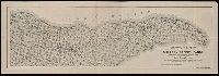
- From the Richard H. Rickard Papers. and Oriented with north to the upper right.
- Publisher:
- A.P. Meads,
- Subject (Geographic):
- Keweenaw Peninsula (Mich.)--Maps. and Michigan--Keweenaw Peninsula
- Subject (Name):
- Rickard, Richard H.,---1885--Ownership. and Weber, William Christian,--1853-1952.
- Subject (Topic):
- Copper mines and mining and Copper mines and mining--Michigan--Keweenaw Peninsula--Maps.
- Found in:
- Beinecke Rare Book and Manuscript Library > Sectional map of the Michigan Copper Range [cartographic material] : from Keweenaw Point to Lake Gogebic, showing the course and boundaries of the copper-bearing formation : also the exact location of the producing mines and those in progress of developme