Ishmaev, I. N Li︠a︡pidus, L. B Soviet Union. Glavnoe upravlenie geodezii i kartografii Soviet Union. Главное управление геодезии и картографии Ишмаев, И. Н Ляпидус, Л. Б
Published / Created:
[1948?]
Call Number:
35 1947A
Container / Volume:
BRBL_00101
Image Count:
1
Resource Type:
Maps, Atlases & Globes
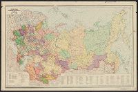
Alternative Title:
Политико-административная карта СССР / составлено Научно-редакционной картосоставительской частью ГУГК при Совете Министров СССР ; оформлено и отпечатано Новосибирской картографической фабрикой ГУГК при Совете Министров СССР ; ответственные редакторы, Ишм
Description:
"V-77.", "В-77.", and Includes list of administrative divisions.
Publisher:
Glavnoe upravlenie geodezii i kartografii pri Sovete Ministrov SSSR, and Главное управление геодезии и картографии при Совете Министров СССР,
Subject (Geographic):
Soviet Union--Administrative and political divisions--Maps
Ishmaev, I. N Li︠a︡pidus, L. B Soviet Union. Glavnoe upravlenie geodezii i kartografii Soviet Union. Главное управление геодезии и картографии Ишмаев, И. Н Ляпидус, Л. Б
Published / Created:
[1948?]
Call Number:
35 1947A
Container / Volume:
BRBL_00101
Image Count:
1
Resource Type:
Maps, Atlases & Globes
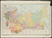
Alternative Title:
Политико-административная карта СССР / составлено Научно-редакционной картосоставительской частью ГУГК при Совете Министров СССР ; оформлено и отпечатано Новосибирской картографической фабрикой ГУГК при Совете Министров СССР ; ответственные редакторы, Ишм
Description:
"G-58.", "Г-58.", and Includes list of administrative divisions.
Publisher:
Glavnoe upravlenie geodezii i kartografii pri Sovete Ministrov SSSR, and Главное управление геодезии и картографии при Совете Министров СССР,
Subject (Geographic):
Soviet Union--Administrative and political divisions--Maps