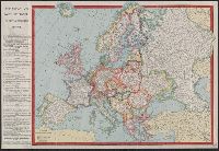
First complete map of the cities of New York, Brooklyn and Williamsburgh
Description:
Imperfect: torn along folds, with no loss of text. No. 1 of 2 titles bound together., Includes street directory and 3 views: University, Washington Square -- City of New York -- City Hall., Orientations differ., and Shows streets, ward boundaries, ferry routes,
Publisher:
C. Magnus,
Subject (Geographic):
Brooklyn (New York, N.Y.)--Maps, Manhattan (New York, N.Y.)--Maps, New York (N.Y.)--Maps, New York (State)--New York, New York (State)--New York--Brooklyn, and New York (State)--New York--Manhattan
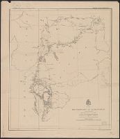
In top margin: Brig. Genl. A.A. Humphreys, Chief of Engineers, U.S.A. ; Brig. Gen'l A.H. Terry, comdg department., Includes notes indicating general topography., Relief shown by hachures and spot heights., and Shows exploration routes and dates.
Publisher:
American Photo-Lithographic Co.,
Subject (Geographic):
Black Hills (S.D. and Wyo.)--Maps and Dakota Territory--Maps
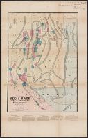
"Entered according to Act of Congress A.D. 1876 by Walton Van Loan ...", Advertisement on verso., Inset: Section of mountains covered by this map, as seen on approach from Catskill., Mounted on linen., Relief shown by hachures and spot heights., and Shows also bui
Publisher:
L. Neuman, lith.,
Subject (Geographic):
Catskill Forest Preserve (N.Y.)--Maps and Catskill Mountains (N.Y.)--Maps
Subject (Name):
Catskill Mountain House (Hotel)--Maps
Subject (Topic):
Trails--New York (State)--Catskill Mountains--Maps
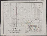
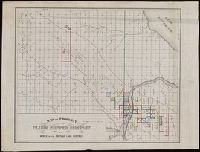
Globe Copper Company and Globe Copper Company--Maps
Subject (Topic):
Copper mines and mining--Michigan--Houghton County--Maps, Landowners--Michigan--Houghton County--Maps, and Real property--Michigan--Houghton County--Maps
From the Richard H. Rickard Papers. and Oriented with north to the right.
Publisher:
J.O. Seymour & Co.,
Subject (Geographic):
Houghton County (Mich.)--Maps.
Subject (Name):
Globe Copper Company., Globe Copper Company--Maps., and Rickard, Richard H.,---1885--Ownership.
Subject (Topic):
Copper mines and mining--Michigan--Houghton County--Maps., Landowners--Michigan--Houghton County--Maps., and Real property--Michigan--Houghton County--Maps.
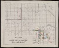
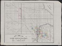
Globe Copper Company and Globe Copper Company--Maps
Subject (Topic):
Copper mines and mining--Michigan--Houghton County--Maps, Landowners--Michigan--Houghton County--Maps, and Real property--Michigan--Houghton County--Maps
"Entered according to act of Congress in the year 1866 by Julius Silversmith, for John Todd and E.H. Welton, in the clerk's office of the district court of the United States for the southern district of New York.", Includes text endorsing map., and Library's copy includes pen-and-ink note in upper right margin from publisher to Sanderson[?] Smith.
Publisher:
D. Van Nostrand,
Subject (Name):
Buel, D. E, D. Van Nostrand Company, Silversmith, Julius, Todd, John, compiler, and Todd, Joseph
Subject (Topic):
Mining districts--Death Valley Region (Calif. and Nev.)--Maps and Mining districts--Nevada--Maps