Skip to search
Skip to main content
Skip to first result
Search
You Searched For
"North America--Maps"
Extent of Digitization
Completely digitized
Resource Type
Maps, Atlases & Globes
Creator
G.W. & C.B. Colton & Co
Publication Place
New York :
New Search
Search Results
Creator:
Published / Created:
1870
Call Number:
80 1870
Container / Volume:
BRBL_00535
Image Count:
1
Resource Type:
Maps, Atlases & Globes
Alternative Title:
Map of the states and territories from the Mississippi River to the Pacific Ocean
Description:
"Entered according to act of Congress in the year 1867 by G.W. & C.B. Colton ... ", Also shows locations of Indian tribes., Includes text., Prime meridians: Greenwich and Washington., and Relief shown by hachures and spot heights.
Publisher:
G.W. and C.B. Colton,
Subject (Geographic):
Overland Trails--Maps and West (U.S.)--Maps
Subject (Topic):
Indians of North America --Maps
Found in:
Beinecke Rare Book and Manuscript Library > Colton's map of the states and territories west of the Mississippi River to the Pacific Ocean : showing the overland routes, projected rail road lines, &c.
Creator:
Published / Created:
1870
Call Number:
80 1881
Container / Volume:
BRBL_00536
Image Count:
1
Resource Type:
Maps, Atlases & Globes
Alternative Title:
Map of the states and territories from the Mississippi River to the Pacific Ocean
Description:
"Entered according to act of Congress in the year 1874 by G.W. & C.B. Colton ... ", Also shows locations of Indian tribes., Includes text., Prime meridians: Greenwich and Washington., and Relief shown by hachures and spot heights.
Publisher:
G.W. and C.B. Colton,
Subject (Geographic):
Overland Trails--Maps and West (U.S.)--Maps
Subject (Topic):
Indians of North America --Maps
Found in:
Beinecke Rare Book and Manuscript Library > Colton's map of the states and territories west of the Mississippi River to the Pacific Ocean : showing the overland routes, projected rail road lines, &c.
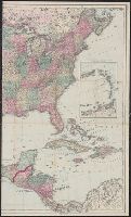
Creator:
Published / Created:
1869
Call Number:
75 1869A
Container / Volume:
BRBL_00404
Image Count:
2
Resource Type:
Maps, Atlases & Globes
Description:
Insets: The eastern portion of the West India Islands., Prime meridians: Greenwich, Washington., and Relief shown by hachures.
Publisher:
G.W. and C.B. Colton & Co.,
Subject (Geographic):
North America --Maps
Found in:
Beinecke Rare Book and Manuscript Library > Colton's map of the United States of America, the British provinces, Mexico and the West Indies : showing the country from the Atlantic to the Pacific Ocean.
Branch:v1.61.6 ,Deployed:2024-06-12T09:55:36-04:00