Skip to search
Skip to main content
Skip to first result
Search
You Searched For
Extent of Digitization
Completely digitized
Format
cartographic
Publication Place
New York :
Search Results
Published / Created:
[1909?]
Call Number:
771 N49 1609
Image Count:
1
Resource Type:
Maps, Atlases & Globes
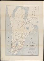
Description:
This map is based upon the early colonial surveys of ...
Publisher:
Townsend Macoon,
Subject (Geographic):
New York (N.Y.)--Maps--Early works to 1800
Found in:
Beinecke Rare Book and Manuscript Library > 1609 The Island of Manhattan (Mannahtin) at the time of its discovery ... L.L. Coates Engr'g Co., N.Y.
Creator:
Published / Created:
©1909.
Call Number:
771 N49 1664
Container / Volume:
BRBL_00483
Image Count:
1
Resource Type:
Maps, Atlases & Globes
Alternative Title:
Amsterdam in New Netherland, Early New York., and New Amsterdam 1653-1664
Description:
"The personal names are those of the more prominent citizens of that period with the location of their homes."
Publisher:
Townsend MacCoun,
Subject (Geographic):
Manhattan (New York, N.Y.)--History--Colonial period, ca. 1600-1775--Maps, New York (N.Y.)--History--Colonial period, ca. 1600-1775--Maps, and New York (N.Y.)--Maps
Subject (Name):
L.L. Poates Engr'g Co
Found in:
Beinecke Rare Book and Manuscript Library > 1653-1664 Amsterdam in New Netherland [cartographic material] : the city of the Dutch West India Company / by Townsend MacCoun ; L.L. Poates Engr'g. Co.
Creator:
Published / Created:
©1909.
Call Number:
771 N49 1730
Container / Volume:
BRBL_00484
Image Count:
1
Resource Type:
Maps, Atlases & Globes
Alternative Title:
New York 1730 and New York, the English Colonial city
Description:
"The principal points of interest for this period are in red."
Publisher:
Townsend MacCoun,
Subject (Geographic):
Manhattan (New York, N.Y.)--History--Colonial period, ca. 1600-1775--Maps, New York (N.Y.)--History--Colonial period, ca. 1600-1775--Maps, and New York (N.Y.)--Maps
Found in:
Beinecke Rare Book and Manuscript Library > 1730 New York, the English Colonial city / by Townsend MacCoun ; L.L. Poates Engr'g. Co.
Published / Created:
[1909?]
Call Number:
771 N49 1783
Container / Volume:
BRBL_00484
Image Count:
1
Resource Type:
Maps, Atlases & Globes
Publisher:
Townsend Macoon,
Subject (Geographic):
New York (N.Y.)--Maps--Early works to 1800
Found in:
Beinecke Rare Book and Manuscript Library > 1783 Manhattan Island at the close of the Revolution showing the American City with its Landmarks ... Fortifications ... L.L. Poates Engr'g Co., N.Y.
Creator:
Published / Created:
1867, c1866.
Call Number:
771 N49 1867A
Container / Volume:
BRBL_00487
Image Count:
2
Resource Type:
Maps, Atlases & Globes
Alternative Title:
Forty miles around New York., H.H. Lloyd's new map of the great metropolis., H.H. Lloyd's New-York and forty miles around it., New map of the great metropolis., and New-York and forty miles around it.
Description:
Includes lists of maps published by the company (on map)
Publisher:
H.H. Lloyd & Co.,
Subject (Geographic):
New York (N.Y.)--Maps and New York Region--Maps
Found in:
Beinecke Rare Book and Manuscript Library > 40 miles around New York ; H.H. Lloyd's new map of the great metropolis, : including the cities of New York, Brooklyn, Jersey City, Hoboken, &c.
Published / Created:
1825
Call Number:
23cea 1825
Container / Volume:
BRBL_00021
Image Count:
2
Resource Type:
Maps, Atlases & Globes
Description:
Covers the coast from 21° 30' North to 7° South Latitude.
Publisher:
Richard Patten,
Subject (Geographic):
Pacific Ocean--Maps
Found in:
Beinecke Rare Book and Manuscript Library > A Chart of the West Coast of America ... from the latest Spanish surveys. Engraved by J.M. Taylor, NY.
Published / Created:
1796
Call Number:
90 1796
Container / Volume:
BRBL_00661
Image Count:
1
Resource Type:
Maps, Atlases & Globes
Description:
B. Tanner sculpt.
Publisher:
John Reid,
Subject (Geographic):
South America--Maps--Early works to 1800
Found in:
Beinecke Rare Book and Manuscript Library > A General Map Of South America. from the Best Surveys.
Published / Created:
1831
Call Number:
911cea 1831
Container / Volume:
BRBL_00670
Image Count:
1
Resource Type:
Maps, Atlases & Globes
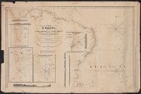
Description:
Insets: Rio Grande, Rio Janeiro, St. Salvador, Pernambuco.
Publisher:
Rd. Patter,
Subject (Geographic):
Brazil--Maps
Found in:
Beinecke Rare Book and Manuscript Library > A New General Chart of the Coast of Brazil ... order of the Portuguese Government ... by Joseph Foss Dessiou ... London by W. Faden ... 1818.
Published / Created:
1841
Call Number:
213cea 1819
Image Count:
1
Resource Type:
Maps, Atlases & Globes
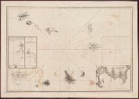
Description:
Inset: Plan of Porto Praya, in the Island of St. Jago.
Publisher:
E. & G.W. Blunt,
Subject (Geographic):
Cape Verde--Maps
Found in:
Beinecke Rare Book and Manuscript Library > A chart of the Cape Verd[e] Islands by Lieuts. Vidal & Mudge, of H.M. Ship Leven ... in 1819,20 & 21. Engraved & Printed by W. Hooker.
Creator:
Published / Created:
1847
Call Number:
88hc 1847A
Container / Volume:
BRBL_00649
Image Count:
1
Resource Type:
Maps, Atlases & Globes
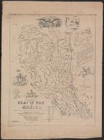
Alternative Title:
Map of the seat of war in Mexico
Description:
"Entered according to act of Congress in the year 1847 by J.G. Bruff ...."
Publisher:
J. Disturnell,
Subject (Geographic):
Mexico--Maps
Subject (Name):
Jones & Newman, Muhlenberg, Henry A. (Henry Augustus), 1823-1854, and Probst, John, b. ca. 1805
Subject (Topic):
Mexican War, 1846-1848--Maps, Palo Alto, Battle of, Tex., 1846--Maps, and Resaca de la Palma, Battle of, Tex., 1846--Maps
Found in:
Beinecke Rare Book and Manuscript Library > A correct map of the seat of war in Mexico : being a copy of Gen.l Arista's map taken at Resaca de la Palma with additions and corrections, embellished with diagrams of the battles of 8th & 9th May, and capture of Monterey, with a memorandum of forces eng