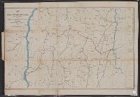
Covers areas of N.Y., Conn., and Mass. surrounding their intersection. and Includes ancillary "Profile of the Dutchess and Columbia and the proposed Connecticut Western Rail Road."
Publisher:
H.H. Lloyd & Co.'s Map Establishment,
Subject (Geographic):
Connecticut--Maps, Massachusetts--Maps, and New York (State)--Maps
Subject (Name):
Connecticut Western Railroad Co.--Maps and Dutchess and Columbia Railroad Co.--Maps
Subject (Topic):
Railroads--Connecticut--Maps, Railroads--Massachusetts--Maps, and Railroads--New York (State)--Maps
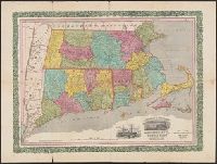
Horace Thayer & Co.'s map of Mass., Conn. & R.I. and Railroad & township map of Massachusetts, Connecticut and Rhode Island
Description:
Borders of counties in red, yellow, green and blue; borders of Connecticut and Rhode Island in red., Cover title: Horace Thayer & Co.'s map of Mass., Conn. & R.I., In purplish black cloth covered folder with gold title within decorative border., and Includes vig