Skip to search
Skip to main content
Skip to first result
Search
You Searched For
Extent of Digitization
Completely digitized
Publication Place
New York :
New Search
Search Results
Published / Created:
1836
Call Number:
771 H154 1836
Container / Volume:
BRBL_00482A
Image Count:
1
Resource Type:
Maps, Atlases & Globes
Publisher:
P.A. Messier's Lith.,
Subject (Geographic):
New York--Maps
Found in:
Beinecke Rare Book and Manuscript Library > Map of 134 Building at Hallett's Cove, L.I. For sale by order of the Ct. of Chancery at the store of F.H. Blackwell & Co. at Hallet's Cove on the 7th of May, 1836.
Published / Created:
[1936]
Call Number:
848 1936
Container / Volume:
BRBL_00631
Image Count:
1
Resource Type:
Maps, Atlases & Globes
Alternative Title:
Bulletin of the American Museum of Natural History.
Description:
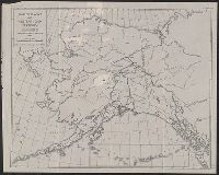
"Adapted mainly from Alaska map E of the U.S.G.S.", In top margin: Bulletin A.M.N.H., vol. LXXIV, art. I., and Includes inset of Aleutian Islands.
Publisher:
American Museum of Natural History,
Subject (Geographic):
Alaska--Maps
Subject (Name):
American Museum of Natural History and Bradley, D.F. Levett
Subject (Topic):
Paleontology--Alaska--Maps and Paleontology--Yukon Territory--Maps
Found in:
Beinecke Rare Book and Manuscript Library > Map of Alaska and western Yukon Territory : showing route of American Museum Palaeontological Expedition, 1936 / D.F. Levett Bradley.
Published / Created:
1858
Call Number:
771 B796 1776
Container / Volume:
BRBL_00481
Image Count:
1
Resource Type:
Maps, Atlases & Globes
Description:
Geo. Hayward, N.Y., Lith. and Gives houses and names of owners, position of boats, streets and names.
Publisher:
DT Valentine's Manual,
Subject (Geographic):
Brooklyn (New York, N.Y.)--Maps--Early works to 1800
Found in:
Beinecke Rare Book and Manuscript Library > Map of Brooklyn at the time of the Revolutionary war drawn by Genl. Geremish Johnson.
Creator:
Published / Created:
1849
Call Number:
844 1849D
Container / Volume:
BRBL_00601
Image Count:
1
Resource Type:
Maps, Atlases & Globes
Alternative Title:
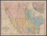
Tanner's travelling map of California &c, Travelling map of California, and United States, Mexico &c, showing the routes from N. York to St. Francisco by land & water.
Description:
Includes inset of "United States, Mexico &c, showing the routes from N. York to St. Francisco by land & water.", Library's copy 2 mounted on linen, without cover., Relief shown by hachures., Shows the New Southwest and parts of Texas and Mexico., and Text inside front cover, "Table of routes from New-York to California with the modes of conveyance, distances, time and fares."
Publisher:
H.S. Tanner,
Subject (Geographic):
California--Gold discoveries--Maps, California--Maps, Mexico--Maps, and Southwest, New--Maps
Subject (Topic):
Gold mines and mining--California--Maps
Found in:
Beinecke Rare Book and Manuscript Library > Map of California, New Mexico, Texas &c.
Creator:
Published / Created:
1849
Call Number:
844 1849G
Container / Volume:
BRBL_00601
Image Count:
1
Resource Type:
Maps, Atlases & Globes
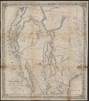
Description:
"Entered according to act of Congress in the year 1849 by J.H. Colton in the clerk's office of the district court for the southern district of New York.", In bottom margin: Appleton & Co. New York., Includes text and distance table., and Prime meridians: Greenwich and Washington.
Publisher:
J.H. Colton,
Subject (Geographic):
California--Maps and West (U.S.)--Maps
Subject (Name):
Ackerman Lithr and D. Appleton and Company
Found in:
Beinecke Rare Book and Manuscript Library > Map of California, Oregon, Texas, and the territories adjoining, with routes &c.
Creator:
Published / Created:
[1857?]
Call Number:
814 C386 1857
Container / Volume:
BRBL_00558
Image Count:
1
Resource Type:
Maps, Atlases & Globes
Description:
Oriented with north to upper right.
Publisher:
E.B. Hood,
Subject (Geographic):
Chaska (Minn.)--Maps
Subject (Name):
Fuller & Co. (Chaska, Minn.) and Robertson & Seibert (Firm : New York, N.Y.)
Found in:
Beinecke Rare Book and Manuscript Library > Map of Chaska and Fullers Addition : county seat of Carver County, Minnesota / surveyed, drawn & published for Fuller & Co. by E.B. Hood, C.E., New York.
Creator:
Published / Created:
[1943?]
Call Number:
56 1937
Container / Volume:
BRBL_00296
Image Count:
1
Resource Type:
Maps, Atlases & Globes
Description:
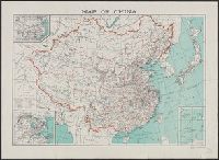
"Reprinted from the China Handbook 1937-1943, compiled by the Ministry of Information and published by the Macmillan Company, New York." and Includes three inset maps.
Publisher:
Macmillan Co.,
Subject (Geographic):
China--Maps
Found in:
Beinecke Rare Book and Manuscript Library > Map of China [cartographic material] / compiled by the Chinese Ministry of Information.
Published / Created:
1835
Call Number:
804 C599 1835
Container / Volume:
BRBL_00544
Image Count:
1
Resource Type:
Maps, Atlases & Globes
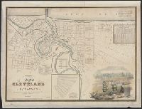
Description:
Includes views of sixs buildings.
Publisher:
N. Currier's Lith.y,
Subject (Geographic):
Cleveland (Ohio)--Maps
Found in:
Beinecke Rare Book and Manuscript Library > Map of Cleveland and its Environs. Surveyed and Published gy Ahaz Merchant.
Creator:
Published / Created:
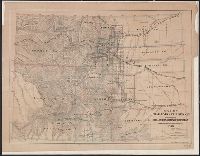
1866
Call Number:
834 1866
Container / Volume:
BRBL_00587
Image Count:
1
Resource Type:
Maps, Atlases & Globes
Alternative Title:
Colorado Territory to accompany Hollisters "Mines of Colorado"
Description:
Relief shown by hachures. and Shows coal deposits, gold and silver mines, towns, roads, railroads, townships and natural features.
Publisher:
The Major & Knapp Engraving, Manufg and Lithographic Co.,
Subject (Geographic):
Colorado--Maps
Subject (Name):
Hollister, Ovando James, 1834-1892. Mines of Colorado and Major & Knapp Engraving, Manufacturing & Lithographic Co
Subject (Topic):
Coal--Colorado--Maps, Gold mines and mining--Colorado--Maps, and Silver mines and mining--Colorado--Maps
Found in:
Beinecke Rare Book and Manuscript Library > Map of Colorado Territory to accompany Hollisters "Mines of Colorado" corrected from the Public Surveys of 1866.
Creator:
Published / Created:
[1896]
Call Number:
BrSides Folio 2017 10
Image Count:
2
Resource Type:
Maps, Atlases & Globes
Alternative Title:
Map of Cook's tours in Ireland. and Map of Cook's tours in Scotland & England.
Description:
Coordinates not present on map and are approximated., Imperfect: brittle and chipped, with some loss of text., Inset: Portion of Norway and Sweden., On verso: Map of Cook's tours in Ireland; Map of Cook's tours in Scotland & England., and Shows railroads, "Railways over which Cook's tickets are available," and steamship routes.
Publisher:
Published by Thos. Cook & Son Cook,
Subject (Geographic):
Europe--Tours--Maps.
Subject (Name):
Thomas Cook (Firm)
Subject (Topic):
Railroads--Europe--Maps.
Found in:
Beinecke Rare Book and Manuscript Library > Map of Cook's tours in Europe.
Branch:v1.61.8 ,Deployed:2024-06-20T11:14:48-04:00