Search
You Searched For
Search Results
- Published / Created:
- 1879
- Call Number:
- 771 N51 1879
- Container / Volume:
- BRBL_00489
- Image Count:
- 1
- Resource Type:
- Maps, Atlases & Globes
- Found in:
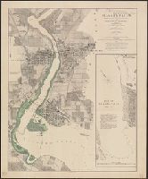
- Beinecke Rare Book and Manuscript Library > Map of Niagara Falls showing proposed reservations for the protection of scenery approved by the commissioners of the New York State Survey. And the representatives of the Province of Ontario / James T. Gardner director N.Y. State survey.
- Creator:
- Smith, J. Calvin (John Calvin)
- Published / Created:
- 1850
- Call Number:
- 71 1850A
- Container / Volume:
- BRBL_00370
- Image Count:
- 1
- Resource Type:
- Maps, Atlases & Globes
- Found in:
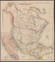
- Beinecke Rare Book and Manuscript Library > Map of North America / by J. Calvin Smith.
- Creator:
- Smith, J. Calvin (John Calvin)
- Published / Created:
- 1851
- Call Number:
- 71 1851A
- Container / Volume:
- BRBL_00370
- Image Count:
- 1
- Resource Type:
- Maps, Atlases & Globes
- Found in:
- Beinecke Rare Book and Manuscript Library > Map of North America / by J. Calvin Smith.
- Creator:
- Colton, Ohman & Co
- Published / Created:
- 1900
- Call Number:
- 38 P21 1900B
- Container / Volume:
- BRBL_00164
- Image Count:
- 1
- Resource Type:
- Maps, Atlases & Globes
- Found in:
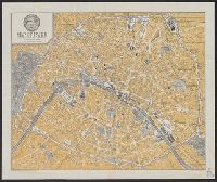
- Beinecke Rare Book and Manuscript Library > Map of Paris, France [cartographic material] / engraved for The Commercial Cable Co. by Colton, Ohman & Co. ; copyright ... by Colton, Ohman & Co.
- Creator:
- Hunt, Richard S
- Published / Created:
- [1841?]
- Call Number:
- 796 1841A
- Container / Volume:
- BRBL_00524
- Image Count:
- 1
- Resource Type:
- Maps, Atlases & Globes
- Found in:
- Beinecke Rare Book and Manuscript Library > Map of Texas / compiled from surveys on record in the general land office of the republic, to the year 1841, by Richard S. Hunt and Jesse F. Randel ; engraved by Stiles, Sherman & Smith.
- Published / Created:
- 1823
- Call Number:
- 85 1492
- Container / Volume:
- BRBL_00636
- Image Count:
- 1
- Resource Type:
- Maps, Atlases & Globes
- Found in:
- Beinecke Rare Book and Manuscript Library > Map of The Route of Colombus on arriving among the Bahama Islands. Plan by D.G. Johnson
- Published / Created:
- 1823
- Call Number:
- 85 1492
- Container / Volume:
- BRBL_00636
- Image Count:
- 1
- Resource Type:
- Maps, Atlases & Globes
- Found in:
- Beinecke Rare Book and Manuscript Library > Map of The Route of Colombus on arriving among the Bahama Islands. Plan by D.G. Johnson
- Creator:
- Whiting, Charles J
- Published / Created:
- 1850
- Call Number:
- 844 V243 1850
- Container / Volume:
- BRBL_00611
- Image Count:
- 1
- Resource Type:
- Maps, Atlases & Globes
- Found in:
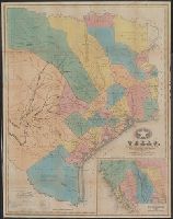
- Beinecke Rare Book and Manuscript Library > Map of Vallejo, California / surveyed by Chas. J. Whiting, Surveyor General of the State of California, by order of the Legislature.
- Creator:
- White, Charles A. (Charles Abiathar), 1826-1910
- Published / Created:
- 1870
- Call Number:
- 847 1870
- Container / Volume:
- BRBL_00625
- Image Count:
- 4
- Resource Type:
- Maps, Atlases & Globes
- Found in:
- Beinecke Rare Book and Manuscript Library > Map of Washington Territory : west of the Cascade Mountains / compiled from the government surveys by Chas. A. White, C.E.
- Published / Created:
- 1870
- Call Number:
- 783gme 1870
- Container / Volume:
- BRBL_00510
- Image Count:
- 1
- Resource Type:
- Maps, Atlases & Globes
- Found in:
- Beinecke Rare Book and Manuscript Library > Map of West Point Harbor and rail road lines.