Search
You Searched For
Search Results
- Published / Created:
- 1850
- Call Number:
- 754gme 1850
- Container / Volume:
- BRBL_00419
- Image Count:
- 1
- Resource Type:
- Maps, Atlases & Globes
- Found in:
- Beinecke Rare Book and Manuscript Library > [Railroads of the Lake States, from Great Lakes to Ohio River]
- Published / Created:
- [ca. 1905]
- Call Number:
- 771 N49 1905R
- Image Count:
- 1
- Resource Type:
- Maps, Atlases & Globes
- Found in:
- Beinecke Rare Book and Manuscript Library > [New York City real estate].
- Published / Created:
- c1915.
- Call Number:
- 902 1915
- Container / Volume:
- BRBL_00665
- Image Count:
- 1
- Resource Type:
- Maps, Atlases & Globes
- Found in:
- Beinecke Rare Book and Manuscript Library > [Map of Colombia].
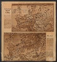
- Published / Created:
- 1940
- Call Number:
- 30hd 1940I
- Container / Volume:
- BRBL_00038
- Image Count:
- 1
- Resource Type:
- Maps, Atlases & Globes
- Found in:
- Beinecke Rare Book and Manuscript Library > [Europe-Western Battle Lines].
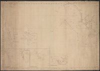
- Creator:
- E. & G.W. Blunt (Firm)
- Published / Created:
- [between 1827? and 1850?]
- Call Number:
- 21cea 1830
- Container / Volume:
- BRBL_00016
- Image Count:
- 1
- Resource Type:
- Maps, Atlases & Globes
- Found in:
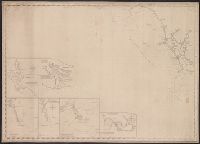
- Beinecke Rare Book and Manuscript Library > [Coast chart from Cape Hatteras to Cape Fear, North Carolina [cartographic material] : with insets of Cape Hatteras, Ocracoke Bar and Roads, Cape Lookout, Beaufort Harbour, Cape Fear, and the Cape Fear River] / engraved & printed by W. Hooker.
- Published / Created:
- [1840?]
- Call Number:
- 785 C17 1840
- Container / Volume:
- BRBL_00513
- Image Count:
- 1
- Resource Type:
- Maps, Atlases & Globes
- Found in:
- Beinecke Rare Book and Manuscript Library > [Cape Hatteras.]
- Published / Created:
- 1940
- Call Number:
- 11hc 1915C
- Container / Volume:
- BRBL_00010B
- Image Count:
- 2
- Resource Type:
- Maps, Atlases & Globes
- Found in:
- Beinecke Rare Book and Manuscript Library > [A soldier saved a map.]
- Published / Created:
- 1847
- Call Number:
- 11 1847
- Container / Volume:
- BRBL_00008
- Image Count:
- 1
- Resource Type:
- Maps, Atlases & Globes
- Found in:
- Beinecke Rare Book and Manuscript Library > World at one view.
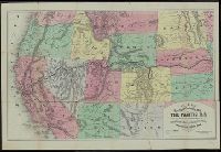
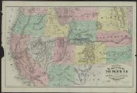
- Creator:
- Williams, Henry T
- Published / Created:
- [1877?]
- Call Number:
- 80gme 1877A
- Container / Volume:
- BRBL_00539
- Image Count:
- 2
- Resource Type:
- Maps, Atlases & Globes
- Found in:
- Beinecke Rare Book and Manuscript Library > Williams' new trans-continental map of the Pacific R.R. and routes of overland travel to Colorado, Nebraska, the Black Hills, Utah, Idaho, Nevada, Montana, California, and the Pacific coast.
- Creator:
- Williams, Henry T
- Published / Created:
- [1876?]
- Call Number:
- 80gme 1876C
- Container / Volume:
- BRBL_00539
- Image Count:
- 2
- Resource Type:
- Maps, Atlases & Globes
- Found in:
- Beinecke Rare Book and Manuscript Library > Williams' new trans-continental map of the Pacific R.R. and routes of overland travel to Colorado, Nebraska, the Black Hills, Utah, Idaho, Nevada, Montana, California and the Pacific coast / Henry T. Williams.