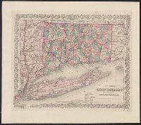
Includes key to symbols. and Includes Long Island and adjoining portions of Massachusetts, Rhode Island, and New York, including the Hudson River Valley northward to Malden.
Publisher:
G. W. and C. B. Colton,
Subject (Geographic):
Connecticut--Maps, Hudson River Valley--Maps, Long Island (N.Y.)--Maps, New York (State)--Maps, and Rhode Island--Maps
1 inch = ca. 10 miles., Advertisement for their maps, on front pastedown., Colored by town; borders of counties and of states in red., and In brown cloth covered folder, with "Colton's Map of Connecticut" and publisher's name in gold, surrounded by curvilinear d
Publisher:
G.W. and C.B. Colton,
Subject (Geographic):
Connecticut--Maps, Long Island (N.Y.)--Maps, and New York (State)--Maps
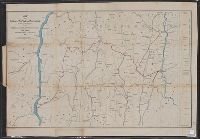
Covers areas of N.Y., Conn., and Mass. surrounding their intersection. and Includes ancillary "Profile of the Dutchess and Columbia and the proposed Connecticut Western Rail Road."
Publisher:
H.H. Lloyd & Co.'s Map Establishment,
Subject (Geographic):
Connecticut--Maps, Massachusetts--Maps, and New York (State)--Maps
Subject (Name):
Connecticut Western Railroad Co.--Maps and Dutchess and Columbia Railroad Co.--Maps
Subject (Topic):
Railroads--Connecticut--Maps, Railroads--Massachusetts--Maps, and Railroads--New York (State)--Maps
Includes population chart and index to ownership of electric railways., Inset: Map showing the lines of communication between New York, Boston and the West., and Relief shown by shading and spot heights.