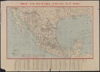
"Canal Data" text at bottom of sheet., Inset showing "Geographical postion of the Panama Canal"., and Notations in red showing steamship routes on both ends of Canal.
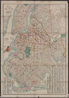
Fire insurance map, colored to show building construction, property boundaries and house and block numbers.
Alternative Title:
Milford, Del., Milford, Delaware, and Nov. 1919, Milford, Del.
Description:
"15 sheets (2932).", Coordinates not present on map and are approximated., Includes index to streets and buildings., Sheet 1 includes key to building colors and other features of construction, water facilities and fire department, index map for the adjoining sheets., and Stamps below title: CLF 33891; Feb. 13, 1920.
Publisher:
Sanborn Map Company,
Subject (Geographic):
Milford (Del.)--Maps.
Subject (Topic):
Fire risk assessment--Delaware--Milford--Maps. and Real property--Delaware--Milford--Maps.
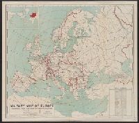
Includes table showing area and populations of the European powers., Indicates fortified towns, military headquarters, naval stations, railroads; concentric circl, Inset of location map of the world with Europe highlighted in red., and Prime meridian: Greenwich.
Publisher:
General Drafting Co.,
Subject (Geographic):
Europe--Maps
Subject (Topic):
World War, 1914-1918--Europe--Maps and World War, 1914-1918--Maps
Lithographed map colored to show conflagration sections (by red numerals), normal, bad, and very bad blocks, proposed hydrants and companies, present companies, etc. Also shows city blocks, engine ladder, hose, chemical, water tower, fire-boat companies, etc.
Lithograph showing present mains 10" in diameter or larger, Mains 12" or larger proposed or under construction by water dept. Arteries proposed by National Board for immediate installation. Serial Nos. indicate location of hydrant tests. Colored to show areas of static pressures at hydrants as observed by National Board Engineers between 9 A.M. and 5 P.M.