Skip to search
Skip to main content
Skip to first result
Search
You Searched For
Date
1820 - 1839
Format
cartographic
Publication Place
New York :
Date Created
1820 to 1839
New Search
Search Results
Published / Created:
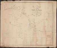
1825
Call Number:
23cea 1825
Container / Volume:
BRBL_00021
Image Count:
2
Resource Type:
Maps, Atlases & Globes
Description:
Covers the coast from 21° 30' North to 7° South Latitude. and Preliminary record.
Publisher:
Richard Patten,
Subject (Geographic):
Pacific Ocean--Maps
Found in:
Beinecke Rare Book and Manuscript Library > A Chart of the West Coast of America ... from the latest Spanish surveys. Engraved by J.M. Taylor, NY.
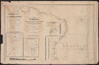
Published / Created:
1831
Call Number:
911cea 1831
Container / Volume:
BRBL_00670
Image Count:
1
Resource Type:
Maps, Atlases & Globes
Description:
Insets: Rio Grande, Rio Janeiro, St. Salvador, Pernambuco. and Republished by Rd. Patter 1831.
Publisher:
Rd. Patter,
Subject (Geographic):
Brazil--Maps
Found in:
Beinecke Rare Book and Manuscript Library > A New General Chart of the Coast of Brazil ... order of the Portuguese Government ... by Joseph Foss Dessiou ... London by W. Faden ... 1818.
Published / Created:
1823
Call Number:
792cea 1823
Container / Volume:
BRBL_00519
Image Count:
1
Resource Type:
Maps, Atlases & Globes
Publisher:
Richard Pattern,
Subject (Geographic):
Florida--Maps
Found in:
Beinecke Rare Book and Manuscript Library > A particular Chart of the coasts of West Florida Louisiana Mississippi & Alabama ...
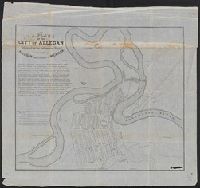
Published / Created:
1836
Call Number:
811 Al53 1836
Container / Volume:
BRBL_00553
Image Count:
1
Resource Type:
Maps, Atlases & Globes
Publisher:
P.A.Mesier's Lith.,
Subject (Geographic):
Allegan County (Mich.)--Maps
Found in:
Beinecke Rare Book and Manuscript Library > A plan of the city of Allegan, situated on the Kalamazoo River in the County of Allegan and Territory of Michigan.
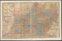
Published / Created:
1836
Call Number:
811 1836
Container / Volume:
BRBL_00552
Image Count:
1
Resource Type:
Maps, Atlases & Globes
Description:
Largest inset: Map of the Straits of Michillimackinac.
Publisher:
J.H. Colton,
Subject (Geographic):
Michigan--Maps
Found in:
Beinecke Rare Book and Manuscript Library > An improved edition of a map of the survryed part of the Territory of Michigan. by John Farmer
Published / Created:
1834
Call Number:
806gmb C43 1834
Container / Volume:
BRBL_00549
Image Count:
1
Resource Type:
Maps, Atlases & Globes
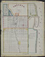
Description:
This is the first known City map of Chicago.
Publisher:
P.A.Mesier's Lith.,
Subject (Geographic):
Chicago (Ill.)--Maps
Found in:
Beinecke Rare Book and Manuscript Library > Chicago. Drwn by J.S.Wright, according to survey.
Published / Created:
1833
Call Number:
771 N49 1833
Container / Volume:
BRBL_00485
Image Count:
1
Resource Type:
Maps, Atlases & Globes
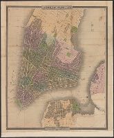
Description:
Engraved and printed by S. Stiles & Co. and Engraving tinted to show wards, squares, cemeteries, public buildings, the Navy yard, ect. Also shows ferry boat docks and distances of ferry travel.
Publisher:
J.H. Colton & Co.,
Subject (Geographic):
New York (N.Y.)--Maps
Found in:
Beinecke Rare Book and Manuscript Library > City of New York, by David H. Burr.
Creator:
Call Number:
771 N49 1828
Container / Volume:
BRBL_00485
Image Count:
1
Resource Type:
Maps, Atlases & Globes
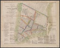
Alternative Title:
New pocket plan of the city of New York
Description:
"Entered according to act of Congress, the 27th day of March 1824, by Wm. Hooker of the state of N. York.", Covers Manhattan south of 15th Street on the west side and south of 31st Street on the east side., and Includes lists of distributors, churches, markets,
Publisher:
W. Hooker,
Subject (Geographic):
Manhattan (New York, N.Y.)--Maps, New York (N.Y.)--Administrative and political divisions--Maps., and New York (N.Y.)--Maps
Found in:
Beinecke Rare Book and Manuscript Library > Hooker's new pocket plan of the city of New York / compiled & surveyed by William Hooker, A.C.S.A., hydrographer & engraver.
Published / Created:
[1831?]
Call Number:
761 1831
Container / Volume:
BRBL_00447
Image Count:
1
Resource Type:
Maps, Atlases & Globes
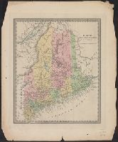
Publisher:
David H. Burr,
Subject (Geographic):
Maine--Maps
Found in:
Beinecke Rare Book and Manuscript Library > Maine.
Published / Created:
1836
Call Number:
771 H154 1836
Container / Volume:
BRBL_00482A
Image Count:
1
Resource Type:
Maps, Atlases & Globes
Publisher:
P.A. Messier's Lith.,
Subject (Geographic):
New York--Maps
Found in:
Beinecke Rare Book and Manuscript Library > Map of 134 Building at Hallett's Cove, L.I. For sale by order of the Ct. of Chancery at the store of F.H. Blackwell & Co. at Hallet's Cove on the 7th of May, 1836.
Branch:v1.61.8 ,Deployed:2024-06-20T11:15:15-04:00