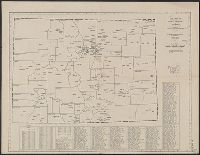
Fire insurance map, colored to show building construction, property boundaries and house and block numbers.
Alternative Title:
Aug. 1923, Bridgeville, Del. and Bridgeville, Del.
Description:
Coordinates not present on map and are approximated., Sheet 1 includes key to building colors and other features of construction, water facilities and fire department, index map for the adjoining sheets, and information about updates., Stamps below title: 427,0, Oct. 22, 1923., and Title from sheet 1.
Publisher:
Sanborn Map Company,
Subject (Geographic):
Bridgeville (Del.)--Maps.
Subject (Topic):
Fire risk assessment--Delaware--Bridgeville--Maps. and Real property--Delaware--Bridgeville--Maps.
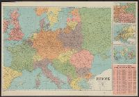
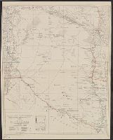
Below title: Map no. 405., Copyright: American Map Company, New York., Date from stamp: Mar 20 1931., Indexed., and Shows county seats and boundaries, with few other towns.
Publisher:
American Map Company,
Subject (Geographic):
Colorado--Administrative and political divisions--Maps and Colorado--Maps
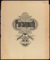
Plan showing the fire insurance risks of buildings in a city or town. Identifies commercial, industrial, and residential sections. Successive Sanborn maps show the physical evolution of buildings and neighborhoods in a given town.
Alternative Title:
Portsmouth, Va
Description:
"120 sheets ... (3124).", Coordinates not present on map and are approximated., Imperfect: all sheets after 21 wanting. Includes skeleton maps for sheets 3-6., Includes "Map of congested district of Portsmouth, Va." (scale 1:2,400)., Includes West Norfolk and Pinners Point., and Shows color-coded building construction material, locations of windows and doors, roof type, street widths and names, water facilities, proximity to fire stations, and population size.
Publisher:
Sanborn Map Company,
Subject (Geographic):
Portsmouth (Va.)--Maps
Subject (Topic):
Fire risk assessment--Virginia--Portsmouth--Maps. and Real property--Virginia--Portsmouth--Maps.
"Contours and altitudes in meters.", Relief shown by contours and spot heights. River depths shown by soundings., and Shows rivers - surveyed and unsurveyed, astronomical points, roads, trails, fortines/[bunkers] (Bolivian, Paraguayan or Argentine), settlements, indian settlements and mission stations.
"The Geographical Review, Vol. X. No. 6, 1920,Pl. I." and Includes inset map "Relation of the New Republic of Hungary to th eformer Austro-Hungarian Monarchy", scale 1:15,000,000.
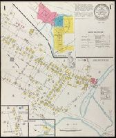
Fire insurance map, colored to show building construction, property boundaries and house and block numbers.
Alternative Title:
July 1923, Milton, Del. and Milton, Del.
Description:
"1131 (3 sheets).", Coordinates not present on map and are approximated., Index map at scale of 600 feet to 1 inch, or 1:7,200., Maps on sheets 1 and 3 are at a scale of 1:1200, map on sheet 2 is at a scale of 1:600., Partial cadastral map., and Sheet 1 includes key to building colors and other features of construction, water facilities and fire department, index map for the adjoining sheets, and information about updates.
Publisher:
Sanborn Map Company,
Subject (Geographic):
Milton (Del.)--Maps.
Subject (Topic):
Fire risk assessment--Delaware--Milton--Maps. and Real property--Delaware--Milton--Maps.