Search
You Searched For
Search Results
- Published / Created:
- [1909?]
- Call Number:
- 771 N49 1609
- Image Count:
- 1
- Resource Type:
- Maps, Atlases & Globes
- Found in:
- Beinecke Rare Book and Manuscript Library > 1609 The Island of Manhattan (Mannahtin) at the time of its discovery ... L.L. Coates Engr'g Co., N.Y.
- Creator:
- MacCoun, Townsend, 1845-1932
- Published / Created:
- ©1909.
- Call Number:
- 771 N49 1730
- Container / Volume:
- BRBL_00484
- Image Count:
- 1
- Resource Type:
- Maps, Atlases & Globes
- Found in:
- Beinecke Rare Book and Manuscript Library > 1730 New York, the English Colonial city / by Townsend MacCoun ; L.L. Poates Engr'g. Co.
- Published / Created:
- [1909?]
- Call Number:
- 771 N49 1783
- Container / Volume:
- BRBL_00484
- Image Count:
- 1
- Resource Type:
- Maps, Atlases & Globes
- Found in:
- Beinecke Rare Book and Manuscript Library > 1783 Manhattan Island at the close of the Revolution showing the American City with its Landmarks ... Fortifications ... L.L. Poates Engr'g Co., N.Y.
- Creator:
- H.H. Lloyd & Co
- Published / Created:
- 1867, c1866.
- Call Number:
- 771 N49 1867A
- Container / Volume:
- BRBL_00487
- Image Count:
- 2
- Resource Type:
- Maps, Atlases & Globes
- Found in:
- Beinecke Rare Book and Manuscript Library > 40 miles around New York ; H.H. Lloyd's new map of the great metropolis, : including the cities of New York, Brooklyn, Jersey City, Hoboken, &c.
- Published / Created:
- 1825
- Call Number:
- 23cea 1825
- Container / Volume:
- BRBL_00021
- Image Count:
- 2
- Resource Type:
- Maps, Atlases & Globes
- Found in:
- Beinecke Rare Book and Manuscript Library > A Chart of the West Coast of America ... from the latest Spanish surveys. Engraved by J.M. Taylor, NY.
- Published / Created:
- 1796
- Call Number:
- 90 1796
- Container / Volume:
- BRBL_00661
- Image Count:
- 1
- Resource Type:
- Maps, Atlases & Globes
- Found in:
- Beinecke Rare Book and Manuscript Library > A General Map Of South America. from the Best Surveys.
- Published / Created:
- 1831
- Call Number:
- 911cea 1831
- Container / Volume:
- BRBL_00670
- Image Count:
- 1
- Resource Type:
- Maps, Atlases & Globes
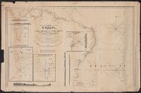
- Found in:
- Beinecke Rare Book and Manuscript Library > A New General Chart of the Coast of Brazil ... order of the Portuguese Government ... by Joseph Foss Dessiou ... London by W. Faden ... 1818.
- Published / Created:
- 1841
- Call Number:
- 213cea 1819
- Image Count:
- 1
- Resource Type:
- Maps, Atlases & Globes
- Found in:
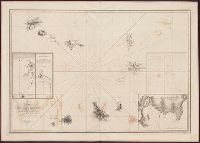
- Beinecke Rare Book and Manuscript Library > A chart of the Cape Verd[e] Islands by Lieuts. Vidal & Mudge, of H.M. Ship Leven ... in 1819,20 & 21. Engraved & Printed by W. Hooker.
- Creator:
- Bruff, Joseph Goldsborough, 1804-1889
- Published / Created:
- 1847
- Call Number:
- 88hc 1847A
- Container / Volume:
- BRBL_00649
- Image Count:
- 1
- Resource Type:
- Maps, Atlases & Globes
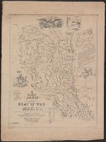
- Found in:
- Beinecke Rare Book and Manuscript Library > A correct map of the seat of war in Mexico : being a copy of Gen.l Arista's map taken at Resaca de la Palma with additions and corrections, embellished with diagrams of the battles of 8th & 9th May, and capture of Monterey, with a memorandum of forces eng
- Creator:
- Bruff, Joseph Goldsborough, 1804-1889
- Published / Created:
- 1847
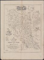
- Call Number:
- 88hc 1847A
- Container / Volume:
- BRBL_00649
- Image Count:
- 1
- Resource Type:
- Maps, Atlases & Globes
- Found in:
- Beinecke Rare Book and Manuscript Library > A correct map of the seat of war in Mexico : being a copy of Gen.l Arista's map taken at Resaca de la Palma with additions and corrections, embellished with diagrams of the battles of 8th & 9th May, and capture of Monterey, with a memorandum of forces eng
- Published / Created:
- 1804
- Call Number:
- 773 J487 1804
- Container / Volume:
- BRBL_00496
- Image Count:
- 1
- Resource Type:
- Maps, Atlases & Globes
- Found in:
- Beinecke Rare Book and Manuscript Library > A map of that part of the town of Jersey, commonly called Powles Hook / surveyed by Joseph F. Mangin.
- Creator:
- Smith, J. Calvin (John Calvin)
- Published / Created:
- 1870, c1856.
- Call Number:
- 75 1870S
- Container / Volume:
- BRBL_00404
- Image Count:
- 1
- Resource Type:
- Maps, Atlases & Globes
- Found in:
- Beinecke Rare Book and Manuscript Library > A new map for travelers through the United States of America showing the railroads, canals & stage roads with the distances / by J. Calvin Smith ; eng. on steel by Sherman & Smith, N.Y.
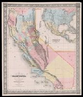
- Creator:
- Gibbes, Charles Drayton
- Published / Created:
- 1852
- Call Number:
- 844 1852A
- Container / Volume:
- BRBL_00601
- Image Count:
- 1
- Resource Type:
- Maps, Atlases & Globes
- Found in:
- Beinecke Rare Book and Manuscript Library > A new map of California / by Charles Drayton Gibbes, from his own and other recent surveys and explorations.
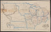
- Creator:
- Beadle, E. F
- Published / Created:
- [1856?]
- Call Number:
- 80gme 1856B
- Container / Volume:
- BRBL_00538
- Image Count:
- 1
- Resource Type:
- Maps, Atlases & Globes
- Found in:
- Beinecke Rare Book and Manuscript Library > A new map of the Great West.
- Published / Created:
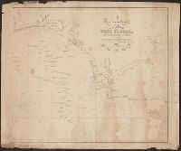
- 1823
- Call Number:
- 792cea 1823
- Container / Volume:
- BRBL_00519
- Image Count:
- 1
- Resource Type:
- Maps, Atlases & Globes
- Found in:
- Beinecke Rare Book and Manuscript Library > A particular Chart of the coasts of West Florida Louisiana Mississippi & Alabama ...
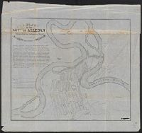
- Published / Created:
- 1836
- Call Number:
- 811 Al53 1836
- Container / Volume:
- BRBL_00553
- Image Count:
- 1
- Resource Type:
- Maps, Atlases & Globes
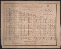
- Found in:
- Beinecke Rare Book and Manuscript Library > A plan of the city of Allegan, situated on the Kalamazoo River in the County of Allegan and Territory of Michigan.
- Creator:
- Shepard, Augustus D
- Published / Created:
- 1906
- Call Number:
- 771 Ad47 1906
- Container / Volume:
- BRBL_00480
- Image Count:
- 1
- Resource Type:
- Maps, Atlases & Globes
- Found in:
- Beinecke Rare Book and Manuscript Library > Adirondack League Club preserve / copied and developed by Augustus D. Shepard ... from the topographic sheets of the U.S. Geological Survey.
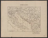
- Creator:
- American Geographical Society of New York
- Published / Created:
- [1918?]
- Call Number:
- 11hcf 1919-14
- Container / Volume:
- BRBL_00010J
- Image Count:
- 1
- Resource Type:
- Maps, Atlases & Globes
- Found in:
- Beinecke Rare Book and Manuscript Library > Adriatic [Sea region].
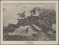
- Creator:
- Parker, Francis LeJau, 1873-1966
Spofford, Edward W
- Published / Created:
- c1914.
- Call Number:
- 30am 1914
- Container / Volume:
- BRBL_00037
- Image Count:
- 1
- Resource Type:
- Maps, Atlases & Globes
- Found in:
- Beinecke Rare Book and Manuscript Library > Aero view of Europe / [drawn by] Spofford, N.Y.
- Published / Created:
- [1869]
- Call Number:
- 321 1869
- Container / Volume:
- BRBL_00054A
- Image Count:
- 1
- Resource Type:
- Maps, Atlases & Globes
- Found in:
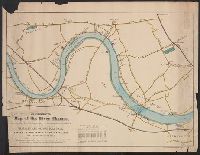
- Beinecke Rare Book and Manuscript Library > An illustrated Map of the River Thames, as compiled from the Ordnance Survey, showing the exact course of the Harvard and Oxford Boat Race. Putney to Mortlake, 4 miles, 2 Furlongs.
- Published / Created:
- 1836
- Call Number:
- 811 1836
- Container / Volume:
- BRBL_00552
- Image Count:
- 1
- Resource Type:
- Maps, Atlases & Globes
- Found in:
- Beinecke Rare Book and Manuscript Library > An improved edition of a map of the survryed part of the Territory of Michigan. by John Farmer
- Creator:
- Thomas, G. F
- Published / Created:
- [1876]
- Call Number:
- 754gme 1876
- Container / Volume:
- BRBL_00420
- Image Count:
- 2
- Resource Type:
- Maps, Atlases & Globes
- Found in:
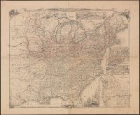
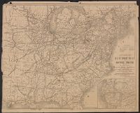
- Beinecke Rare Book and Manuscript Library > Appletons' railway map of the United States and the Canadas : representing railways in actual operation, and those in course of construction, also map of the territories, showing the Pacific Railroad, gold regions, &c. / carefully compiled by G. F. Thomas
- Creator:
- Thomas, G. F
- Published / Created:
- [1864]
- Call Number:
- 75gme 1864
- Container / Volume:
- BRBL_00412
- Image Count:
- 2
- Resource Type:
- Maps, Atlases & Globes
- Found in:
- Beinecke Rare Book and Manuscript Library > Appletons' railway map of the United States and the Canadas : representing railways in actual operation, and those in course of construction, also map of the territories, showing the Pacific Railroad, gold regions, &c. / carefully compiled by G. F. Thomas
- Published / Created:
- 1876
- Call Number:
- 766 1876A
- Container / Volume:
- BRBL_00466
- Image Count:
- 1
- Resource Type:
- Maps, Atlases & Globes
- Found in:
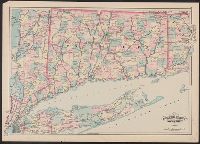
- Beinecke Rare Book and Manuscript Library > Asher & Adams' Connecticut
- Published / Created:
- 1913
- Call Number:
- 771ad N49 1913
- Container / Volume:
- BRBL_00493
- Image Count:
- 6
- Resource Type:
- Maps, Atlases & Globes
- Found in:
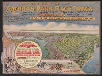
- Beinecke Rare Book and Manuscript Library > Auction sale of Morris Park race track Bronx borough New York City.
- Creator:
- American Geographical Society of New York
- Published / Created:
- [1914?]
- Call Number:
- 11hcf 1919B-13
- Container / Volume:
- BRBL_00010O
- Image Count:
- 3
- Resource Type:
- Maps, Atlases & Globes
- Found in:
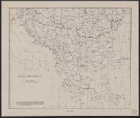
- Beinecke Rare Book and Manuscript Library > Austria-Hungary [cartographic material].
- Published / Created:
- 1909
- Call Number:
- 7715gmb 1909B
- Image Count:
- 1
- Resource Type:
- Maps, Atlases & Globes
- Found in:
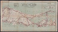
- Beinecke Rare Book and Manuscript Library > Automobile map of eastern part of Long Island / compiled by Bureau of Tours and published by the Automobile Club of America.
- Published / Created:
- c1909.
- Call Number:
- 7715gmb 1909A
- Image Count:
- 1
- Resource Type:
- Maps, Atlases & Globes
- Found in:
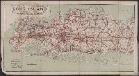
- Beinecke Rare Book and Manuscript Library > Automobile map of western part of Long Island / compiled by Bureau of Tours, Automobile Club of America.
- Creator:
- Briesemeister, William A
- Published / Created:
- [1914?]
- Call Number:
- 44ak 1914A
- Container / Volume:
- BRBL_00256
- Image Count:
- 1
- Resource Type:
- Maps, Atlases & Globes
- Found in:
- Beinecke Rare Book and Manuscript Library > Balkan peninsula / drawn by Wm. Briesemeister.
- Creator:
- American Geographical Society of New York
- Published / Created:
- [1918]
- Call Number:
- 11hcf 1919C-2
- Container / Volume:
- BRBL_00010T
- Image Count:
- 2
- Resource Type:
- Maps, Atlases & Globes
- Found in:
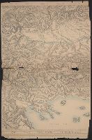
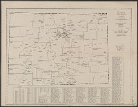
- Beinecke Rare Book and Manuscript Library > Block diagram showing terrain of the Balkan Peninsula.
- Creator:
- American Geographical Society of New York
- Published / Created:
- 1918
- Call Number:
- 11hcf 1919E
- Image Count:
- 1
- Resource Type:
- Maps, Atlases & Globes
- Found in:
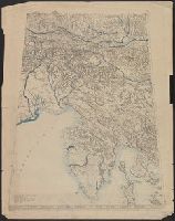
- Beinecke Rare Book and Manuscript Library > Block diagram showing terrain of the Trieste-Isonzo region.
- Published / Created:
- [ca. 1880]
- Call Number:
- 771 N49 1880A
- Container / Volume:
- BRBL_00488
- Image Count:
- 1
- Resource Type:
- Maps, Atlases & Globes
- Found in:
- Beinecke Rare Book and Manuscript Library > Bridgman's map of the suburbs of New York City embracing the territory occupied by the homes of New York businessmen.
- Published / Created:
- 1858
- Call Number:
- 811cea Sa245 1858A
- Container / Volume:
- BRBL_00554
- Image Count:
- 1
- Resource Type:
- Maps, Atlases & Globes
- Found in:
- Beinecke Rare Book and Manuscript Library > Chart of East Neebish rapids, River St. Mary : showing the improved west channel, dredged and surveyed in 1858 under the direction of Capt. A.W. Whipple, T.E. / J.H. Foster U.S. Sub. Agt., James T. Foster, draughtsman.
- Published / Created:
- [1894?]
- Call Number:
- BrSides Double Folio 2018 93
- Image Count:
- 1
- Resource Type:
- Maps, Atlases & Globes
- Found in:
- Beinecke Rare Book and Manuscript Library > Chart of the world showing distances saved by the interoceanic canal of Nicaragua and Costa Rica [cartographic material].
- Creator:
- H.H. Lloyd & Co
- Published / Created:
- c1858.
- Call Number:
- 21gmh 1858
- Image Count:
- 1
- Resource Type:
- Maps, Atlases & Globes
- Found in:
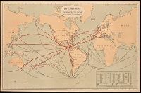
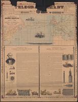
- Beinecke Rare Book and Manuscript Library > Chart showing the track of the great submarine Atlantic telegraph : with the principal land & submarine telegraph lines in Europe & America, also the tracks of steamships, and the depth of the ocean.
- Published / Created:
- 1834
- Call Number:
- 806gmb C43 1834
- Container / Volume:
- BRBL_00549
- Image Count:
- 1
- Resource Type:
- Maps, Atlases & Globes
- Found in:
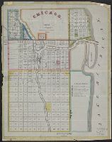
- Beinecke Rare Book and Manuscript Library > Chicago. Drwn by J.S.Wright, according to survey.
- Creator:
- Hobbs, C. W
- Published / Created:
- 1880
- Call Number:
- 771 N49 1880
- Container / Volume:
- BRBL_00488
- Image Count:
- 1
- Resource Type:
- Maps, Atlases & Globes
- Found in:
- Beinecke Rare Book and Manuscript Library > Citizens & travelers guide map into and from the City of New York and adjacent places.
- Published / Created:
- 1833
- Call Number:
- 771 N49 1833
- Container / Volume:
- BRBL_00485
- Image Count:
- 1
- Resource Type:
- Maps, Atlases & Globes
- Found in:
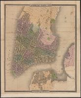
- Beinecke Rare Book and Manuscript Library > City of New York, by David H. Burr.
- Creator:
- American Map Company (New York, N.Y.)
- Published / Created:
- [1931].
- Call Number:
- 834 1931A
- Container / Volume:
- BRBL_00588
- Image Count:
- 1
- Resource Type:
- Maps, Atlases & Globes
- Found in:
- Beinecke Rare Book and Manuscript Library > Cleartype county-town map of Colorado.
- Published / Created:
- [1854?]
- Call Number:
- 35311hc Se21 1854A
- Container / Volume:
- BRBL_00112
- Image Count:
- 1
- Resource Type:
- Maps, Atlases & Globes
- Found in:
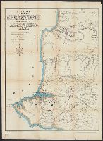
- Beinecke Rare Book and Manuscript Library > Collins' environs of Sebastopol : showing the position of the investing armies and also the plan of the Battle-field of Alma / drawn from the most recent surveys by F. Raverstow.
- Creator:
- Colton, J. H. (Joseph Hutchins), 1800-1893
- Published / Created:
- [1855?]
- Call Number:
- 844 1855B
- Container / Volume:
- BRBL_00601
- Image Count:
- 2
- Resource Type:
- Maps, Atlases & Globes
- Found in:
- Beinecke Rare Book and Manuscript Library > Colton's California.
- Creator:
- G.W. & C.B. Colton & Co
- Published / Created:
- 1878, c1855.
- Call Number:
- 766 1878
- Container / Volume:
- BRBL_00466
- Image Count:
- 1
- Resource Type:
- Maps, Atlases & Globes
- Found in:
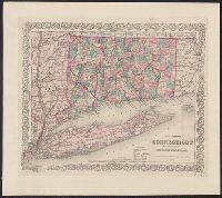
- Beinecke Rare Book and Manuscript Library > Colton's Connecticut : with portions of New York & Rhode Island.
- Creator:
- G.W. & C.B. Colton & Co
- Published / Created:
- 1868
- Call Number:
- 766 1868
- Container / Volume:
- BRBL_00466
- Image Count:
- 1
- Resource Type:
- Maps, Atlases & Globes
- Found in:
- Beinecke Rare Book and Manuscript Library > Colton's Connecticut : with portions of New York & Rhode Island.
- Creator:
- G.W. & C.B. Colton & Co
- Published / Created:
- [1884]
- Call Number:
- 761 1884
- Container / Volume:
- BRBL_00447
- Image Count:
- 1
- Resource Type:
- Maps, Atlases & Globes
- Found in:
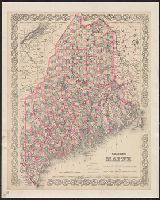
- Beinecke Rare Book and Manuscript Library > Colton's Maine / published by G.W. and C.B. Colton & Co.
- Published / Created:
- 1858
- Call Number:
- 11 1858
- Container / Volume:
- BRBL_00009
- Image Count:
- 1
- Resource Type:
- Maps, Atlases & Globes
- Found in:
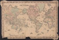
- Beinecke Rare Book and Manuscript Library > Colton's Map of the World on Mercator's Projection.
- Creator:
- Colton, J. H. (Joseph Hutchins), 1800-1893
- Published / Created:
- 1860
- Call Number:
- 764 1860
- Container / Volume:
- BRBL_00453
- Image Count:
- 1
- Resource Type:
- Maps, Atlases & Globes
- Found in:
- Beinecke Rare Book and Manuscript Library > Colton's Massachusetts and Rhode Island.
- Creator:
- G.W. & C.B. Colton & Co.
- Published / Created:
- 1866
- Call Number:
- 773 1866
- Container / Volume:
- BRBL_00495
- Image Count:
- 1
- Resource Type:
- Maps, Atlases & Globes
- Found in:
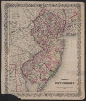
- Beinecke Rare Book and Manuscript Library > Colton's New Jersey [cartographic material].
- Creator:
- G.W. & C.B. Colton & Co.
- Published / Created:
- 1855
- Call Number:
- BrSides Folio 2019 9
- Image Count:
- 1
- Resource Type:
- Maps, Atlases & Globes
- Found in:
- Beinecke Rare Book and Manuscript Library > Colton's North Carolina [cartographic material].
- Creator:
- G.W. & C.B. Colton & Co
- Published / Created:
- [1884?], c1883.
- Call Number:
- 7855 1883
- Container / Volume:
- BRBL_00515
- Image Count:
- 1
- Resource Type:
- Maps, Atlases & Globes
- Found in:
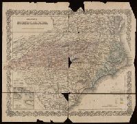
- Beinecke Rare Book and Manuscript Library > Colton's North Carolina and South Carolina.
- Creator:
- G.W. & C.B. Colton & Co
- Published / Created:
- 1879
- Call Number:
- 846 1879
- Container / Volume:
- BRBL_00621
- Image Count:
- 1
- Resource Type:
- Maps, Atlases & Globes
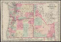
- Found in:
- Beinecke Rare Book and Manuscript Library > Colton's Oregon, Washington, and Idaho / G.W. and C.B. Colton & Company.