Skip to search
Skip to main content
Skip to first result
Search
You Searched For
Repository
Beinecke Rare Book and Manuscript Library
Genre
Maps
Publication Place
New York :
New Search
Search Results
Published / Created:
1804
Call Number:
773 J487 1804
Container / Volume:
BRBL_00496
Image Count:
1
Resource Type:
Maps, Atlases & Globes
Publisher:
P. Desobry,
Subject (Geographic):
New Jersey--Maps
Found in:
Beinecke Rare Book and Manuscript Library > A map of that part of the town of Jersey, commonly called Powles Hook / surveyed by Joseph F. Mangin.
Creator:
Published / Created:
1870, c1856.
Call Number:
75 1870S
Container / Volume:
BRBL_00404
Image Count:
1
Resource Type:
Maps, Atlases & Globes
Description:
Insets: Railroad & canal routes from Albany to Buffalo -- Map showing the rail roads between the cities of New York, Boston & Albany and the Hudson R. from N. York to Albany -- Rail road route from New York to Philadelphia -- Rail road route from Philadel
Publisher:
J. Disturnell,
Subject (Geographic):
United States--Maps
Subject (Name):
Disturnell, John, 1801-1877 and Sherman & Smith
Found in:
Beinecke Rare Book and Manuscript Library > A new map for travelers through the United States of America showing the railroads, canals & stage roads with the distances / by J. Calvin Smith ; eng. on steel by Sherman & Smith, N.Y.
Creator:
Published / Created:
1852
Call Number:
844 1852A
Container / Volume:
BRBL_00601
Image Count:
1
Resource Type:
Maps, Atlases & Globes
Alternative Title:
Gibbes' map of the state of California and Map of the United States of America, Mexico, Central America, Cuba &c.
Description:
Inset: Map of the United States of America, Mexico, Central America, Cuba &c. Scale [ca. 1:13,000,000] (W 128⁰--W 65⁰/N 49⁰--N 6⁰)., Presentation inscription: Charles D Gibbes [rubber stamped] to George Davidson, Jany 11/87., and Prime meridians: Greenwich and Washington.
Publisher:
C.D. Gibbes : and Sherman & Smith,
Subject (Geographic):
California--Maps
Subject (Name):
Davidson, George,--1825-1911.--Presentation inscription from C.D. Gibbes, Gibbes, Charles Drayton.--Presentation inscription to G. Davidson, and Sherman & Smith
Found in:
Beinecke Rare Book and Manuscript Library > A new map of California / by Charles Drayton Gibbes, from his own and other recent surveys and explorations.
Creator:
Published / Created:
[1856?]
Call Number:
80gme 1856B
Container / Volume:
BRBL_00538
Image Count:
1
Resource Type:
Maps, Atlases & Globes
Publisher:
Miller, Orton & Mulligan,
Subject (Geographic):
Middle West--Maps and United States--Maps
Found in:
Beinecke Rare Book and Manuscript Library > A new map of the Great West.
Published / Created:
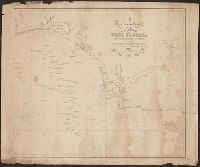
1823
Call Number:
792cea 1823
Container / Volume:
BRBL_00519
Image Count:
1
Resource Type:
Maps, Atlases & Globes
Publisher:
Richard Pattern,
Subject (Geographic):
Florida--Maps
Found in:
Beinecke Rare Book and Manuscript Library > A particular Chart of the coasts of West Florida Louisiana Mississippi & Alabama ...
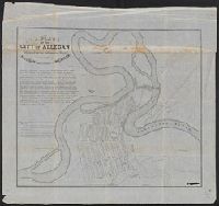
Published / Created:
1836
Call Number:
811 Al53 1836
Container / Volume:
BRBL_00553
Image Count:
1
Resource Type:
Maps, Atlases & Globes
Publisher:
P.A.Mesier's Lith.,
Subject (Geographic):
Allegan County (Mich.)--Maps
Found in:
Beinecke Rare Book and Manuscript Library > A plan of the city of Allegan, situated on the Kalamazoo River in the County of Allegan and Territory of Michigan.
Creator:
Published / Created:
1906
Call Number:
771 Ad47 1906
Container / Volume:
BRBL_00480
Image Count:
1
Resource Type:
Maps, Atlases & Globes
Description:
Includes continuation inset of "Road from Forestport Station to Reeds Mill." and Relief shown by contours and spot heights.
Publisher:
A.R. Ohman Map Co.,
Subject (Geographic):
Adirondack Mountains (N.Y.)--Maps and Adirondack Park (N.Y.)--Maps
Subject (Topic):
Adirondack League Club
Found in:
Beinecke Rare Book and Manuscript Library > Adirondack League Club preserve / copied and developed by Augustus D. Shepard ... from the topographic sheets of the U.S. Geological Survey.
Creator:
Published / Created:
[1918?]
Call Number:
11hcf 1919-14
Container / Volume:
BRBL_00010J
Image Count:
1
Resource Type:
Maps, Atlases & Globes
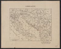
Description:
Ms. notes showing Italian land claims following World War I.
Publisher:
American Geographical Society,
Subject (Geographic):
Adriatic Sea Region--Maps
Subject (Topic):
World War, 1914-1918--Maps
Found in:
Beinecke Rare Book and Manuscript Library > Adriatic [Sea region].
Creator:
Published / Created:
c1914.
Call Number:
30am 1914
Container / Volume:
BRBL_00037
Image Count:
1
Resource Type:
Maps, Atlases & Globes
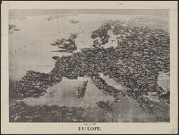
Alternative Title:
Literary digest (New York, N.Y. : 1890)
Description:
"Copyright 1914-E.W. Spofford ... New York.", Panorama as if from outer space., Relief shown by shading., and Removed from the Francis LeJau Parker papers in LC Manuscript Division.
Publisher:
Literary digest,
Subject (Geographic):
Europe--Aerial views
Found in:
Beinecke Rare Book and Manuscript Library > Aero view of Europe / [drawn by] Spofford, N.Y.
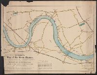
Published / Created:
[1869]
Call Number:
321 1869
Container / Volume:
BRBL_00054A
Image Count:
1
Resource Type:
Maps, Atlases & Globes
Description:
Table of previous boat races.
Publisher:
Aug D. White,
Subject (Geographic):
River Thames (England)--Maps
Found in:
Beinecke Rare Book and Manuscript Library > An illustrated Map of the River Thames, as compiled from the Ordnance Survey, showing the exact course of the Harvard and Oxford Boat Race. Putney to Mortlake, 4 miles, 2 Furlongs.
Branch:v1.61.6 ,Deployed:2024-06-12T09:55:37-04:00