"Entered according to act of Congress in the year 1855 by J.H. Colton in the clerks office of the district court for the southern district of New York.", "No. 52.", Includes inset of "City of San Francisco.", Relief shown by hachures and spot heights., and Text on verso: The territories of Oregon and Washington.
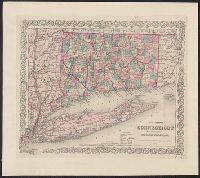
Includes key to symbols. and Includes Long Island and adjoining portions of Massachusetts, Rhode Island, and New York, including the Hudson River Valley northward to Malden.
Publisher:
G. W. and C. B. Colton,
Subject (Geographic):
Connecticut--Maps, Hudson River Valley--Maps, Long Island (N.Y.)--Maps, New York (State)--Maps, and Rhode Island--Maps
1 inch = ca. 10 miles., Advertisement for their maps, on front pastedown., Colored by town; borders of counties and of states in red., and In brown cloth covered folder, with "Colton's Map of Connecticut" and publisher's name in gold, surrounded by curvilinear d
Publisher:
G.W. and C.B. Colton,
Subject (Geographic):
Connecticut--Maps, Long Island (N.Y.)--Maps, and New York (State)--Maps
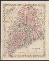
"Entered according to Act of Congress in the year 1884 by G.W. & C.B. Colton & Co. in the office of the Librarian of Congress at Washington.", From Maine state year-book and annual register, for the year 1884., and Shows county, town, and unincorporated townshi
"Entered according to Act of Congress in the Year 1855 by J.H. Colton & Co. in the Clerks Office of the District Court of the United States for the Southern District of New York.", Inset: Vicinity of Boston. Scale [ca. 1:195,000]., and Prime meridians: Greenwic
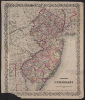
"Entered according to Act of Congress in the year 1855 ... for the Southern District of New York.", Hand colored by township; counties outlined in red. Map within decorative border., Indicates railroads, canals, and roads., and Prime meridians: Greenwich and Was
Publisher:
G.W. and C.B. Colton,
Subject (Geographic):
New Jersey and New Jersey--Maps.
Subject (Name):
Colton, G. Woolworth (George Woolworth), 1827-1901 and Colton, J. H. (Joseph Hutchins), 1800-1893
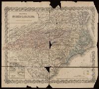
"Entered according to act of Congress in the 1855 by J.H. Colton & Co. ... for the Southern District of New York.", Imperfect: chipped and torn., Inset: Beaufort Harbor., Prime meridians: Greenwich and Washington., Relief shown by hachures and spot heights., and Shows counties, cities and towns, principal roads, railroads, and natural features. Colored to show tree types and mineral resources.
Publisher:
G.W. & C.B. Colton,
Subject (Geographic):
Beaufort (N.C.)--Maps, North Carolina--Beaufort, and North Carolina--Maps
Subject (Name):
J.H. Colton & Co
Subject (Topic):
Coal mines and mining--North Carolina--Maps, Copper mines and mining--North Carolina--Maps, Forests and forestry--North Carolina--Maps, Gold mines and mining--North Carolina--Maps, and Iron mines and mining--North C
"Entered according to Act of Congress in the year 1883 by G.W. & C.B. Colton ...", In upper left and right margins: No. 45, No. 46., Includes 2 insets: Beaufort Harbor -- Plan of Charleston, vicinity and harbor., Relief shown by hachures and spot heights., and Sh
Publisher:
G.W. and C.B. Colton & Co.,
Subject (Geographic):
North Carolina--Maps and South Carolina--Maps
Subject (Name):
Colton, G. Woolworth (George Woolworth), 1827-1901 and Kerr, Washington Caruthers, 1827-1885
Subject (Topic):
Railroads--North Carolina--Maps and Railroads--South Carolina--Maps
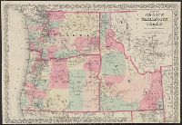
"Entered according to act of Congress in the year 1876 by G.W. & C.B. Colton ....", Also covers southwestern Montana., Prime meridians: Greenwich and Washington., Relief shown by hachures., and Shows counties, railroads, camps, and Indian reservations.
Publisher:
G.W. and C.B. Colton,
Subject (Geographic):
Northwest, Pacific--Maps
Subject (Topic):
Indians of North America--Northwest, Pacific--Maps, Military bases--Northwest, Pacific--Maps, and Railroads--Northwest, Pacific--Maps