Skip to search
Skip to main content
Skip to first result
Search
You Searched For
Access
Public
Genre
Maps
Publication Place
New York :
Subject (Geographic)
France--Maps
New Search
Search Results
Creator:
Published / Created:
1865
Call Number:
38 1866
Container / Volume:
BRBL_00154
Image Count:
2
Resource Type:
Maps, Atlases & Globes
Description:
Insets: Corsica -- Gibraltar Rock. and Relief indicated by hachures.
Publisher:
Johnson,
Subject (Geographic):
France--Maps and Iberian Peninsula--Maps
Found in:
Beinecke Rare Book and Manuscript Library > Johnson's France Spain and Portugal [cartographic material].
Creator:
Published / Created:
[c1917]
Call Number:
11hc 1917B
Container / Volume:
BRBL_00010D
Image Count:
2
Resource Type:
Maps, Atlases & Globes
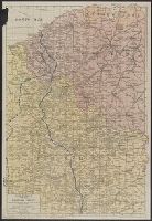
Description:
In lower right corner: "For continuation of "French Front" South, see Section No. 2." and Index on verso.
Publisher:
Rand McNally and Co.,
Subject (Geographic):
Belgium--Maps and France--Maps
Subject (Topic):
World War, 1914-1918--Campaigns--Maps
Found in:
Beinecke Rare Book and Manuscript Library > Rand McNally war map of the British front : a strategic map of of the battleground in Belgium and northern France, from Ostend to St. Quentin / compiled from the latest military maps of the army staffs in Washington, London and Paris, and from other offic
Creator:
Published / Created:
[1918]
Call Number:
11hc 1917C
Container / Volume:
BRBL_00010D
Image Count:
2
Resource Type:
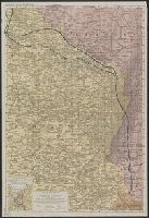
Maps, Atlases & Globes
Alternative Title:
War map of the French front.
Description:
In lower right corner: "For continuation of "French Front" South, see Section No. 3.", Includes legend., Index on verso of map., and Inset: General war map.
Publisher:
The Company,
Subject (Geographic):
France--Maps
Subject (Topic):
World War, 1914-1918--France--Maps
Found in:
Beinecke Rare Book and Manuscript Library > Rand McNally war map of the French front : northern section : strategic map of the battle ground in northern France from St. Quentin to St. Mihiel, showing the farthest advance of the Germans in 1914 and the battle line in September, 1917.
Creator:
Published / Created:
[1918?]
Call Number:
11hc 1917D
Container / Volume:
BRBL_00010D
Image Count:
2
Resource Type:
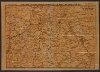
Maps, Atlases & Globes
Alternative Title:
War map of the French front
Description:
Index on verso of map. and Relief shown by hachures.
Publisher:
The Company,
Subject (Geographic):
France--Maps
Subject (Topic):
World War, 1914-1918--France--Maps
Found in:
Beinecke Rare Book and Manuscript Library > Rand McNally war map of the French front : southern section : strategic map of the battle ground in northern France from St. Mihiel to the Swiss border / compiled from the latest military maps of the army staffs in Washington, London, and Paris, and from
Published / Created:
1918
Call Number:
11hc 1918F
Container / Volume:
BRBL_00010E
Image Count:
2
Resource Type:
Maps, Atlases & Globes
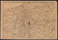
Alternative Title:
The New York Times War Map.
Description:
"Sunday, January 27, 1918." and Verso: Photographs of "American War Activities on Both Sides of the Atlantic."
Publisher:
C.S. Hammond & Co.,
Subject (Geographic):
Belgium--Maps and France--Maps
Found in:
Beinecke Rare Book and Manuscript Library > The Fifth of five sections making up the New York Times war map.
Published / Created:
1918
Call Number:
11hc 1918G
Container / Volume:
BRBL_00010E
Image Count:
2
Resource Type:
Maps, Atlases & Globes
Alternative Title:
The New York Times War Map.
Description:
"Sunday, January 20, 1918." and Verso: Photographs of arts and cultural events and the first World War.
Publisher:
C.S. Hammond & Co.,
Subject (Geographic):
Belgium--Maps and France--Maps
Found in:
Beinecke Rare Book and Manuscript Library > The Fourth of five sections making up the New York Times war map.
Branch:v1.61.6 ,Deployed:2024-06-12T09:55:36-04:00