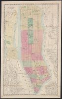
Covers all of Manhattan, also the westernmost parts of Queens and Brooklyn in New York (N.Y.); also part of Jersey City and Hoboken in Hudson County (N.J.) New York (N.Y.) Map shows railroads, shows and names piers. and Hand col.
Publisher:
M. Dripps,
Subject (Geographic):
Hudson County (N.J.), Manhattan (New York, N.Y.)--Maps, and New York (N.Y.)--Maps
Subject (Topic):
Piers--New York (State)--New York--Maps and Railroads--New York (State)--New York--Maps
Lithographed map colored to show conflagration sections (by red numerals), normal, bad, and very bad blocks, proposed hydrants and companies, present companies, etc. Also shows city blocks, engine ladder, hose, chemical, water tower, fire-boat companies, etc.
Lithograph showing present mains 10" in diameter or larger, Mains 12" or larger proposed or under construction by water dept. Arteries proposed by National Board for immediate installation. Serial Nos. indicate location of hydrant tests. Colored to show areas of static pressures at hydrants as observed by National Board Engineers between 9 A.M. and 5 P.M.
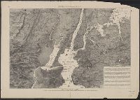
"Entered, according to Act of Congress, in the year 1857, by Humphrey Phelps, in ... the Southern District of New York.", Includes index., Oriented with north to the upper right., and Relief shown by hachures.