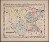
"Entered accoding [sic] to Act of Congress in the year 1855, by J.H. Colton & Co. in ... the Southern District of New York.", Covers Minnesota Territory, extending to White Earth and Missouri rivers to the west., In lower right margin: No. 49., and Includes note.
Publisher:
J. H. Colton & Co.,
Subject (Geographic):
Minnesota--Maps, North Dakota--Maps, and South Dakota--Maps
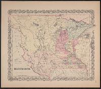
"Entered according to Act of Congress in the year 1855, by J.H. Colton & Co. ...", Covers Minnesota Territory, including Pembina, and the Yankton, Yanktonnan and Chippewa areas, with Missouri River and White Earth River as western boundary., and In bottom right margin: No. 49.
Publisher:
J.H. Colton & Co.,
Subject (Geographic):
Minnesota--Maps, North Dakota--Maps, and South Dakota--Maps
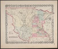
"Entered according to Act of Congress in the year 1855, by J.H. Colton & Co. ...", Appears in Colton's atlas of the world. New York: J.H. Colton & Co., 1855-56., and Covers Minnesota Territory, including Pembina, and the Yankton, Yanktonnan and Chippewa areas, with Missouri River and White Earth River as western boundary.
Publisher:
J.H. Colton & Co.,
Subject (Geographic):
Minnesota--Maps, North Dakota--Maps, and South Dakota--Maps
Subject (Name):
Colton, G. Woolworth (George Woolworth), 1827-1901. Colton's atlas of the world
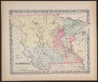
"Entered according to Act of Congress in the year 1855, by J.H. Colton & Co. ...", Accompanied by text: The territory of Minnesota. 1 leaf ; 48 cm., and Covers Minnesota Territory, including Pembina, and the Yankton, Yanktonnan and Chippewa areas, with Missouri River and White Earth River as western boundary.
Publisher:
J.H. Colton & Co.,
Subject (Geographic):
Minnesota--Maps, North Dakota--Maps, and South Dakota--Maps