Search
You Searched For
Search Results
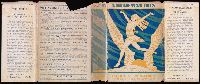
- Creator:
- Tyler, Parker.
- Published / Created:
- [1963]
- Call Number:
- Za St4666 +S963T
- Image Count:
- 1
- Resource Type:
- Books, Journals & Pamphlets
- Found in:
- Beinecke Rare Book and Manuscript Library > Florine Stettheimer, a life in art / by Parker Tyler.
- Creator:
- Marks, Percy, 1891-
- Published / Created:
- c1929.
- Call Number:
- Za M344 929D
- Image Count:
- 1
- Resource Type:
- Books, Journals & Pamphlets
- Found in:
- Beinecke Rare Book and Manuscript Library > A dead man dies / by Percy Marks.
- Published / Created:
- c1992.
- Call Number:
- 2009 Folio S10 6
- Image Count:
- 1
- Resource Type:
- Books, Journals & Pamphlets
- Found in:
- Beinecke Rare Book and Manuscript Library > Visionaire. No. 6 : summer 1992. The sea / by Stephen Gan, James Kaliardos, Cecila Dean ... Thanks to ... Gregory Foley ...
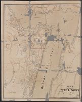
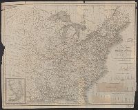
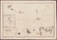
- Call Number:
- 771 W528 1867
- Container / Volume:
- BRBL_00492
- Image Count:
- 1
- Resource Type:
- Maps, Atlases & Globes
- Found in:
- Beinecke Rare Book and Manuscript Library > Map of West Point.
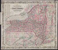
- Creator:
- Colton, G. Woolworth (George Woolworth), 1827-1901
- Call Number:
- 771 1869C
- Container / Volume:
- BRBL_00479
- Image Count:
- 1
- Resource Type:
- Maps, Atlases & Globes
- Found in:
- Beinecke Rare Book and Manuscript Library > Colton's railroad & township map of the state of New York : with parts of the adjoining states & Canada / drawn by Geo. W. Colton ; J.M. Atwood, sculpt.
- Call Number:
- Bailey S343
- Image Count:
- 1
- Found in:
- Beinecke Rare Book and Manuscript Library > Sexology
- Published / Created:
- [n.d.]
- Call Number:
- WC 13991
- Image Count:
- 54
- Found in:
- Beinecke Rare Book and Manuscript Library > Sad tale of the courtship of Chevalier Slyfox-Wikof, showing his heart-rending, astounding & most wonderful love adventures with Fanny Elssler and Miss Gambol. With near 200 comic engravings.
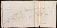
- Published / Created:
- 1795
- Call Number:
- 802 1795B
- Container / Volume:
- BRBL_00542
- Image Count:
- 1
- Resource Type:
- Maps, Atlases & Globes
- Found in:
- Beinecke Rare Book and Manuscript Library > Map of the State of Kentucky; with the Adjointing Territories.
- Published / Created:
- 1795
- Call Number:
- 777 1795A
- Container / Volume:
- BRBL_00503
- Image Count:
- 1
- Resource Type:
- Maps, Atlases & Globes
- Found in:
- Beinecke Rare Book and Manuscript Library > The States of Maryland and Delaware from the latest Surveys.
- Published / Created:
- 1796
- Call Number:
- 90 1796
- Container / Volume:
- BRBL_00661
- Image Count:
- 1
- Resource Type:
- Maps, Atlases & Globes
- Found in:
- Beinecke Rare Book and Manuscript Library > A General Map Of South America. from the Best Surveys.
- Published / Created:
- 1796
- Call Number:
- 783 1796A
- Container / Volume:
- BRBL_00507
- Image Count:
- 1
- Resource Type:
- Maps, Atlases & Globes
- Found in:
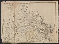
- Beinecke Rare Book and Manuscript Library > The State of Virginia from the best Authorities.
- Published / Created:
- [1796?]
- Call Number:
- 763 1796B
- Container / Volume:
- BRBL_00452
- Image Count:
- 1
- Resource Type:
- Maps, Atlases & Globes
- Found in:
- Beinecke Rare Book and Manuscript Library > Vermont from the latest Authorities.
- Published / Created:
- 1796
- Call Number:
- 762 1796A
- Container / Volume:
- BRBL_00450
- Image Count:
- 1
- Resource Type:
- Maps, Atlases & Globes
- Found in:
- Beinecke Rare Book and Manuscript Library > The State of New Hampshire, Compiled chiefly from Actual Surveys.
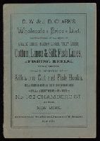
- Creator:
- D.W. & J.D. Clark (Firm)
- Published / Created:
- [18--?]
- Call Number:
- 1984 80
- Image Count:
- 14
- Found in:
- Beinecke Rare Book and Manuscript Library > D.W. & J.D. Clark's wholesale price list : manufacturers of all kinds of cotton, linen & silk fish lines, chark lines, mason lines, trot lines, fishing reels of every description, and importers of silkworm, cut and fish hooks ...
- Published / Created:
- 1804
- Call Number:
- 773 J487 1804
- Container / Volume:
- BRBL_00496
- Image Count:
- 1
- Resource Type:
- Maps, Atlases & Globes
- Found in:
- Beinecke Rare Book and Manuscript Library > A map of that part of the town of Jersey, commonly called Powles Hook / surveyed by Joseph F. Mangin.
- Published / Created:
- [1804?]
- Call Number:
- 771 1804
- Container / Volume:
- BRBL_00477
- Image Count:
- 1
- Resource Type:
- Maps, Atlases & Globes
- Found in:
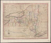
- Beinecke Rare Book and Manuscript Library > Map of the State of New York by Simeon DeWitt, Surveyor General ...
- Published / Created:
- 1814
- Call Number:
- Shirley 1276
- Image Count:
- 1
- Found in:
- Beinecke Rare Book and Manuscript Library > Summer
- Published / Created:
- 1815
- Call Number:
- 771 1815
- Container / Volume:
- BRBL_00478
- Image Count:
- 1
- Resource Type:
- Maps, Atlases & Globes
- Found in:
- Beinecke Rare Book and Manuscript Library > Map of the Southern part of the State of New York including Long Island, the Sound, the State of Connecticut part of the State of New Jersey and Island's adjacent. Compiled from actual surveys.
- Creator:
- Tanesse, I
- Published / Created:
- 1817
- Call Number:
- 795 N47 1817
- Container / Volume:
- BRBL_00522
- Image Count:
- 1
- Resource Type:
- Maps, Atlases & Globes
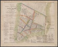
- Found in:
- Beinecke Rare Book and Manuscript Library > Plan of the city and suburbs of New Orleans : from an actual survey made in 1815 / by I. Tanesse ; Rollinson, sc.
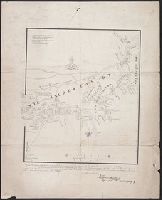
- Creator:
- Day, Thomas, 1748-1789
- Published / Created:
- 1819
- Call Number:
- Is94 t1 2
- Image Count:
- 2
- Found in:
- Beinecke Rare Book and Manuscript Library > The forsaken infant, or, Entertaining history of Little Jack.
- Published / Created:
- 1823
- Call Number:
- 85 1492
- Container / Volume:
- BRBL_00636
- Image Count:
- 1
- Resource Type:
- Maps, Atlases & Globes
- Found in:
- Beinecke Rare Book and Manuscript Library > Map of The Route of Colombus on arriving among the Bahama Islands. Plan by D.G. Johnson
- Published / Created:
- 1823
- Call Number:
- 85 1492
- Container / Volume:
- BRBL_00636
- Image Count:
- 1
- Resource Type:
- Maps, Atlases & Globes
- Found in:
- Beinecke Rare Book and Manuscript Library > Map of The Route of Colombus on arriving among the Bahama Islands. Plan by D.G. Johnson
- Published / Created:
- 1823
- Call Number:
- 792cea 1823
- Container / Volume:
- BRBL_00519
- Image Count:
- 1
- Resource Type:
- Maps, Atlases & Globes
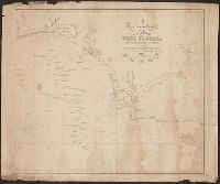
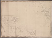
- Found in:
- Beinecke Rare Book and Manuscript Library > A particular Chart of the coasts of West Florida Louisiana Mississippi & Alabama ...
- Published / Created:
- 1825
- Call Number:
- 23cea 1825
- Container / Volume:
- BRBL_00021
- Image Count:
- 2
- Resource Type:
- Maps, Atlases & Globes
- Found in:
- Beinecke Rare Book and Manuscript Library > A Chart of the West Coast of America ... from the latest Spanish surveys. Engraved by J.M. Taylor, NY.
- Published / Created:
- 1825
- Call Number:
- 21cea 1825
- Container / Volume:
- BRBL_00016
- Image Count:
- 1
- Resource Type:
- Maps, Atlases & Globes
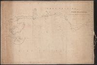
- Found in:
- Beinecke Rare Book and Manuscript Library > The Coasts of West Florida, Alabama, Mississippi & Louisiana ...
- Published / Created:
- 1826
- Call Number:
- 75 1826B
- Container / Volume:
- BRBL_00398
- Image Count:
- 1
- Resource Type:
- Maps, Atlases & Globes
- Found in:
- Beinecke Rare Book and Manuscript Library > Map of the United States : drawn from the most approved surveys.
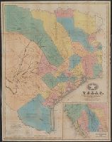
- Creator:
- Hooker, William, 1782-1856
- Call Number:
- 771 N49 1828
- Container / Volume:
- BRBL_00485
- Image Count:
- 1
- Resource Type:
- Maps, Atlases & Globes
- Found in:
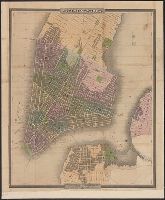
- Beinecke Rare Book and Manuscript Library > Hooker's new pocket plan of the city of New York / compiled & surveyed by William Hooker, A.C.S.A., hydrographer & engraver.
- Published / Created:
- 1829
- Call Number:
- 771 W25 1829
- Container / Volume:
- BRBL_00492
- Image Count:
- 1
- Resource Type:
- Maps, Atlases & Globes
- Found in:
- Beinecke Rare Book and Manuscript Library > Map of the county of Warren [NY].
- Published / Created:
- 1829
- Call Number:
- 771 Sa71 1829
- Container / Volume:
- BRBL_00491
- Image Count:
- 1
- Resource Type:
- Maps, Atlases & Globes
- Found in:
- Beinecke Rare Book and Manuscript Library > Map of the County of Saratoga [NY].
- Published / Created:
- 1829
- Call Number:
- 771 OT7 1829A
- Container / Volume:
- BRBL_00490
- Image Count:
- 1
- Resource Type:
- Maps, Atlases & Globes
- Found in:
- Beinecke Rare Book and Manuscript Library > Map of the County of Otsego. By David H. Burr. Published by the Surveyor General pursuant to an act of the Legislature.
- Published / Created:
- 1829
- Call Number:
- 771 OT7 1829
- Container / Volume:
- BRBL_00490
- Image Count:
- 1
- Resource Type:
- Maps, Atlases & Globes
- Found in:
- Beinecke Rare Book and Manuscript Library > Map of the County of Otsego [N.Y.].
- Published / Created:
- 1829
- Call Number:
- 771 OS9 1829
- Container / Volume:
- BRBL_00490
- Image Count:
- 1
- Resource Type:
- Maps, Atlases & Globes
- Found in:
- Beinecke Rare Book and Manuscript Library > Map of the County of Oswego [N.Y.].
- Published / Created:
- 1829
- Call Number:
- 771 ON6 1829
- Container / Volume:
- BRBL_00490
- Image Count:
- 1
- Resource Type:
- Maps, Atlases & Globes
- Found in:
- Beinecke Rare Book and Manuscript Library > Map of the County of Onondaga [N.Y.]
- Published / Created:
- 1829
- Call Number:
- 771 On2 1829
- Image Count:
- 1
- Resource Type:
- Maps, Atlases & Globes
- Found in:
- Beinecke Rare Book and Manuscript Library > Map of the County of Oneida [N.Y.].
- Creator:
- Poppleton, Thomas H.
- Call Number:
- 771 N49 1829
- Container / Volume:
- BRBL_00485
- Image Count:
- 1
- Resource Type:
- Maps, Atlases & Globes
- Found in:
- Beinecke Rare Book and Manuscript Library > Plan of the city of New-York : the greater part from actual survey made expressly for the purpose (the rest from authentic documents) / by Thos. H. Poppleton, city surveyor ; revised & corrected by Wm. Hooker ; P. Maverick sc. Newark.
- Published / Created:
- 1829
- Call Number:
- 771 M766 1829
- Container / Volume:
- BRBL_00483
- Image Count:
- 1
- Resource Type:
- Maps, Atlases & Globes
- Found in:
- Beinecke Rare Book and Manuscript Library > Map of the County of Montgomery [N.Y.]
- Published / Created:
- 1829
- Call Number:
- 771 M26 1829
- Container / Volume:
- BRBL_00483
- Image Count:
- 1
- Resource Type:
- Maps, Atlases & Globes
- Found in:
- Beinecke Rare Book and Manuscript Library > Map of the County of Madison, N.Y.
- Published / Created:
- 1829
- Call Number:
- 771 L58 1829
- Container / Volume:
- BRBL_00483
- Image Count:
- 1
- Resource Type:
- Maps, Atlases & Globes
- Found in:
- Beinecke Rare Book and Manuscript Library > Map of the County of Lewis [N.Y.]
- Published / Created:
- 1829
- Call Number:
- 771 H425 1829
- Container / Volume:
- BRBL_00483
- Image Count:
- 1
- Resource Type:
- Maps, Atlases & Globes
- Found in:
- Beinecke Rare Book and Manuscript Library > Map of the county of Herkimer [N.Y.]
- Published / Created:
- [1829?]
- Call Number:
- 771 G29 1777
- Container / Volume:
- BRBL_00482A
- Image Count:
- 1
- Resource Type:
- Maps, Atlases & Globes
- Found in:
- Beinecke Rare Book and Manuscript Library > Map of Lake George.
- Published / Created:
- 1829
- Call Number:
- 771 C42 1829
- Container / Volume:
- BRBL_00482
- Image Count:
- 1
- Resource Type:
- Maps, Atlases & Globes
- Found in:
- Beinecke Rare Book and Manuscript Library > Map of the County of Chenango [N.Y.]
- Published / Created:
- 1829
- Call Number:
- 771 C31 1829
- Container / Volume:
- BRBL_00482
- Image Count:
- 1
- Resource Type:
- Maps, Atlases & Globes
- Found in:
- Beinecke Rare Book and Manuscript Library > Map of the County of Cayuga [N.Y.]
- Published / Created:
- 1829
- Call Number:
- 771 B798 1829
- Container / Volume:
- BRBL_00481
- Image Count:
- 1
- Resource Type:
- Maps, Atlases & Globes
- Found in:
- Beinecke Rare Book and Manuscript Library > Map of the county of Broome [N.Y.] By David H. Burr.
- Creator:
- E. & G.W. Blunt (Firm)
- Published / Created:
- [between 1827? and 1850?]
- Call Number:
- 21cea 1830
- Container / Volume:
- BRBL_00016
- Image Count:
- 1
- Resource Type:
- Maps, Atlases & Globes
- Found in:
- Beinecke Rare Book and Manuscript Library > [Coast chart from Cape Hatteras to Cape Fear, North Carolina [cartographic material] : with insets of Cape Hatteras, Ocracoke Bar and Roads, Cape Lookout, Beaufort Harbour, Cape Fear, and the Cape Fear River] / engraved & printed by W. Hooker.
- Published / Created:
- 1831
- Call Number:
- 911cea 1831
- Container / Volume:
- BRBL_00670
- Image Count:
- 1
- Resource Type:
- Maps, Atlases & Globes
- Found in:
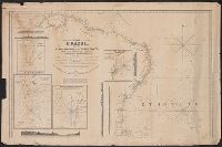
- Beinecke Rare Book and Manuscript Library > A New General Chart of the Coast of Brazil ... order of the Portuguese Government ... by Joseph Foss Dessiou ... London by W. Faden ... 1818.
- Published / Created:
- [1831?]
- Call Number:
- 811 1831
- Container / Volume:
- BRBL_00552
- Image Count:
- 1
- Resource Type:
- Maps, Atlases & Globes
- Found in:
- Beinecke Rare Book and Manuscript Library > Michigan.
- Published / Created:
- [1831?]
- Call Number:
- 761 1831
- Container / Volume:
- BRBL_00447
- Image Count:
- 1
- Resource Type:
- Maps, Atlases & Globes
- Found in:
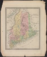
- Beinecke Rare Book and Manuscript Library > Maine.
- Creator:
- Gray, Thomas R
Turner, Nat, 1800?-1831
- Published / Created:
- 1831
- Call Number:
- JWJ Zan T856 831Cb
- Image Count:
- 28
- Found in:
- Beinecke Rare Book and Manuscript Library > The confessions of Nat Turner, the leader of the late insurrection in Southampton, Virginia as fully and voluntarily made to Thomas R. Gray, in the prison where he was confined, and acknowledged by him to be such when read before the court of Southampton
- Published / Created:
- 1831
- Call Number:
- Za M497 Zz831L
- Image Count:
- 130
- Found in:
- Beinecke Rare Book and Manuscript Library > The London carcanet : containing select passages from the most distinguished writers / from the 2d London ed.
- Creator:
- Dwight, E. W. (Edwin Welles), 1789-1841.
- Published / Created:
- [ca. 1832?]
- Call Number:
- Mjv38 D96 1800
- Image Count:
- 1
- Resource Type:
- Books, Journals & Pamphlets
- Found in:
- Beinecke Rare Book and Manuscript Library > Memoir of Henry Obookiah : a native of the Sandwich Islands, who died at Cornwall, Connecticut, February 17, 1818, aged 26.
- Creator:
- Phelps, Humphrey
- Published / Created:
- 1832
- Call Number:
- 771 1833
- Container / Volume:
- BRBL_00478
- Image Count:
- 1
- Resource Type:
- Maps, Atlases & Globes
- Found in:
- Beinecke Rare Book and Manuscript Library > Map of the state of New York with the latest improvements / by H. Phelps.
- Published / Created:
- 1832
- Call Number:
- 75 1832P
- Container / Volume:
- BRBL_00398
- Image Count:
- 1
- Resource Type:
- Maps, Atlases & Globes
- Found in:
- Beinecke Rare Book and Manuscript Library > Map of the United States.
- Published / Created:
- [1833?]
- Call Number:
- 796 1833B
- Container / Volume:
- BRBL_00524
- Image Count:
- 1
- Resource Type:
- Maps, Atlases & Globes
- Found in:
- Beinecke Rare Book and Manuscript Library > Map of the southern part [of] Texas / E.S. Mesier, lith.
- Published / Created:
- 1833
- Call Number:
- 771 N49 1833
- Container / Volume:
- BRBL_00485
- Image Count:
- 1
- Resource Type:
- Maps, Atlases & Globes
- Found in:
- Beinecke Rare Book and Manuscript Library > City of New York, by David H. Burr.
- Published / Created:
- [1833]-
- Call Number:
- Shirley S328
- Image Count:
- 1
- Found in:
- Beinecke Rare Book and Manuscript Library > Parley's magazine.
- Published / Created:
- 1834
- Call Number:
- 806gmb C43 1834
- Container / Volume:
- BRBL_00549
- Image Count:
- 1
- Resource Type:
- Maps, Atlases & Globes
- Found in:
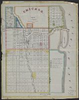
- Beinecke Rare Book and Manuscript Library > Chicago. Drwn by J.S.Wright, according to survey.
- Published / Created:
- [1834]
- Call Number:
- 771 J222 1834
- Container / Volume:
- BRBL_00483
- Image Count:
- 1
- Resource Type:
- Maps, Atlases & Globes
- Found in:
- Beinecke Rare Book and Manuscript Library > Map of property at Jamaica belonging to Abrm. H. Van Wyck.
- Published / Created:
- 1835
- Call Number:
- 97 L62 1685
- Container / Volume:
- BRBL_00678
- Image Count:
- 1
- Resource Type:
- Maps, Atlases & Globes
- Found in:
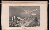
- Beinecke Rare Book and Manuscript Library > View of Lima. "The City of Kings." before its destruction by the great earthquake of 1746.
- Published / Created:
- 1835
- Call Number:
- 804 C599 1835
- Container / Volume:
- BRBL_00544
- Image Count:
- 1
- Resource Type:
- Maps, Atlases & Globes
- Found in:
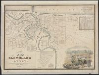
- Beinecke Rare Book and Manuscript Library > Map of Cleveland and its Environs. Surveyed and Published gy Ahaz Merchant.
- Creator:
- Burr, David H., 1803-1875
- Published / Created:
- 1835
- Call Number:
- 796 1835C
- Container / Volume:
- BRBL_00524
- Image Count:
- 1
- Resource Type:
- Maps, Atlases & Globes
- Found in:
- Beinecke Rare Book and Manuscript Library > Texas / by David H. Burr ; engraved by S. Stiles & Co.
- Published / Created:
- 1836
- Call Number:
- 811 Al53 1836
- Container / Volume:
- BRBL_00553
- Image Count:
- 1
- Resource Type:
- Maps, Atlases & Globes
- Found in:
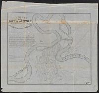
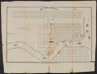
- Beinecke Rare Book and Manuscript Library > A plan of the city of Allegan, situated on the Kalamazoo River in the County of Allegan and Territory of Michigan.
- Published / Created:
- 1836
- Call Number:
- 811 1836
- Container / Volume:
- BRBL_00552
- Image Count:
- 1
- Resource Type:
- Maps, Atlases & Globes
- Found in:
- Beinecke Rare Book and Manuscript Library > An improved edition of a map of the survryed part of the Territory of Michigan. by John Farmer
- Published / Created:
- 1836
- Call Number:
- 806 1836A
- Container / Volume:
- BRBL_00547
- Image Count:
- 1
- Resource Type:
- Maps, Atlases & Globes
- Found in:
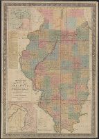
- Beinecke Rare Book and Manuscript Library > New SectionalMap of the State of Illinois. Compiled from the United States Surveys. Also exhibiting the Internal Improvements distances between Town Villages Post Offices, the outlines of Prairies. Woodlands Marshe. By J.M. Peck and John Messinger
- Published / Created:
- 1836
- Call Number:
- 771 H154 1836
- Container / Volume:
- BRBL_00482A
- Image Count:
- 1
- Resource Type:
- Maps, Atlases & Globes
- Found in:
- Beinecke Rare Book and Manuscript Library > Map of 134 Building at Hallett's Cove, L.I. For sale by order of the Ct. of Chancery at the store of F.H. Blackwell & Co. at Hallet's Cove on the 7th of May, 1836.
- Published / Created:
- 1837
- Call Number:
- 811 1837
- Container / Volume:
- BRBL_00552
- Image Count:
- 1
- Resource Type:
- Maps, Atlases & Globes
- Found in:
- Beinecke Rare Book and Manuscript Library > The Surveyed Part of Michigan by John Farmer.
- Published / Created:
- March 22, 1837.
- Call Number:
- 796 V541 1837
- Container / Volume:
- BRBL_00528
- Image Count:
- 1
- Resource Type:
- Maps, Atlases & Globes
- Found in:
- Beinecke Rare Book and Manuscript Library > The city of Velasco.
- Published / Created:
- [1838]
- Call Number:
- 2009 904
- Image Count:
- 52
- Resource Type:
- Books, Journals & Pamphlets
- Found in:
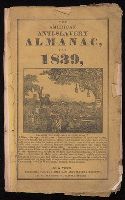
- Beinecke Rare Book and Manuscript Library > The American anti-slavery almanac, for 1839 : ... Calculated for New York; adapted to the northern and middle states. [Motto: one line].
- Published / Created:
- 1840
- Call Number:
- 919cea 1840
- Container / Volume:
- BRBL_00673
- Image Count:
- 1
- Resource Type:
- Maps, Atlases & Globes
- Found in:
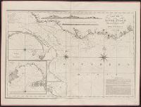
- Beinecke Rare Book and Manuscript Library > New Chart of the River Plate: Improved by Edmund and George W. Blunt, and Published by Edmund M. Blunt ... New York.
- Published / Created:
- 1840
- Call Number:
- 911cea 1840A
- Container / Volume:
- BRBL_00670
- Image Count:
- 1
- Resource Type:
- Maps, Atlases & Globes
- Found in:
- Beinecke Rare Book and Manuscript Library > The Coast of Brazil from Cape Frio to the River Plate ...
- Published / Created:
- [1840?]
- Call Number:
- 785 C17 1840
- Container / Volume:
- BRBL_00513
- Image Count:
- 1
- Resource Type:
- Maps, Atlases & Globes
- Found in:
- Beinecke Rare Book and Manuscript Library > [Cape Hatteras.]
- Creator:
- Tanner, Henry Schenck, 1786-1858
- Published / Created:
- 1840
- Call Number:
- 75gm 1840C
- Container / Volume:
- BRBL_00410
- Image Count:
- 1
- Resource Type:
- Maps, Atlases & Globes
- Found in:
- Beinecke Rare Book and Manuscript Library > Map of the canals & rail roads of the United States / reduced from the large map of the U.S. by H.S. Tanner ; engraved by J. Knight.
- Creator:
- Tanner, Henry Schenck, 1786-1858
- Published / Created:
- 1840
- Call Number:
- 75gm 1840B
- Container / Volume:
- BRBL_00410
- Image Count:
- 1
- Resource Type:
- Maps, Atlases & Globes
- Found in:
- Beinecke Rare Book and Manuscript Library > Map of the canals & rail roads of the United States / reduced from the large map of the U.S. by H.S. Tanner ; engraved by J. Knight.
- Published / Created:
- 1840
- Call Number:
- 30 1840A
- Container / Volume:
- BRBL_00031
- Image Count:
- 1
- Resource Type:
- Maps, Atlases & Globes
- Found in:
- Beinecke Rare Book and Manuscript Library > Europe with part of Asia and Africa.
- Creator:
- Hooker, William, 1782-1856
- Published / Created:
- 1841
- Call Number:
- BrSides 2019 100
- Image Count:
- 1
- Resource Type:
- Maps, Atlases & Globes
- Found in:
- Beinecke Rare Book and Manuscript Library > Long Island Sound : reduced from the large chart as surveyed by E. Blunt / engraved for Blunt's American coast pilot by W. Hooker.
- Creator:
- Hunt, Richard S
- Published / Created:
- [1841?]
- Call Number:
- 796 1841A
- Container / Volume:
- BRBL_00524
- Image Count:
- 1
- Resource Type:
- Maps, Atlases & Globes
- Found in:
- Beinecke Rare Book and Manuscript Library > Map of Texas / compiled from surveys on record in the general land office of the republic, to the year 1841, by Richard S. Hunt and Jesse F. Randel ; engraved by Stiles, Sherman & Smith.
- Published / Created:
- 1841
- Call Number:
- 76 1614A
- Container / Volume:
- BRBL_00443
- Image Count:
- 1
- Resource Type:
- Maps, Atlases & Globes
- Found in:
- Beinecke Rare Book and Manuscript Library > The original Carte Figurative, of wich the above is an accurate Fac-Simile was found ... 1841 in ... the Royal Archives at the Hague ... 1614, and is referred to in the Memorial as showing the extent of the discoveries [in New England] made by ... Hendric
- Published / Created:
- 1841
- Call Number:
- 213cea 1819
- Image Count:
- 1
- Resource Type:
- Maps, Atlases & Globes
- Found in:
- Beinecke Rare Book and Manuscript Library > A chart of the Cape Verd[e] Islands by Lieuts. Vidal & Mudge, of H.M. Ship Leven ... in 1819,20 & 21. Engraved & Printed by W. Hooker.
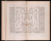
- Creator:
- Catherwood, Frederick
Stephens, John Lloyd, 1805-1852
- Published / Created:
- 1841
- Call Number:
- 2003 261
- Image Count:
- 2
- Found in:
- Beinecke Rare Book and Manuscript Library > Incidents of travel in Central America, Chiapas, and Yucatan / by John L. Stephens.
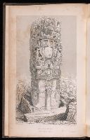
- Creator:
- Catherwood, Frederick
Stephens, John Lloyd, 1805-1852
- Published / Created:
- 1841
- Call Number:
- 2003 261
- Image Count:
- 5
- Found in:
- Beinecke Rare Book and Manuscript Library > Incidents of travel in Central America, Chiapas, and Yucatan / by John L. Stephens.
- Creator:
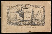
- Töpffer, Rodolphe, 1799-1846
- Published / Created:
- September 14, 1842.
- Call Number:
- 1974 +S12
- Image Count:
- 41
- Found in:
- Beinecke Rare Book and Manuscript Library > The adventures of Mr. Obadiah Oldbuck : wherein are duly set forth the crosses, chagrins, calamities, checks, chills, changes, and circumgirations by which his courtship was attended : showing also the issue of his suit and his espousal to his ladye-love.
- Published / Created:
- 1843
- Call Number:
- 811 1843
- Container / Volume:
- BRBL_00552
- Image Count:
- 1
- Resource Type:
- Maps, Atlases & Globes
- Found in:
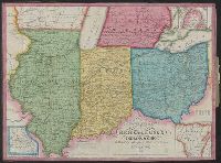
- Beinecke Rare Book and Manuscript Library > Traveller's map of Michigan, Indiana & Ohio.
- Published / Created:
- 1843
- Call Number:
- 771 B796 1843
- Container / Volume:
- BRBL_00481
- Image Count:
- 1
- Resource Type:
- Maps, Atlases & Globes
- Found in:
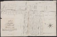
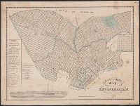
- Beinecke Rare Book and Manuscript Library > Hayward's map of the City of Brooklyn, ... 1843.
- Published / Created:
- [1843?]
- Call Number:
- 755 1843A
- Container / Volume:
- BRBL_00441
- Image Count:
- 1
- Resource Type:
- Maps, Atlases & Globes
- Found in:
- Beinecke Rare Book and Manuscript Library > Map exhibiting the country between Lakes Michigan and Erie and the contested boundary lines.
- Creator:
- Norman, Benjamin Moore, 1809-1860
- Published / Created:
- 1843
- Call Number:
- 2003 176
- Image Count:
- 4
- Found in:
- Beinecke Rare Book and Manuscript Library > Rambles in Yucatan, or, Notes of travel through the peninsula : including a visit to the remarkable ruins of Chi-Chen, Kabak, Zayi, and Uxmal / by B.M. Norman.
- Published / Created:
- 1844
- Call Number:
- 755 1844
- Container / Volume:
- BRBL_00441
- Image Count:
- 1
- Resource Type:
- Maps, Atlases & Globes
- Found in:
- Beinecke Rare Book and Manuscript Library > Guide through Ohio, Michigan, Indiana, Illinois, Missouri, Wisconsin & Iowa by J. Calvin Smith ...
- Published / Created:
- [1844?]
- Call Number:
- 75 1844
- Container / Volume:
- BRBL_00399
- Image Count:
- 1
- Resource Type:
- Maps, Atlases & Globes
- Found in:
- Beinecke Rare Book and Manuscript Library > Map of the United States and Texas. Engraved by C. Copley, New York.
- Creator:
- Anderson, Alexander, 1775-1870
George F. Cooledge & Brother
Redfield & Savage
- Published / Created:
- [between 1844 and 1871?]
- Call Number:
- Shirley 2398
- Image Count:
- 10
- Resource Type:
- Books, Journals & Pamphlets
- Found in:
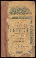
- Beinecke Rare Book and Manuscript Library > The blue pictorial primer : designed for the use of schools and families : embellished with more than one hundred fine engravings.
- Creator:
- Töpffer, Rodolphe, 1799-1846
- Published / Created:
- [1844]
- Call Number:
- 2010 247
- Image Count:
- 80
- Found in:
- Beinecke Rare Book and Manuscript Library > The adventures of Mr. Obadiah Oldbuck : wherein are duly set forth the crosses, chagrins, calamities, checks, chills, changes, and circumgirations, by which his courtship was attended : showing also the issue of his suit and his espousal to his lady-love.
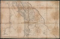
- Creator:
- Wilkes, Charles, 1798-1877
- Published / Created:
- [1845]
- Call Number:
- 80 1841B
- Container / Volume:
- BRBL_00533
- Image Count:
- 1
- Resource Type:
- Maps, Atlases & Globes
- Found in:
- Beinecke Rare Book and Manuscript Library > Map of the Oregon Territory / by the U.S. Ex. Ex., Charles Wilkes, 1841.
- Creator:
- Atwood, John M., approximately 1818-
- Published / Created:
- 1848, ©1845.
- Call Number:
- 75 1848P
- Container / Volume:
- BRBL_00399
- Image Count:
- 1
- Resource Type:
- Maps, Atlases & Globes
- Found in:
- Beinecke Rare Book and Manuscript Library > Phelps's national map of the United States [cartographic material] : a travellers' guide : embracing the principal rail roads, canals, steam boat & stage routes, throughout the Union / drawn & engraved by J.M. Atwood.
- Published / Created:
- 1845
- Call Number:
- 61 1845
- Container / Volume:
- BRBL_00331
- Image Count:
- 1
- Resource Type:
- Maps, Atlases & Globes
- Found in:
- Beinecke Rare Book and Manuscript Library > Egypt, the Peninsula of Mt. Sinai and Arabia Petrea with the Southern part of Palestine ... Dr. R.S. Fisher, Delt. J.M. Atwood, Sc. N.Y.
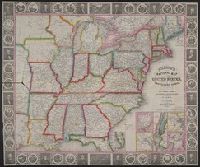
- Creator:
- Burr, David H., 1803-1875
- Published / Created:
- 1846
- Call Number:
- 796 1846A
- Container / Volume:
- BRBL_00524
- Image Count:
- 1
- Resource Type:
- Maps, Atlases & Globes
- Found in:
- Beinecke Rare Book and Manuscript Library > The state of Texas, 1836-1845 / by David H. Burr ; engraved by S. Stiles & Co.
- Published / Created:
- 1846
- Call Number:
- 75 1846C
- Container / Volume:
- BRBL_00399
- Image Count:
- 1
- Resource Type:
- Maps, Atlases & Globes
- Found in:
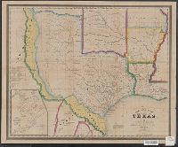
- Beinecke Rare Book and Manuscript Library > Map of the United States and Mexico Including Oregon, Texas and the Californias. By John Haven.
- Published / Created:
- 1847
- Call Number:
- 88 M57 1847A
- Container / Volume:
- BRBL_00647
- Image Count:
- 1
- Resource Type:
- Maps, Atlases & Globes
- Found in:
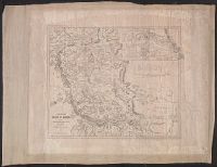
- Beinecke Rare Book and Manuscript Library > Map of the Valley of Mexico and the surrounding mountains.
- Published / Created:
- [1847?]
- Call Number:
- 88hc 1847E
- Container / Volume:
- BRBL_00649
- Image Count:
- 1
- Resource Type:
- Maps, Atlases & Globes
- Found in:
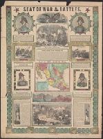
- Beinecke Rare Book and Manuscript Library > Seat of war & battles.
- Published / Created:
- [1847?]
- Call Number:
- 88hc 1847B
- Container / Volume:
- BRBL_00649
- Image Count:
- 2
- Resource Type:
- Maps, Atlases & Globes
- Found in:
- Beinecke Rare Book and Manuscript Library > Seat of war & battles.
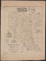
- Creator:
- Bruff, Joseph Goldsborough, 1804-1889
- Published / Created:
- 1847
- Call Number:
- 88hc 1847A
- Container / Volume:
- BRBL_00649
- Image Count:
- 1
- Resource Type:
- Maps, Atlases & Globes
- Found in:
- Beinecke Rare Book and Manuscript Library > A correct map of the seat of war in Mexico : being a copy of Gen.l Arista's map taken at Resaca de la Palma with additions and corrections, embellished with diagrams of the battles of 8th & 9th May, and capture of Monterey, with a memorandum of forces eng
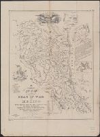