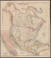
Includes tables of distances for overland routes and sea routes., Inset: Map of the gold region California. Scale [ca. 1:4,752,000]., Prime meridian: Washington, D.C., and Relief shown by hachures.
Includes tables of distances for overland routes and sea routes., Inset map: Map of the gold region, California., Prime meridian: Washington, D.C., and Relief shown by hachures.
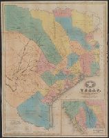
"Entered according to Act of Congress in the year 1839, by J.H. Colton, in the Clerks Office of the District Court of the Southern District of New York.", Library's copy annotated in pencil and orange ink., Prime meridians: Greenwich and Washington., and Relief shown by hachures.
Publisher:
J.H. Colton,
Subject (Geographic):
Texas--Administrative and political divisions--Maps and Texas--Maps
Subject (Name):
J.H. Colton & Co, Randel, Jesse F, and Stiles, Sherman & Smith
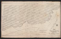
Miniature sailing chart showing the route of Colombus from Oct. 11, 1492 up to approx. the 1st. of Dec. 1492. Also shown are the Great Bahama Bank, the Old Bahama Channel, part of Cuba, Jamaica, Saint Domingo, ect. and Plan by D.G. Johnson. Lettered by D.R. Harrison.
Miniature sailing chart showing the route of Colombus from Oct. 11, 1492 up to approx. the 1st. of Dec. 1492. Also shown are the Great Bahama Bank, the Old Bahama Channel, part of Cuba, Jamaica, Saint Domingo, ect. and Plan by D.G. Johnson. Lettered by D.R. Harrison.
"Hydrography by the party under the command of Wm. P. McArthur, Assistant U.S.C.S., Lieut. U.S.N. ....", Also covers most of Mare Island., At top of map: Genl. M.G. Vallejo's possessions., Shows drainage, block and lot numbers, etc., and Soundings in feet.
Publisher:
Lith. of Wm. Endicott & Co.,
Subject (Geographic):
Vallejo (Calif.)--Maps
Subject (Name):
McArthur, William Pope, 1814-1850 and W. Endicott & Co
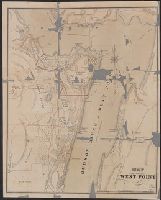
Imperfect: mutilated, with some loss of text., Map Collection acquisition record: 2757., and Removed from: Guide to West Point, New York, 1867. Egk64 W52 867