Search
You Searched For
Search Results
- Creator:
- H.H. Lloyd & Co
- Published / Created:
- 1867, c1866.
- Call Number:
- 771 N49 1867A
- Container / Volume:
- BRBL_00487
- Image Count:
- 2
- Resource Type:
- Maps, Atlases & Globes
- Found in:
- Beinecke Rare Book and Manuscript Library > 40 miles around New York ; H.H. Lloyd's new map of the great metropolis, : including the cities of New York, Brooklyn, Jersey City, Hoboken, &c.
- Creator:
- Smith, J. Calvin (John Calvin)
- Published / Created:
- 1870, c1856.
- Call Number:
- 75 1870S
- Container / Volume:
- BRBL_00404
- Image Count:
- 1
- Resource Type:
- Maps, Atlases & Globes
- Found in:
- Beinecke Rare Book and Manuscript Library > A new map for travelers through the United States of America showing the railroads, canals & stage roads with the distances / by J. Calvin Smith ; eng. on steel by Sherman & Smith, N.Y.
- Creator:
- Cozans, Philip J., publisher
- Published / Created:
- [between 1861 and 1867?]
- Call Number:
- Shirley 2103
- Image Count:
- 7
- Found in:
- Beinecke Rare Book and Manuscript Library > Adventures of Little Red Riding Hood
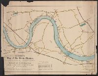
- Published / Created:
- [1869]
- Call Number:
- 321 1869
- Container / Volume:
- BRBL_00054A
- Image Count:
- 1
- Resource Type:
- Maps, Atlases & Globes
- Found in:
- Beinecke Rare Book and Manuscript Library > An illustrated Map of the River Thames, as compiled from the Ordnance Survey, showing the exact course of the Harvard and Oxford Boat Race. Putney to Mortlake, 4 miles, 2 Furlongs.
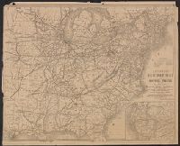
- Creator:
- Thomas, G. F
- Published / Created:
- [1864]
- Call Number:
- 75gme 1864
- Container / Volume:
- BRBL_00412
- Image Count:
- 2
- Resource Type:
- Maps, Atlases & Globes
- Found in:
- Beinecke Rare Book and Manuscript Library > Appletons' railway map of the United States and the Canadas : representing railways in actual operation, and those in course of construction, also map of the territories, showing the Pacific Railroad, gold regions, &c. / carefully compiled by G. F. Thomas
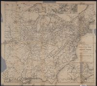
- Creator:
- Thomas, G. F
- Published / Created:
- [1876]
- Call Number:
- 754gme 1876
- Container / Volume:
- BRBL_00420
- Image Count:
- 2
- Resource Type:
- Maps, Atlases & Globes
- Found in:
- Beinecke Rare Book and Manuscript Library > Appletons' railway map of the United States and the Canadas : representing railways in actual operation, and those in course of construction, also map of the territories, showing the Pacific Railroad, gold regions, &c. / carefully compiled by G. F. Thomas
- Published / Created:
- 1876
- Call Number:
- 766 1876A
- Container / Volume:
- BRBL_00466
- Image Count:
- 1
- Resource Type:
- Maps, Atlases & Globes
- Found in:
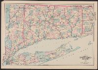
- Beinecke Rare Book and Manuscript Library > Asher & Adams' Connecticut
- Creator:
- Jocelyn, Albert H
- Published / Created:
- [1860?]
- Call Number:
- 35311hc Se21 1860
- Container / Volume:
- BRBL_00112
- Image Count:
- 1
- Resource Type:
- Maps, Atlases & Globes
- Found in:
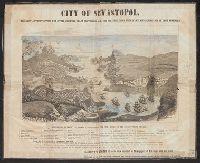
- Beinecke Rare Book and Manuscript Library > City of Sevastopol : the only authentic view yet given, showing exact positions of all the fortifications with name and description of each appended / A.H. Jocelyn, eng.
- Creator:
- G.W. & C.B. Colton & Co
- Published / Created:
- 1878, c1855.
- Call Number:
- 766 1878
- Container / Volume:
- BRBL_00466
- Image Count:
- 1
- Resource Type:
- Maps, Atlases & Globes
- Found in:
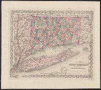
- Beinecke Rare Book and Manuscript Library > Colton's Connecticut : with portions of New York & Rhode Island.
- Creator:
- G.W. & C.B. Colton & Co
- Published / Created:
- 1868
- Call Number:
- 766 1868
- Container / Volume:
- BRBL_00466
- Image Count:
- 1
- Resource Type:
- Maps, Atlases & Globes
- Found in:
- Beinecke Rare Book and Manuscript Library > Colton's Connecticut : with portions of New York & Rhode Island.