Skip to search
Skip to main content
Skip to first result
Search
You Searched For
Extent of Digitization
Completely digitized
Format
cartographic
Genre
Atlases
Publication Place
Norimbergae
New Search
Search Results
Creator:
Published / Created:
1720?
Call Number:
1975 Folio 31
Collection Title:
[Atlas factice of 42 maps, produced by the Homann Erben firm]
Image Count:
1
Publisher:
Johann Baptist Homann
Subject (Geographic):
Netherlands --Maps --Early works to 1800 and New York (State) --Maps
Subject (Topic):
Atlases, German --Early works to 1800
Collection Created:
[Nuremberg,
Found in:
Beinecke Rare Book and Manuscript Library > Belgii pars septentrionalis communi nomine vulgo Hollandia nuncupata continens statum potentissimae Batavorum Reipublicea sev provincias VII foederatas / exhibente Io. Baptista Homanno
Creator:
Published / Created:
1715?
Call Number:
1973 Folio 30
Collection Title:
[Atlas factice of 32 maps and 1 distance table, produced by the Homann Erben firm]
Image Count:
2
Publisher:
[Johann Baptist Homann]
Subject (Geographic):
Saxony (Germany) --Maps --Early works to 1800
Subject (Topic):
Atlases, German --Early works to 1800
Collection Created:
[Nuremberg : s.n., 1701-1760]
Found in:
Beinecke Rare Book and Manuscript Library > Circulus Saxoniae inferioris in omnes suos status et principatus / [cartographic material] / accurate divisus ex conatibus Io. Bapt. Homanni
Creator:
Published / Created:
a. 1760
Call Number:
1973 Folio 30
Collection Title:
[Atlas factice of 32 maps and 1 distance table, produced by the Homann Erben firm]
Image Count:
2
Alternative Title:
Comitatus Schoenburgensis
Publisher:
Edentibus Homannianis Heredibus
Subject (Geographic):
Zwickau (Germany : Landkreis) --Maps --Early works to 1800
Subject (Topic):
Atlases, German --Early works to 1800
Collection Created:
[Nuremberg : s.n.,
Found in:
Beinecke Rare Book and Manuscript Library > Comitatvs Schoenburgensis [cartographic material] : in quo celsissimorum comitum de Schoenburg regiones ad circulum Saxoniae superiorem Imperii Romano-Germanici pertinentes et in Marchionatu Misniae sitae, subfeuda porro Bohemico-Imperialia, nempe Dynasti
Creator:
Published / Created:
1730
Call Number:
1975 Folio 31
Collection Title:
[Atlas factice of 42 maps, produced by the Homann Erben firm]
Image Count:
1
Alternative Title:
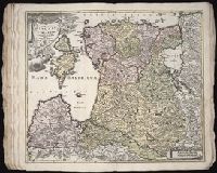
Ducatuum Livoniae et Curlandiae cum vicinis insulis
Publisher:
Johann Baptist Homann
Subject (Geographic):
Estonia --Maps --Early works to 1800 and Latvia --Maps --Early works to 1800
Subject (Topic):
Atlases, German --Early works to 1800
Collection Created:
[Nuremberg,
Found in:
Beinecke Rare Book and Manuscript Library > Ducatvvm Livoniae et Cvrlandiae cum vicinis insulis [cartographic material] : nova exhibitio geographica / editore Ioh. Baptista Homanno
Creator:
Published / Created:
1720?
Call Number:
1975 Folio 31
Collection Title:
[Atlas factice of 42 maps, produced by the Homann Erben firm]
Image Count:
1
Publisher:
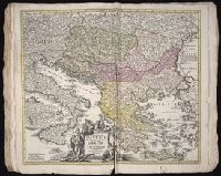
Johann Baptist Homann
Subject (Geographic):
Balkan Peninsula --Maps --Early works to 1800
Subject (Topic):
Atlases, German --Early works to 1800
Collection Created:
[Nuremberg,
Found in:
Beinecke Rare Book and Manuscript Library > Fluviorum in Europa principis Danubii [cartographic material] : cum adiacentibus regnis nec non totius Graeciae et archipelagi novissima tabula / authore Joh. Baptista Homanno
Creator:
Published / Created:
1720?
Call Number:
1973 Folio 30
Collection Title:
[Atlas factice of 32 maps and 1 distance table, produced by the Homann Erben firm]
Image Count:
2
Publisher:
Johann Baptist Homann
Subject (Geographic):
Balkan Peninsula --Maps --Early works to 1800
Subject (Topic):
Atlases, German --Early works to 1800
Collection Created:
[Nuremberg : s.n., 1701-1760]
Found in:
Beinecke Rare Book and Manuscript Library > Fluviorum in Europa principis Danubii [cartographic material] : cum adiacentibus regnis nec non totius Graeciae et archipelagi novissima tabula / authore Joh. Baptista Homanno
Creator:
Published / Created:
a. 1751
Call Number:
1973 Folio 30
Collection Title:
[Atlas factice of 32 maps and 1 distance table, produced by the Homann Erben firm]
Image Count:
2
Alternative Title:
Helvetia tredecim statibus liberis, quos cantones vocant composita and Suisse, divisee en ses treze cantons, ses alliez et ses sujets
Publisher:
Luci publicae tradita ab Homannianis Heredibus
Subject (Geographic):
Switzerland --Maps --Early works to 1800
Subject (Topic):
Atlases, German --Early works to 1800
Collection Created:
[Nuremberg : s.n., 1701-1760]
Found in:
Beinecke Rare Book and Manuscript Library > Helvetia tredecim statibvs liberis, qvos cantones vocant composita [cartographic material] : una cum foederatis & subjectis provinciis, ex probatissimis subsidiis / geographice delineata per Dm. Tobiam Mayerum, Professorem Matth., Goettingensem
Creator:
Published / Created:
ca. 1724
Call Number:
1975 Folio 31
Collection Title:
[Atlas factice of 42 maps, produced by the Homann Erben firm]
Image Count:
1
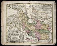
Publisher:
Johann Baptist Homann
Subject (Geographic):
Iran --Maps --Early works to 1800 and Middle east --Maps --Early works to 1800
Subject (Topic):
Atlases, German --Early works to 1800
Collection Created:
[Nuremberg,
Found in:
Beinecke Rare Book and Manuscript Library > Imperii Persici in omnes suas provincias (tam veteribus quam modernis earundem nominibus signatas) [cartographic material] : exacte divisi nova tabula geographica / quam ex praecipuis Olearii, Tavernieri, Relandi aliorumque recentium authoreum scriptis co
Creator:
Published / Created:
[1746?]
Call Number:
1973 Folio 30
Collection Title:
[Atlas factice of 32 maps and 1 distance table, produced by the Homann Erben firm]
Image Count:
2
Alternative Title:
Allemagne distinguee en ses cercles & subdivisee en ses etats, contenant son etendue presente rectifiee & methodiquement enluminee suivant les elements de geographie de Mr. Schatz and Imperii Romano Germanici in suos status et circulos divisi tabula generalis
Publisher:
[Homann Erben?]
Subject (Geographic):
Austria --Maps --Early works to 1800, Czechoslovakia --Maps --Early works to 1800, Germany --Maps --Early works to 1800, Hungary --Maps --Early works to 1800, and Poland --Maps --Early works to 1800
Subject (Topic):
Atlases, German --Early works to 1800
Collection Created:
[Nuremberg : s.n.,
Found in:
Beinecke Rare Book and Manuscript Library > Imperii Romano Germanici in svos statvs et circvlos divisi tabvla generalis in ufus iuventutis erundiendae accommodata / [cartographic material] / a Ioh Bapt Homanno, S.C.M. Geographo, Reg. Boruss. Societ. Scient. Sodali
Creator:
Published / Created:
ca. 1741
Call Number:
1975 Folio 31
Collection Title:
[Atlas factice of 42 maps, produced by the Homann Erben firm]
Image Count:
2
Alternative Title:
Allemagne distinguee en ses cercles & subdivisee en ses etats, contenant son etendue presente rectifiee & methodiquement enluminee suivant les elements de geographie de Mr. Schatz a 1741 avec privilege imperial and Imperii Romano Germanici in suos status et circulos divisi tabula generalis
Publisher:
Homann Erben?
Subject (Geographic):
Austria --Maps --Early works to 1800, Czechoslovakia --Maps --Early works to 1800, Germany --Maps --Early works to 1800, Hungary --Maps --Early works to 1800, and Poland --Maps --Early works to 1800
Subject (Topic):
Atlases, German --Early works to 1800
Collection Created:
[Nuremberg,
Found in:
Beinecke Rare Book and Manuscript Library > Imperii Romano Germanici in svos statvs et circvlos divisi tabvla generalis in ufus iuventutis erundiendae accommodata / a Ioh Bapt Homanno, S.C.M. Geographo, Reg. Boruss. Societ. Scient. Sodali
Branch:v1.61.6 ,Deployed:2024-06-12T09:55:36-04:00