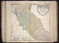
[Atlas factice of 50 maps, primarily by Johann Baptist Homann and/or issued by the Homann Erben
Image Count:
1
Alternative Title:
Etats de l’Eglise & du Grand Duche de Toscane, Etats de l’Eglise & du Grand Dvche de Toscane, and Status Ecclesiastici nec non Magni Ducatus Toscanae nova tabula geographica
Publisher:
Curantibus Homannianis Heredibus
Subject (Geographic):
Papal States --Maps --Early works to 1800 and Tuscany (Italy) --Maps --Early works to 1800
Homann Erben (Firm) Homann, Johann Baptist, 1663-1724
Published / Created:
[1741?]
Call Number:
1983 Folio 23
Collection Title:
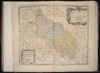
[Atlas factice of 50 maps, primarily by Johann Baptist Homann and/or issued by the Homann Erben
Image Count:
1
Alternative Title:
Allemagne distingue?e en ses cercles & subdivise?e en ses e?tats, contenant son e?tendue pre?sente rectifie?e & me?thodiquement enlumine?e suivant les e?le?ments de ge?ographie de Mr. Schatz a 1741 avec privilege imperial and Imperii Romano Germanici in suos status et circulos divisi tabula generalis
Publisher:
[Homann Erben?]
Subject (Geographic):
Austria --Maps --Early works to 1800, Czechoslovakia --Maps --Early works to 1800, Germany --Maps --Early works to 1800, Hungary --Maps --Early works to 1800, and Poland --Maps --Early works to 1800
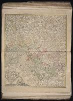
[Atlas factice of 50 maps, primarily by Johann Baptist Homann and/or issued by the Homann Erben
Image Count:
1
Alternative Title:
Ducatus Silesiae tabula geographica generalis, Duche de Silesie suivant l’e´tat present drese par Tobie Maier, et publie par les Heritiers de Homann a Nuremberg, and Dvche de Silesie suivant l’etat present drese par Tobie Maier, et publie par les Heritiers de Homann a Nuremberg
Publisher:
Impensis Homannianorum Heredum
Subject (Geographic):
Silesia (Czech Republic) --Maps --Early works to 1800
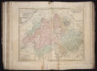
[Atlas factice of 50 maps, primarily by Johann Baptist Homann and/or issued by the Homann Erben
Image Count:
1
Publisher:
Edita sumtibus Homannianorum Heredum
Subject (Geographic):
Bremen (Germany : Duchy) --Maps --Early works to 1800, Hannover (Germany : Province) --Maps --Early works to 1800, Lower Saxony (Germany) --Maps --Early works to 1800, and Westphalia (Germany) --Maps --Early works to 1800