Skip to search
Skip to main content
Skip to first result
Search
You Searched For
"Interiors"
Resource Type
Maps, Atlases & Globes
Publication Place
Ottawa :
New Search
Search Results
Creator:
Published / Created:
[1922]
Call Number:
735gb 1922
Container / Volume:
BRBL_00382
Image Count:
1
Resource Type:
Maps, Atlases & Globes
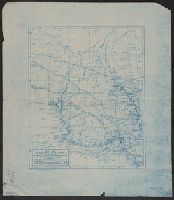
Description:
Shows resources labelled, water power (dev. & undev.), railroads & place names.
Publisher:
Natural Resources Intelligence Branch,
Subject (Name):
Canada. Dept. of the Interior
Subject (Topic):
Natural resources--Ontario--Algoma (District)--Maps
Found in:
Beinecke Rare Book and Manuscript Library > Map of Algoma district, Ontario, showing natural resources / prepared in the Natural Resources Intelligence Branch, Department of the Interior.
Creator:
Published / Created:
1921
Call Number:
733gb 1921
Container / Volume:
BRBL_00379
Image Count:
1
Resource Type:
Maps, Atlases & Globes
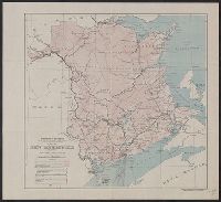
Description:
Shows timber lands, farm lands, mines and mineral prospects, mills, creameries, and locations where types of fish are caught.
Publisher:
Dept. of Interior ,
Subject (Geographic):
New Brunswick--Economic conditions--Maps
Subject (Topic):
Natural resources--New Brunswick--Maps
Found in:
Beinecke Rare Book and Manuscript Library > Map of New Brunswick, indicating natural resources / prepared in the Natural Resources Intelligence Branch.
Creator:
Interior
Published / Created:
1886
Call Number:
74FBC 1886
Container / Volume:
BRBL_00394
Image Count:
1
Resource Type:
Maps, Atlases & Globes
Alternative Title:
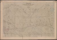
Map showing mounted police stations and patrols throughout the North-West Territories
Description:
"Photo. lith. by the Burland Litho. Co., Montreal." and Published by authority of the Right Hon. Sir John A. MacDonald, G.C.B.
Publisher:
Canada. Dept. of the Interior ,
Subject (Geographic):
Assiniboia, District of (Sask. and Alta.)--Maps and Prairie Provinces--Historical geography--Maps
Subject (Name):
Johnston, J and North West Mounted Police (Canada)--Maps
Subject (Topic):
Mounted police--Prairie Provinces--Maps
Found in:
Beinecke Rare Book and Manuscript Library > Map shewing mounted police stations & patrols throughout the North-West Territories : during the year 1886 / compiled, drawn and published under the superintendence of J. Johnston, chief draftsman, Department of the Interior.
Creator:
Interior
Published / Created:
[1914?]
Call Number:
737 C88 1914
Container / Volume:
BRBL_00385
Image Count:
5
Resource Type:
Maps, Atlases & Globes
Alternative Title:
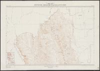
Crowsnest Forest and Waterton Lakes Park
Description:
"From photographic surveys by M.P. Bridgland, D.L.S., assisted by A.E. Hyatt.", Includes index to sheets., and Shows relief by contours & spot heights, place names, index to adjoining sheets.
Publisher:
Dept of the Interior ,
Subject (Geographic):
Crowsnest Pass (Alta. and B.C.)--Maps, Rocky Mountains Forest Reserve (Alta.)--Maps, and Waterton Lakes National Park (Alta.)--Maps
Subject (Name):
Canada. Office of the Surveyor General
Found in:
Beinecke Rare Book and Manuscript Library > Map of Crowsnest Forest and Waterton Lakes Park, Rocky Mountains Forest Reserve / drawn and printed at the Surveyor General's Office.
Creator:
Interior
Published / Created:
1913
Call Number:
739gme 1913
Container / Volume:
BRBL_00393
Image Count:
4
Resource Type:
Maps, Atlases & Globes
Description:
All maps west of the 5th & 7th meridians., Donald sheet -- Sicamous sheet -- Kamloops to Lytton sheet -- Port Moody to Yale sheet., and Relief shown by hachures and spot heights.
Publisher:
The Dept.,
Subject (Geographic):
British Columbia--Maps
Subject (Topic):
Land tenure--British Columbia--Maps
Found in:
Beinecke Rare Book and Manuscript Library > British Columbia railway belt : map showing disposition of Lands / prepared under the direction of F.C.C. Lynch, Superintendent of Railway Lands.
Creator:
Interior
Published / Created:
1935
Call Number:
738 1935
Container / Volume:
BRBL_00387
Image Count:
1
Resource Type:
Maps, Atlases & Globes
Publisher:
Office of the Surveyor General,
Subject (Geographic):
Saskatchewan--Maps
Found in:
Beinecke Rare Book and Manuscript Library > Saskatchewan south / prepared and printed at the Office of the Surveyor General, Ottawa, 1935.
Published / Created:
1904
Call Number:
739 1904
Container / Volume:
BRBL_00388
Image Count:
1
Resource Type:
Maps, Atlases & Globes
Description:
Cities; towns; railways; Indian reserves and villages; national parks; survey districts, sections and lots; forest reserves; electric railway.
Publisher:
Department of the Interior ;
Subject (Geographic):
British Columbia--Maps
Found in:
Beinecke Rare Book and Manuscript Library > British Columbia railway belt / [by] James White, F.R.G.S., Geographer: Department of the Interior; Honourable Clifford Sifton, Minister; James S. Smart, Deputy Minister.
Published / Created:
1925
Call Number:
736 P26 1925
Container / Volume:
BRBL_00382
Image Count:
1
Resource Type:
Maps, Atlases & Globes
Publisher:
Dept. of the Interior ,
Subject (Geographic):
Manitoba--Maps and Saskatchewan--Maps
Found in:
Beinecke Rare Book and Manuscript Library > Map of The Pas mineral area and adjacent territory to the north, Manitoba and Saskatchewan / ǂc compiled, drawn and printed by the Topographical Survey of Canada.
Creator:
Published / Created:
1925
Call Number:
737 L14 1925
Container / Volume:
BRBL_00385
Image Count:
1
Resource Type:
Maps, Atlases & Globes
Description:
Shows lot lines, roads & trails, contours (V.I 100 ft.) and gasoline car line.
Publisher:
Canada.Dept of the Interior ,
Subject (Geographic):
Lake Louise (Alta.)--Maps
Found in:
Beinecke Rare Book and Manuscript Library > Plan of Lake Louise and vicinity [map] / drawn and printed by the Topographical Survey of Canada.
Published / Created:
1910
Call Number:
736gc 1910
Container / Volume:
BRBL_00383
Image Count:
1
Resource Type:
Maps, Atlases & Globes
Publisher:
Dept. of the Interior ,
Subject (Geographic):
Manitoba--Maps
Found in:
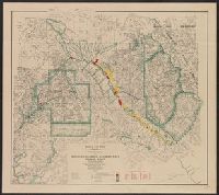
Beinecke Rare Book and Manuscript Library > Sketch map showing timber conditions along part of the proposed route of the Hudson Bay Railway.
Branch:v1.61.6 ,Deployed:2024-06-12T09:55:37-04:00