Skip to search
Skip to main content
Skip to first result
Search
You Searched For
Format
cartographic
Publication Place
Paris :
New Search
Search Results
Creator:
Published / Created:
1909
Call Number:
911 1909
Container / Volume:
BRBL_00669
Image Count:
2
Resource Type:
Maps, Atlases & Globes
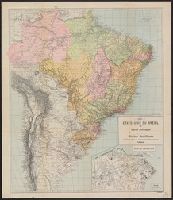
Description:
Descriptive text on verso., Includes inset map of Rio de Janeiro., and Relief shown by hachures.
Publisher:
Mission Brésilienne de Propagande et d'Expansion Économique,
Subject (Geographic):
Brazil--Administrative and political divisions--Maps and Brazil--Maps
Subject (Topic):
Central business districts--Brazil--Rio de Janeiro--Maps
Found in:
Beinecke Rare Book and Manuscript Library > États-Unis du Brésil : carte politique / organisée par la Mission Brésilienne de Propagande et d'Expansion Économique, Paris.
Creator:
Published / Created:
1908
Call Number:
911 1908A
Container / Volume:
BRBL_00667
Image Count:
2
Resource Type:
Maps, Atlases & Globes
Description:
Descriptive text on verso., Includes inset map of Rio de Janeiro., and Relief shown by hachures.
Publisher:
Mission Brésilienne de Propagande et d'Expansion Économique,
Subject (Geographic):
Brazil--Administrative and political divisions--Maps and Brazil--Maps
Subject (Topic):
Central business districts--Brazil--Rio de Janeiro--Maps
Found in:
Beinecke Rare Book and Manuscript Library > États-Unis du Brésil [cartographic material] : carte politique / organisée par la Mission Brésilienne de Propagande et d'Expansion Économique, Paris.
Published / Created:
1911
Call Number:
11hcf 1919D-32
Container / Volume:
BRBL_00010X
Image Count:
1
Resource Type:
Maps, Atlases & Globes
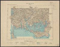
Alternative Title:
Vannes
Description:
"Carte de la France dressée par ordre du Ministre de l'Intérieur ... Mise à jour en Août 1911."
Publisher:
Ministre de l'Intérieur,
Subject (Geographic):
Vannes (France)--Maps
Found in:
Beinecke Rare Book and Manuscript Library > Feuille VI-18 : Vannes.
Published / Created:
[1947]
Call Number:
38 1947
Container / Volume:
BRBL_00155
Image Count:
1
Resource Type:
Maps, Atlases & Globes
Alternative Title:
Carte Blondel
Description:
Eighteen inset maps of French colonies.
Publisher:
Blondel la Rougery,
Subject (Geographic):
France--Administrative and political divisions--Maps and France--Maps
Found in:
Beinecke Rare Book and Manuscript Library > France Politique : Empire Franc̥ais Zone d'Occupation en Allemagne.
Published / Created:
1886
Call Number:
38 P21 1886
Container / Volume:
BRBL_00164
Image Count:
2
Resource Type:
Maps, Atlases & Globes
Description:
Made in two colors for guide-service and advertisement of Le Grand Hotel de Paris. and Verso: Western Railway of France, Compagnie Générale Transatlantique with insets: "Environs de Rouen" and "Watering places". Railroad map and prospectus of sights and wat
Publisher:
Hachette,
Subject (Geographic):
France--Maps and Paris (France)--Maps
Found in:
Beinecke Rare Book and Manuscript Library > Grand Hotel: Paris.
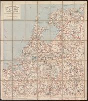
Creator:
Published / Created:
[1911?].
Call Number:
331gmb 1911
Container / Volume:
BRBL_00080
Image Count:
1
Resource Type:
Maps, Atlases & Globes
Alternative Title:
Cartes Tarides ; no. 33.
Description:
5 classes of roads with distances; railroads; customs offices.
Publisher:
Cartes Taride,
Subject (Geographic):
Netherlands--Road maps
Found in:
Beinecke Rare Book and Manuscript Library > Grande carte routière de la Hollande (Pays-Bas, Nederland) à l'usage des automobilistes, cyclistes, touristes, etc. [map].
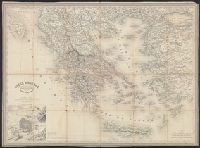
Creator:
Published / Created:
1856
Call Number:
48 1856
Container / Volume:
BRBL_00264
Image Count:
1
Resource Type:
Maps, Atlases & Globes
Publisher:
Paulin & Le Chevalier,
Subject (Geographic):
Greece--Maps
Subject (Name):
Dyonnet, Ch
Found in:
Beinecke Rare Book and Manuscript Library > Gréce moderne / dressée par A.H. Dufour, gravée par Ch. Dyonnet.
Published / Created:
1659
Call Number:
11 1659
Container / Volume:
BRBL_00003
Image Count:
1
Resource Type:
Maps, Atlases & Globes
Description:
Preliminary record.
Publisher:
Sanson,
Subject (Geographic):
World--Maps--Early works to 1800
Found in:
Beinecke Rare Book and Manuscript Library > Harmonie ou Correspondance du globe avecq la sphere par les points, lignes, cerches, &c ... par le S. Sanson d'Abbeville ... Jean Somer Pruthenus, Sculpsit.
Published / Created:
1782
Call Number:
13 1782
Container / Volume:
BRBL_00011
Image Count:
1
Resource Type:
Maps, Atlases & Globes
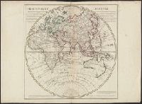
Description:
Showing routes of Captain Cook and other navigators.
Publisher:
Dezauche,
Subject (Geographic):
Eastern Hemisphere--Maps--Early works to 1800
Found in:
Beinecke Rare Book and Manuscript Library > Hemisphere Oriental ...
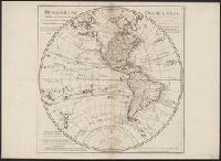
Creator:
Published / Created:
[1782]
Call Number:
70 1782
Container / Volume:
BRBL_00356
Image Count:
1
Resource Type:
Maps, Atlases & Globes
Description:
In lower right: Ph. Buache, P.G.d.R, d l'A.R.d.S. Gendre de l'auteur. Avec privilège du Roi., Library's copy stamped on backing: Yale University Library, Karpinski-Von Wieser Map Collection., and Relief shown pictorially.
Publisher:
Dezauche,
Subject (Geographic):
America--Discovery and exploration--Maps and Western Hemisphere--Maps
Subject (Name):
Buache, Philippe, 1700-1773, Cook, James--(1728-1779)--Travel--Maps, and Dezauche, J
Found in:
Beinecke Rare Book and Manuscript Library > Hemisphere occidental : dressé pour l'usage particulier du Roy, sur les observations astronomiques et géographiques, qui se trouvent rapportées dans l'histoire et dans les mémoires de l'Académie Rle. des Sciences / par Guillaume de l'Isle, premier ge
Branch:v1.61.6 ,Deployed:2024-06-12T09:55:31-04:00