Skip to search
Skip to main content
Skip to first result
Search
You Searched For
Date
1850 - 1899
Genre
Maps
Language
French
Publication Place
Paris :
Date Created
1850 to 1899
New Search
Search Results
Creator:
Published / Created:
1879
Call Number:
38 P21 1879
Container / Volume:
BRBL_00164
Image Count:
1
Resource Type:
Maps, Atlases & Globes
Description:
"Imprimé sur zinc.", Coordinates not present on map and are approximated., and Imperfect: mutilated on left side, with some loss of text.
Publisher:
Maison Logerot, J. Gaultier, Sr., Quai des Gds. Augustins, 55, Paris,
Subject (Geographic):
Paris (France)--Maps
Subject (Name):
Logerot, A. (Auguste)
Found in:
Beinecke Rare Book and Manuscript Library > Plan de Paris actuel.
Creator:
Published / Created:
[1877]
Call Number:
BrSides 2019 88
Image Count:
1
Resource Type:
Maps, Atlases & Globes
Alternative Title:
Atlas universal
Description:
"Atlas universal, Fayard Frères, editeurs, 78, Boul. St. Michel, Paris.", Coordinates not on map and are approximated., From Arthème Fayard's Atlas universal (1877)., and North oriented towards the right.
Publisher:
Imp. Michels et Fils,
Subject (Geographic):
Saint-Louis (Senegal)--Maps.
Subject (Name):
Fayard, Arthème, 1866-1936. Atlas universal.
Found in:
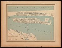
Beinecke Rare Book and Manuscript Library > Plan de Saint Louis (Sénégal) : d'après les cartes hydrographiques de la Marine / dressée par R. Hausermann.
Creator:
Published / Created:
[1877]
Call Number:
BrSides 2019 89
Image Count:
1
Resource Type:
Maps, Atlases & Globes
Alternative Title:
Atlas universal
Description:
"Atlas universal, Fayard Frères, editeurs, 78, Boul. St. Michel, Paris.", Coordinates not on map and are approximated., From Arthème Fayard's Atlas universal (1877)., and North oriented towards the right.
Publisher:
Imp. Michels et Fils,
Subject (Geographic):
Tunis (Tunisia)--Maps.
Subject (Name):
Fayard, Arthème, 1866-1936. Atlas universal.
Found in:
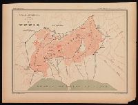
Beinecke Rare Book and Manuscript Library > Plan de Tunis / dressée par R. Hausermann.
Creator:
Published / Created:
[1856]
Call Number:
38 P21 1856
Container / Volume:
BRBL_00163
Image Count:
1
Resource Type:
Maps, Atlases & Globes
Alternative Title:
Guide dans Paris and Plan panorama de Paris
Description:
"Plan panorama de Paris, fortifié avec illustrtion."--In upper margin., Includes "Panorama pris de la Grille des Tuileries" and "Panorama pris du Pont Neuf" with drawings of major buildings embedded within the map., Includes street index., and Relief not shown.
Publisher:
[Par Lallemand] Rue des Poitevins No. 6,
Subject (Geographic):
Paris (France)--Maps
Found in:
Beinecke Rare Book and Manuscript Library > Plan garanti-complet, ou, Le guide dans Paris [cartographic material] / dressé par Lallemand, Géogrphe., grav. au Dépot de la Guerre, 1856.
Published / Created:
1873
Call Number:
38 M35 1873
Container / Volume:
BRBL_00158
Image Count:
1
Resource Type:
Maps, Atlases & Globes
Description:
In upper right margin: "Guide de L'Étranger dans Marseille par F. Peise".
Publisher:
Garnier Frères,
Subject (Geographic):
Marseille (France)--Maps
Found in:
Beinecke Rare Book and Manuscript Library > Plan général de Marseille : indiquant les travaux en voie d'exécution ainsi que les travaux projetés en 1873.
Published / Created:
[1859]
Call Number:
40hc 1859K
Container / Volume:
BRBL_00231
Image Count:
1
Resource Type:
Maps, Atlases & Globes
Description:
"Supplément au Journal le Monde Illustré". and Includes 4 bird's-eye views: [1.] Verone -- [2.] Mantoue -- [3.] Peschiera -- [4.] Legnago.
Publisher:
Imp. A Bourdilliat,
Subject (Geographic):
Italy, Northern--Maps
Found in:
Beinecke Rare Book and Manuscript Library > Plan topografique de la bataille de Solferino Quadrilatère stratègique. Détails des quatre places fortes. Supplément no. 8.
Creator:
Published / Created:
[1868?]
Call Number:
682H 1868
Container / Volume:
BRBL_00350
Image Count:
1
Resource Type:
Maps, Atlases & Globes
Description:
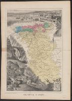
Inset of "Armes d'Alger" in lower right corner., Map of Algeria centered among pictorial representation of the town of Alger and a, and Shows civil and military regions noted by colors, agricultural colonies, regional boundaries, and elements of infrastructure.
Publisher:
Migeon,
Subject (Geographic):
Algeria--Maps
Found in:
Beinecke Rare Book and Manuscript Library > Province d'Alger / Dressé par A. Vuillemin.
Creator:
Published / Created:
[1868?]
Call Number:
682H 1868
Container / Volume:
BRBL_00350
Image Count:
1
Resource Type:
Maps, Atlases & Globes
Description:
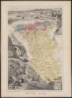
"Imp.e Migeon, Editeur, 11 rue du Moulin Vert, Paris.", Inset of "Armes d'Alger" in lower right corner., Map o, Scale in kilometres., and Shows civil and military regions noted by colors, agricultural colonies, regional boundaries, and elements of infrastructure.
Publisher:
Migeon,
Subject (Geographic):
Algeria--Maps
Found in:
Beinecke Rare Book and Manuscript Library > Province d'Alger / Dressé par A. Vuillemin.
Published / Created:
[1859]
Call Number:
40hc 1859F
Container / Volume:
BRBL_00231
Image Count:
1
Resource Type:
Maps, Atlases & Globes
Publisher:
Bulla Frères, and Goupil & Co. ;
Subject (Geographic):
Italy, Northern--Maps
Found in:
Beinecke Rare Book and Manuscript Library > Théâtre de la guerre en Italie : Vue prise a vol d'oiseau au dessus de Grenoble / Dessiné par Ph. Benoist ; Lith. par Eug. Cicéri.
Published / Created:
[1890?].
Call Number:
38gmb P21 1870
Container / Volume:
BRBL_00171
Image Count:
1
Resource Type:
Maps, Atlases & Globes
Description:
In upper right margin: "Pl. 6"., Legend indicates roadwork from 1850 to 1870, and after 1870., and Title supplied by cataloger.
Publisher:
L. Wuhrer,
Subject (Geographic):
Paris (France)--Maps
Found in:
Beinecke Rare Book and Manuscript Library > [Principales opérations de voirie exécutées à Paris].
Branch:v1.61.8 ,Deployed:2024-06-20T11:15:04-04:00