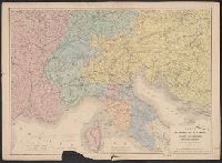
Shows steamboat lines; countries bordering the Mediterranean with colored politcal boundaries; roads, railroads, caravan routes, etc.; relief show by hachuring. Steel engraving.
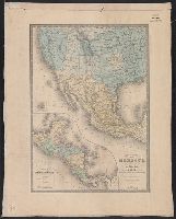
In lower right margin: No. 44., In upper right margin: Atlas universel en 67 feuilles no. 61., Insets: Carte de l'Amérique Centrale -- Iles Revillagigedo., and Relief shown by hachures.
Publisher:
Ch. Delagrave, Editeur de la Société de Géographie, and Institut Géographique de Paris :
Subject (Geographic):
Central America--Maps, Mexico--Maps, and United States--Maps
Subject (Name):
Brué, Adrien Hubert, 1786-1832, Delagrave, Ch. (Charles), 1842-1934, and Institut géographique de Paris
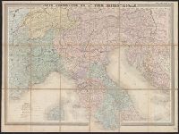
Cover wanting. Sheet measures 62 x 83 cm., Map of northern Italy showing fortified villas, forts, railroads in service, principal routes and rivers., and Relief shown by hachures.
Publisher:
Publié par E. Andriveau Goujon, Géographe-Editeur ...,