Skip to search
Skip to main content
Skip to first result
Search
You Searched For
Extent of Digitization
Unspecified
Access
Public
Repository
Beinecke Rare Book and Manuscript Library
Genre
Maps
Publication Place
Philadelphia
New Search
Search Results
Creator:
Published / Created:
1822
Call Number:
2003 Folio 81
Collection Title:
The New American Atlas ...
Container / Volume:
No. IV [4]
Image Count:
1
Description:
Already scanned for Mellon exhibit catalog, North America, S.W. sheet, and Printed by Wm. Duffee
Publisher:
H.S. Tanner
Subject (Geographic):
Mexico--Maps and North America--Maps
Collection Created:
Philadelphia : H.S. Tanner, 1822
Found in:
Beinecke Rare Book and Manuscript Library > A Map of North America, Constructed According to the Latest Information by H. S. Tanner
Published / Created:
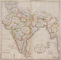
1818
Call Number:
1978 Folio 21
Collection Title:
Carey's General atlas, improved and enlarged; being a collection of maps of the world and quarters
Image Count:
1
Publisher:
M. Carey and Son
Collection Created:
Philadelphia: M. Carey and Son, 1818
Found in:
Beinecke Rare Book and Manuscript Library > An Accurate Map of Hindostan or India, from the best authorities
Published / Created:
1868
Call Number:
Zc19 K13k 868ka
Collection Title:
Letter of John D. Perry, President of the Union Pacific Railway, Eastern Division, together with
Image Count:
1
Description:
Preceding p. 1
Publisher:
Review Printing House
Subject (Geographic):
West (U.S.) --Maps
Subject (Name):
Union Pacific Railroad Company--Maps
Subject (Topic):
Railroads --West (U.S.) --Maps
Collection Created:
Philadelphia, Review Printing House, 1868
Found in:
Beinecke Rare Book and Manuscript Library > Map of the Routes of the Union Pacific Railroads with their Eastern Connections
Creator:
Published / Created:
1759
Call Number:
2003 Folio 85
Image Count:
1
Alternative Title:
Map of the improved part of the province of Pennsylvania
Description:
BEIN 2003 Folio 85: No. 20 of 45 maps bound together with binder's spine title: Atlas of America; ms. table of contents. Bookplate: Robinson. Bookplate of Paul Mellon., Hand colored., Relief shown pictorially., Scale [ca. 1:250,000]., and Shows county boundaries.
Publisher:
Sold by the author, Nicholas Scull
Subject (Geographic):
Pennsylvania -- Administrative and political divisions -- Maps -- Early works to 1800 and Pennsylvania -- Maps -- Early works to 1800
Found in:
Beinecke Rare Book and Manuscript Library > To the Honourable Thomas Penn and Richard Penn, Esqrs: true & absolute proprietaries & Governours of the Province of Pennsylvania & counties of New-Castle, Kent & Sussex on Delaware, this map of the improved part of the Province of Pennsylvania is humbly
Branch:v1.61.6 ,Deployed:2024-06-12T09:55:31-04:00