Skip to search
Skip to main content
Skip to first result
Search
You Searched For
Access
Public
Repository
Beinecke Rare Book and Manuscript Library
Format
cartographic
Genre
Maps
Publication Place
Philadelphia :
New Search
Search Results
Published / Created:
1795
Call Number:
327 1795B
Container / Volume:
BRBL_00072
Image Count:
1
Resource Type:
Maps, Atlases & Globes
Description:
From Carey's American Edition of Guthrie's Geography Improved.
Publisher:
Mathew Carey,
Subject (Geographic):
Ireland--Maps--Early works to 1800
Found in:
Beinecke Rare Book and Manuscript Library > A Map of Ireland according to the best authorities.
Published / Created:
1809
Call Number:
755 1809A
Container / Volume:
BRBL_00438
Image Count:
1
Resource Type:
Maps, Atlases & Globes
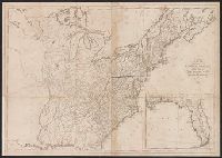
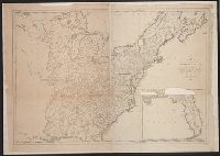
Description:
Inset: Florida.
Publisher:
Engraved for and sold by Matthew Carey,
Subject (Geographic):
Canada--Maps and East (U.S.)--Maps
Found in:
Beinecke Rare Book and Manuscript Library > A Map of the United States: compiled chiefly from the State Maps, and other Authentic Information, by Saml. Lewis.
Published / Created:
1795
Call Number:
11 1795
Container / Volume:
BRBL_00006
Image Count:
1
Resource Type:
Maps, Atlases & Globes
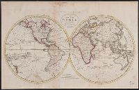
Description:
From Carey's American Edition of Guthrie's Geography Improved.
Publisher:
Mathew Carey,
Subject (Geographic):
World--Maps--Early works to 1800
Found in:
Beinecke Rare Book and Manuscript Library > A Map of the World from the best Authorities.
Published / Created:
1795
Call Number:
85 1795
Container / Volume:
BRBL_00637
Image Count:
1
Resource Type:
Maps, Atlases & Globes
Description:
From Carey's American Edition of Gutherie's Geography Improved., Negative on file., and W. Baker, sculp.
Publisher:
Mathew Carey,
Subject (Geographic):
West Indies--Maps--Early works to 1800
Found in:
Beinecke Rare Book and Manuscript Library > A chart of the West Indies, from the latest marine Journals and Surveys.
Creator:
Published / Created:
[1860]
Call Number:
18 1860A
Container / Volume:
BRBL_00013
Image Count:
1
Resource Type:
Maps, Atlases & Globes
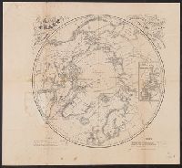
Description:
Includes note., Inset: Chart of Smith Strait and Kennedy Channel., and Shows northern hemisphere (34 diam.).
Publisher:
Bowen & C[o] Lith.,
Subject (Geographic):
Arctic regions--Discovery and exploration--Maps
Found in:
Beinecke Rare Book and Manuscript Library > A chart of the arctic regions : projected from Berghaus & Petermann, the charts of E.K. Kane, materials in the British Hydrographic office, etc. / eng. by W. Boell.
Creator:
Published / Created:
[1822 or 1823]
Call Number:
71 1822
Container / Volume:
BRBL_00369
Image Count:
4
Resource Type:
Maps, Atlases & Globes
Description:
In bottom left margin: Printed by Wm. Duffee., In top margin: American atlas., Includes text, ill., and insets of "Western part of the Aleutian Islands" and "Comparative altitudes of the mountains, towns &c. of North America.", and Possibly from 1923 ed. of Tanner's A new American atlas.
Publisher:
H.S. Tanner,
Subject (Geographic):
Central America--Maps and North America--Maps
Subject (Name):
Tanner, Henry Schenck, 1786-1858. New American atlas
Found in:
Beinecke Rare Book and Manuscript Library > A map of North America : constructed according to the latest information / engraved & published by H.S. Tanner, Philadelphia 1822.
Creator:
Published / Created:
1814
Call Number:
774fb W367 1814A
Container / Volume:
BRBL_00501
Image Count:
1
Resource Type:
Maps, Atlases & Globes
Alternative Title:
Map of Wayne and Pike counties, Pennsylvania
Description:
"Entered according to Act of Congress the 7th day of April, 1814, by Jason Torrey of the state of Pennsylvania." and Accompanied by text/index book: An index to the map of Wayne and Pike counties, Pennsylvania ... with explanatory remarks / by Jason Torrey. 7
Publisher:
Printed by Joseph Rakestraw,
Subject (Geographic):
Pennsylvania--Pike County. and Pennsylvania--Wayne County
Subject (Name):
Rakestraw, Joseph, 1780?-1860 and Tanner, Henry Schenck, 1786-1858
Subject (Topic):
Land grants, Land grants--Pennsylvania--Pike County--Maps., Land grants--Pennsylvania--Wayne County--Maps., Landowners, Landowners--Pennsylvania--Pike County--Maps., and Landowners--Pennsylvania--Wayne Co
Found in:
Beinecke Rare Book and Manuscript Library > A map of Wayne & Pike counties, Pennsylvania [cartographic material] : shewing the situations & forms of the warrantee tracts, with the numbers by which the respective tracts are distinguished in the maps & books in the Office of the Commissioners of plac
Published / Created:
1795
Call Number:
75 1795
Container / Volume:
BRBL_00396
Image Count:
1
Resource Type:
Maps, Atlases & Globes
Description:
5 copies. 2 copies damaged.
Publisher:
Matthew Carey,
Subject (Geographic):
United States--Maps--Early works to 1800
Found in:
Beinecke Rare Book and Manuscript Library > A map of the United States; Compiled chiefly from the State maps, and other authentic information, by Saml. Lewis. W. Harrison Jun. Sculp.
Branch:v1.61.6 ,Deployed:2024-06-12T09:55:19-04:00