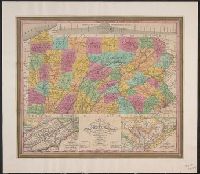
"Entered according to Act of Congress, April 15th, 1831 by S. Augustus Mitchell of the state of Pennsylvania.", Cover title in gold., Includes table of Pennsylvania population by counties, 1830, pasted inside front cover., and Insets: Profile of the Pennsylvania
Publisher:
Published by S. Augustus Mitchell,
Subject (Geographic):
Pennsylvania and Pennsylvania--Maps
Subject (Name):
Haines, D. and Mitchell, S. Augustus (Samuel Augustus), 1792-1868
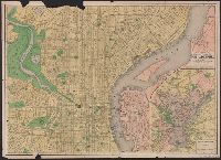
Imperfect: Mutilated, with some loss of text. Ms. annotations., Index to places of interest and streets on verso., and Inset: Philadelphia and vicinity. Scale [ca. 1:116 000].
Includes "View of Boston," inset of Halifax Harbor, and insets, with i, Inscribed to "His Majesty's Province of Nova Scotia ... ", Relief shown pictorially., and Shows the Maritime Provinces, Newfoundland, and the St. Laurence River Valley between 1755 and 1757.
Publisher:
Printed and sold by R. Aitken,
Subject (Geographic):
Canada--Maps--Early works to 1800, Halifax (N.S.)--Maps--Early works to 1800, Maritime Provinces--Maps--Early works to 1800, Nova Scotia--Maps--Early works to 1800, and Québec (Québec)--Maps--Early works to 1800
Subject (Name):
Aitken, Robert, 1735-1802
Subject (Topic):
Harbors--Nova Scotia--Louisbourg--Maps--Early works to 1800
Map of the improved part of the province of Pennsylvania
Description:
2nd state of 2 known states. Distinguishing features of 2nd state: "Four [sic] long lines of text have been added at right of the Narrows of the Susquehannah at Nelson's Ferry. A road now leads east from Carlisle direct to Pine Ford" (Wheat and Brun 89).
Publisher:
sold by the author Nicholas Scull,
Subject (Geographic):
Pennsylvania--Administrative and political divisions--Maps--Early works to 1800 and Pennsylvania--Maps--Early works to 1800
Subject (Name):
Davis, John, fl. 1756-1759, Penn, Richard, 1706-1771. dedication, Penn, Thomas, 1702-1775. dedication, and Turner, James, d. 1759. engraver
Also covers Washington, D.C., and parts of New Jersey, North Carolina, Kentucky and Pennsylvania., Includes list of "Altitudes of Mountains"., Inset map: Railroad ma, and Shows state and county boundaries, names of cities and towns, rivers, roads, and railroads.
Publisher:
Jacob Weiss lith.,
Subject (Geographic):
Delaware--Maps, Maryland--Maps, and Virginia--Maps