1. Railroad map of Michigan / prepared for the Commissioner of Railroads by O.W. Gray & Son. Creator: O.W. Gray & Son Published / Created: 1876 Call Number: 811 1876 Container / Volume: BRBL_00552 Image Count: 1 Resource Type: Maps, Atlases & Globes Description: Appears in Michigan Railroad Commission Subject (Geographic): Michigan--Maps Subject (Name): Michigan Railroad Commission Subject (Topic): Railroads--Michigan--Maps Found in: Beinecke Rare Book and Manuscript Library > Railroad map of Michigan / prepared for the Commissioner of Railroads by O.W. Gray & Son.
2. Neueste Karte von Michigan : nach den bessten Quellen bearbeitet. Published / Created: 1853 Call Number: 811 1853 Container / Volume: BRBL_00552 Image Count: 1 Resource Type: Maps, Atlases & Globes Description: Inset map "Westl. Theil von Michigan." Subject (Geographic): Michigan--Maps Found in: Beinecke Rare Book and Manuscript Library > Neueste Karte von Michigan : nach den bessten Quellen bearbeitet.
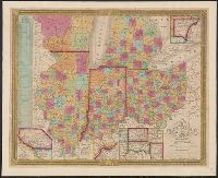
3. Map of the States of Ohio, Indiana, and Illinois with the settled part of Michigan. Published / Created: 1835 Call Number: 755 1835B Container / Volume: BRBL_00440 Image Count: 1 Resource Type: Maps, Atlases & Globes Found in: Beinecke Rare Book and Manuscript Library > Map of the States of Ohio, Indiana, and Illinois with the settled part of Michigan.
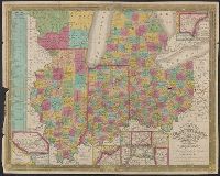
4. Map of the States of Ohio, Indiana, and Illinois with the settled part of Michigan. Published / Created: 1835 Call Number: 755 1835B Container / Volume: BRBL_00440 Image Count: 1 Resource Type: Maps, Atlases & Globes Found in: Beinecke Rare Book and Manuscript Library > Map of the States of Ohio, Indiana, and Illinois with the settled part of Michigan.