
You Searched For
1 - 7 of 7
Search Results
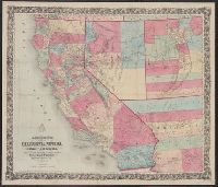
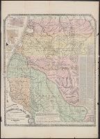
- Creator:
- A.L. Bancroft & Company
- Published / Created:
- 1876
- Call Number:
- 844 1876D
- Container / Volume:
- BRBL_00603
- Image Count:
- 1
- Resource Type:
- Maps, Atlases & Globes
- Alternative Title:
- Map of California, Nevada, Utah and Arizona
- Description:
- "Entered according to act of Congress by A.L. Bancroft & Company in the office of the Librarian of Congress, Washington, D.C.", Prime meridian: Washington, D.C., Relief shown by hachures and spot heights., and Shows wagon roads, proposed and completed railroads, mining districts, Indian reservations, etc.
- Publisher:
- A.L. Bancroft & Compy.,
- Subject (Geographic):
- California--Maps and Southwest, New--Maps
- Found in:
- Beinecke Rare Book and Manuscript Library > Bancroft's map of California, Nevada, Utah and Arizona.

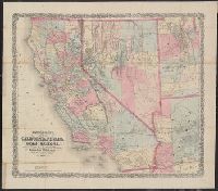
- Creator:
- H.H. Bancroft and Company
- Published / Created:
- 1862
- Call Number:
- 837gfc W27 1862
- Container / Volume:
- BRBL_00595
- Image Count:
- 1
- Resource Type:
- Maps, Atlases & Globes
- Alternative Title:
- Map of the Washoe silver region of Nevada Territory
- Description:
- Covers lands in Washoe, Storey, Lyon, and Ormsby counties. and Includes "Remarks," "Ideal plan of the Comstock lead [sic]," and "List of mining companies on the Comstock Ledge [sic], Gold Hill Grounds, and the supposed southern extension of the Comstock (beginning north)."
- Publisher:
- H.H. Bancroft & Company,
- Subject (Topic):
- Silver mines and mining--Nevada--Maps
- Found in:
- Beinecke Rare Book and Manuscript Library > Bancroft's map of the Washoe silver region of Nevada Territory.
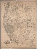
- Creator:
- G.W. & C.B. Colton & Co
- Published / Created:
- 1883
- Call Number:
- 80 1883A
- Container / Volume:
- BRBL_00536
- Image Count:
- 1
- Resource Type:
- Maps, Atlases & Globes
- Alternative Title:
- New township map of the Pacific states and territories
- Description:
- Also shows railroads., Prime meridians: Greenwich and Washington., and Relief shown by hachures.
- Publisher:
- G.W. & C.B. Colton & Co. ; and Payot, Upham & Co.,
- Subject (Geographic):
- Pacific States--Maps and West (U.S.)--Maps
- Found in:
- Beinecke Rare Book and Manuscript Library > Colton's new township map of the Pacific states and territories : California, Nevada, Oregon, Washington, Idaho, Montana, Wyoming, Utah and Arizona / G.W. & C.B. Colton & Co.
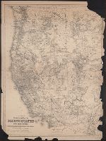
6.
- Creator:
- Cox, Gustavo
- Published / Created:
- 1865
- Call Number:
- 88192gfc 1865
- Container / Volume:
- BRBL_00653
- Image Count:
- 1
- Resource Type:
- Maps, Atlases & Globes
- Alternative Title:
- Mapa de las minas de cobre de la Isla de Carmen, Gulfo de California. and Plano de mineral distrito del Cacachilas.
- Description:
- "Sacado de varias notas de los ingenieros agrimensores del Gobierno de la Baja California Don Guillermo Denton y Ang. Cabrero.", Includes distance table., Insets: [Baja California Sur] -- Mapa de las minas de cobre de la Isla de Carmen, Gulfo de California -- Plano de mineral distrito del Cacachilas., Oriented with north toward right., Relief shown by hachures., and Spanish and English.
- Publisher:
- A. Gensoul,
- Subject (Geographic):
- Baja California Sur (Mexico)--Maps
- Subject (Name):
- Britton & Co and Gensoul, A. (Adrien)
- Subject (Topic):
- Mines and mineral resources--Mexico--Baja California Sur--Maps
- Found in:
- Beinecke Rare Book and Manuscript Library > Mapa de los distritos minerales de San Antonio, El Triunfo, Las Cacachilas y Isla de Carmen : Baja California, República de México / recopilado y delineado por Don Gustavo Cox, ingeniero de minas.
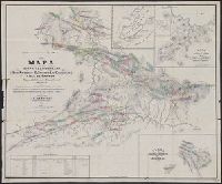
- Creator:
- Doolittle, A. J
- Published / Created:
- 1865
- Call Number:
- 844 H881 1865
- Container / Volume:
- BRBL_00604
- Image Count:
- 1
- Resource Type:
- Maps, Atlases & Globes
- Description:
- "By an act of the Board of Supervisors passed Feby. 9th, 1865.", Includes text, distance list, Calif. Surveyor General's certification, and statistics., Insets: Map of Eureka -- Map of Arcata., Relief shown by hachures., and Shows drainage, partial land ownership, townships, township and section lines, trails, etc.
- Publisher:
- A.J. Doolittle,
- Subject (Geographic):
- Humboldt County (Calif.)--Maps
- Found in:
- Beinecke Rare Book and Manuscript Library > The official township map of Humboldt Co., Cal. : carefully compiled from U.S. land and coast surveys, with personal observations / drawn and published by A.J. Doolittle.