Skip to search
Skip to main content
Skip to first result
Search
You Searched For
Extent of Digitization
Completely digitized
Access
Public
Repository
Beinecke Rare Book and Manuscript Library
Resource Type
Maps, Atlases & Globes
Publication Place
Southampton :
New Search
Search Results
Creator:
Published / Created:
1909
Call Number:
633 1909
Container / Volume:
BRBL_00336
Image Count:
1
Resource Type:
Maps, Atlases & Globes
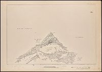
Alternative Title:
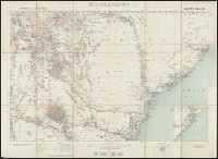
Africa 1:1 000 000., Geographical Section, General Staff ; no. 1539., GSGS (Series) ; 1539., and Kilimanjaro.
Description:
On back cover panel: Stanford's Leading Atlases ...
Publisher:
Printed at the Ordnance Survey Office,
Subject (Geographic):
Kilimanjaro, Mount (Tanzania)--Maps
Subject (Name):
Edward Stanford Ltd and Great Britain. Ordnance Survey
Found in:
Beinecke Rare Book and Manuscript Library > Africa 1:1 000 000. Kilimanjaro. Sheets 94 and 95 [cartographic material] / compiled in the Geographical Section, General Staff, 1905.
Creator:
Published / Created:
1901
Call Number:
6415 1902
Container / Volume:
BRBL_00338
Image Count:
1
Resource Type:
Maps, Atlases & Globes
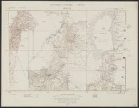
Alternative Title:
Blantyre., British Central Africa., G.S.G.S. ; no. 1764, and GSGS (Series) ; 1764.
Publisher:
Ordnance Survey,
Subject (Geographic):
Blantyre (Malawi : Region)--Maps
Found in:
Beinecke Rare Book and Manuscript Library > Africa 1:250 000. British Central Africa. Blantyre. Sheet III-P [cartographic material].
Creator:
Published / Created:
1913
Call Number:
634 P37 1913
Container / Volume:
BRBL_00336
Image Count:
2
Resource Type:
Maps, Atlases & Globes
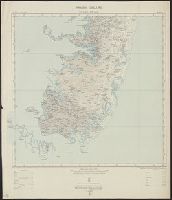
Alternative Title:
Great Britain. War Office. General Staff. Geographical Section. [G.S.G.S.], GSGS (Series) ; 2639., Pemba Island, Pemba Island. Chake Chake [cartographic material]., Pemba Island. Sheet 1 [cartographic material]., and Pemba Island. Sheet 2 [cartographic material].
Description:
Includes index to adjoining sheet. and Relief shown by contours.
Publisher:
Ordnance Survey Office,
Subject (Geographic):
Pemba Island (Tanzania)--Maps
Subject (Name):
Great Britain. War Office. General Staff. Geographical Section
Found in:
Beinecke Rare Book and Manuscript Library > Africa 1:63 360. Pemba Island [cartographic material] / drawn and printed at the Ordnance Survey Office, Southampton, 1913.
Published / Created:
1899
Call Number:
3229 1899
Container / Volume:
BRBL_00063
Image Count:
1
Resource Type:
Maps, Atlases & Globes
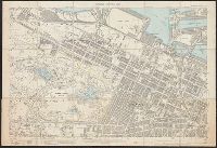
Description:
Street map. Shows Cleveland Ward, Claughton Ward and Grange Ward.
Publisher:
Ordnance Survey Office,
Subject (Geographic):
Cheshire (England)--Maps
Found in:
Beinecke Rare Book and Manuscript Library > Cheshire Sheet XIII.3 / Second Edition 1899.
Creator:
Published / Created:
1909
Call Number:
6554 1909
Container / Volume:
BRBL_00346
Image Count:
1
Resource Type:
Maps, Atlases & Globes
Alternative Title:
GSGS ; no. 2447 and GSGS ; no. 2447.
Description:
Ms. additions in red with note "ADDITIONS - 1928". and Shows boundaries and nearby provinces.
Publisher:
Ordnance Survey Office,
Subject (Geographic):
Gambia--Maps
Subject (Name):
Great Britain. War Office. General Staff. Geographical Section
Found in:
Beinecke Rare Book and Manuscript Library > Gambia.
Published / Created:
1910
Call Number:
3215ad 1910
Container / Volume:
BRBL_00056
Image Count:
6
Resource Type:
Maps, Atlases & Globes
Description:
1910, Ashley; 1930 Sparsholt; 1910, Farley, Chamberlayne; 1932, Hursly & Compton; 1910, Ampfield; 1931, Hursley & Otterbourne.
Publisher:
Ordnance Survey Office,
Subject (Geographic):
Hampshire (England)--Maps
Found in:
Beinecke Rare Book and Manuscript Library > Great Britain Ordnance Survey cadastral Plan.
Published / Created:
1920
Call Number:
32 L84 1920
Container / Volume:
BRBL_00051
Image Count:
1
Resource Type:
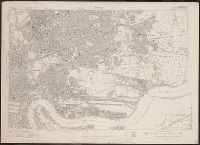
Maps, Atlases & Globes
Publisher:
Ordnance Survey Office,
Subject (Geographic):
London (England)--Maps
Found in:
Beinecke Rare Book and Manuscript Library > Great Britain Ordnance Survey edition of 1920.
Creator:
Published / Created:
1901
Call Number:
217 1899B
Image Count:
6
Resource Type:
Maps, Atlases & Globes
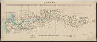
Description:
Includes index map. and Relief shown by contours and hachures.
Publisher:
The Office,
Subject (Geographic):
Bermuda Islands--Maps.
Subject (Name):
Savage, A. J
Found in:
Beinecke Rare Book and Manuscript Library > Islands of Bermuda [cartographic material] / surveyed and contoured in 1898-9 by Lieut. A.J. Savage, R.E. ; heliozincographed and published at the Ordnance Survey Office.
Creator:
Published / Created:
1913
Call Number:
327 K55 1913
Container / Volume:
BRBL_00073
Image Count:
1
Resource Type:
Maps, Atlases & Globes
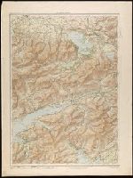
Alternative Title:
Ordnance Survey of Ireland (Third Edition), Killarney district
Description:
Relief shown by contours, altitude tints and spot heights.
Publisher:
Ordnance Survey Office,
Subject (Geographic):
Killarney Region (Kerry, Ireland)--Maps
Found in:
Beinecke Rare Book and Manuscript Library > Killarney district.
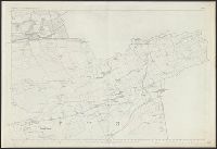
Published / Created:
1864
Call Number:
32631 1864
Container / Volume:
BRBL_00071
Image Count:
1
Resource Type:
Maps, Atlases & Globes
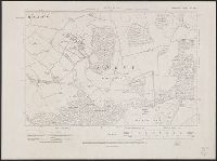
Description:
Preliminary record.
Publisher:
Ordnance Survey,
Subject (Geographic):
Lanarkshire (Scotland)--Maps--Early works to 1800
Found in:
Beinecke Rare Book and Manuscript Library > Lanarkshire. Sheet IX.
Branch:v1.61.6 ,Deployed:2024-06-12T09:55:31-04:00