Skip to search
Skip to main content
Skip to first result
Search
You Searched For
Format
cartographic
Publication Place
United States :
New Search
Search Results
Published / Created:
[185-]
Call Number:
754gme 1850C
Container / Volume:
BRBL_00419
Image Count:
1
Resource Type:
Maps, Atlases & Globes
Description:
Shows railroads and coal lands between Lakes Erie and Ontario and Long Island.
Publisher:
Bisbee, lith.,
Subject (Geographic):
United States--Maps
Found in:
Beinecke Rare Book and Manuscript Library > A map of the North Western Rail Way : passing thr'o [sic] the Lackawanna Coal Lands in Pennsylvania / by James Seymour.
Published / Created:
[191-?]
Call Number:
11hcf 1919A-23
Container / Volume:
BRBL_00010M
Image Count:
1
Resource Type:
Maps, Atlases & Globes
Alternative Title:
Czecho-Slovak claims
Description:
"Dr. Seymour" in upper left corner of sheet., Includes inset of Vienna and environs., Shows "Czecho-Slovak" and "Ruthenian" areas and Austria-Hungary border from 1914., and Title at head of sheet.
Publisher:
s.n.,
Subject (Geographic):
Austria--Maps, Europe, Eastern--Maps, and Hungary--Maps
Found in:
Beinecke Rare Book and Manuscript Library > Austria-Hungary : Czecho-Slovak claims.
Published / Created:
1920
Call Number:
848gme 1920
Container / Volume:
BRBL_00635
Image Count:
1
Resource Type:
Maps, Atlases & Globes
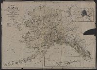
Description:
Imperfect: chipped with some loss of text., Inset map of the Aleutian Islands., and Inset map showing the relative size of Alaska and the United States.
Publisher:
s.n. ,
Subject (Geographic):
Alaska--Maps
Found in:
Beinecke Rare Book and Manuscript Library > Map of Alaska / compiled from maps of the U.S. Geological Survey, Alaska Road Commission, and from other data by Alaska Bureau Seattle Chamber of Commerce and Commerical Club 1920.
Creator:
Published / Created:
1911
Call Number:
846gbc J777 1911
Container / Volume:
BRBL_00623
Image Count:
1
Resource Type:
Maps, Atlases & Globes
Description:
Cadastral map showing land ownership. and Includes text.
Publisher:
Robert A. Welcke, Photo-lith.,
Subject (Geographic):
Josephine County (Or.)--Maps
Subject (Name):
Waldo Consolidated Gold Mining Company
Subject (Topic):
Gold mines and mining--Oregon--Josephine County--Maps and Real property--Oregon--Josephine County--Maps
Found in:
Beinecke Rare Book and Manuscript Library > Map of Waldo Consolidated Gold Mining Co. of Oregon : property in Waldo Mining District, Josephine County , Ore. / by A.H. Gunnell.
Published / Created:
1872
Call Number:
761 Y82 1872
Container / Volume:
BRBL_00449
Image Count:
2
Resource Type:
Maps, Atlases & Globes
Description:
"6" and "7" inside right-hand margin., Map removed from unknown atlas., On verso: Statistics of York County, business directories for Biddeford and Saco, Maine., and Stamped on verso: "Yale Univ. Lib. Map Coll. Sep 9 1964".
Publisher:
s.n. ,
Subject (Geographic):
York (Me.)--Maps
Found in:
Beinecke Rare Book and Manuscript Library > Map of York Co. Maine.
Published / Created:
[186-]
Call Number:
754gme 1867A
Container / Volume:
BRBL_00420
Image Count:
1
Resource Type:
Maps, Atlases & Globes
Description:
Shows rail lines between Lake Erie and Boston Harbor, hand colored. and Shows trunk lines in operation, constructing, and surveyed and ready for constructing, branches in operation, branch connections contemplated, and Erie railway and coal lines.
Publisher:
s.n.,
Subject (Geographic):
Northeastern States--Maps
Found in:
Beinecke Rare Book and Manuscript Library > Map of the Boston, Hartford & Erie Rail-Road.
Published / Created:
[185-].
Call Number:
754gme 1850B
Container / Volume:
BRBL_00419
Image Count:
1
Resource Type:
Maps, Atlases & Globes
Description:
Includes railroads surveyed, "do do finished or graded" and canals. and Shows railroads and coal fields from Brooklyn, NY to Wilkesbarre [sic], PA.
Publisher:
s.n ,
Subject (Geographic):
Northeastern States (U.S)--Maps
Subject (Topic):
Railroads--Northeastern States (U.S)--Maps
Found in:
Beinecke Rare Book and Manuscript Library > Map of the Central Rail Road of New Jersey : from the Bay of New York to Easton on the Delaware River, showing a line of rail thence to connect with the coal fields of Pennsylvania.
Creator:
Published / Created:
1849
Call Number:
11cfk 1850C-7
Container / Volume:
BRBL_00772
Image Count:
1
Resource Type:
Maps, Atlases & Globes
Alternative Title:
Maury's wind and current charts 1849
Publisher:
U.S. Navy,
Subject (Geographic):
Atlantic Ocean--Maps
Subject (Name):
United States. Hydrographic Office; United States. Depot of Charts and Instruments; United States Naval Observatory
Found in:
Beinecke Rare Book and Manuscript Library > Pilot chart of the coast of Brazil / by Lieut. M.F. Maury, U.S. Navy.
Branch:v1.61.6 ,Deployed:2024-06-12T09:55:36-04:00