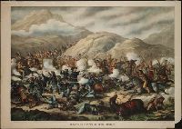
Print depicts the battle at the Little Big Horn river in Montana. Custer stands in the center of the action firing a pistol with each hand; Native Americans on horseback attacking dismounted U.S. soldiers
Description:
BEIN BrSides Zc43 889ba: On sheet 49 x 71 cm. and Title from caption below image. Title continues: June 25th. 1876. -- Gen. Custer, his two brothers, his nephew, and all his men (7th. Cavalry) were killed.
Publisher:
Published by Kurz & Allison, Art Publishers
Subject (Geographic):
Montana, United States, Montana., and United States.
Subject (Name):
Custer, George A. 1839-1876 (George Armstrong), and Custer, George A. 1839-1876. (George Armstrong),
Subject (Topic):
Little Bighorn, Battle of the, Mont., 1876 and History
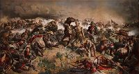
Print depicts Custer and dismounted U.S. soldiers attacked by mounted Native Americans; Custer, standing in center, pistol raised in his right hand, saber in his left
Description:
BEIN BrSides Zc43 881mu: Imperfect: Trimmed to image only; wanting caption title and attributions., Title from caption below image., and Signed in plate lower right corner: "Jno. Mulvaney 1881" and printed in plate lower left: copyrighted.
Publisher:
Chicago Litho. & Engraving Co.
Subject (Geographic):
United States, Montana., and United States.
Subject (Name):
Custer, George A. 1839-1876 (George Armstrong), and Custer, George A. 1839-1876. (George Armstrong),
Subject (Topic):
Little Bighorn, Battle of the, Mont., 1876 and Battles
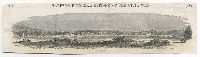
Woodcut illustration showing Fort Washita in mid-ground; two wagons in lower left; two riders and horses in lower right; with caption below image: Fort Wachita
Description:
BEIN BrSide4o Zc41 861fo: On sheet 6.5 x 24.5 cm that has been cut from the top of a larger sheet. and At head of sheet: 286. Harper's Pictorial history of the Civil War. 1861.
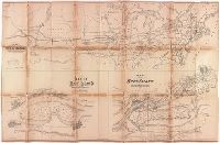
Map showing the relative position at Rock Island with the northwestern states and territories and its connections by rail roads and rivers
Description:
BEIN BrSides Elephant Folio 2017 14: Imperfect: brittle and chipped, with some loss of text., Relief shown by hachures., "Lith. by Ed Mendel, Chicago.", Coordinates not present on map and are approximated., and Includes two maps below: Map of Rock Island showing government property water power and Fort Armstrong; Map of Rock Island and vicinity with its coal fields.
Publisher:
publisher not identified
Subject (Geographic):
Illinois, Rock Island, United States, Rock Island., and United States.
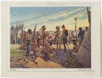
Print shows the meeting between Captain Nathan Heald and the Potawatomi the day before the massacre at Fort Dearborn; Heald, in uniform, standing beside interpreter (perhaps William Wells) in buckskin, talking with a Potawatomi leader (perhaps Black Partridge), also standing, while others, mostly men, sitting, listen; tipis to the sides of the image; prairie and sky in background
Alternative Title:
Fort Dearborn massacre
Description:
Title from caption below image. Signature of Glass and copyright date within the image. and The original image was a scene from his fifty-foot-long panoramic scene hung at the Century of Progress International Exposition (1933-1934) in Chicago, Ill.
Publisher:
Black Partridge Pagents, Inc.
Subject (Geographic):
United States
Subject (Name):
Heald, Nathan, 1775-1832, Wells, William, 1770-1812, and Black Partridge, active 1795-1816
Subject (Topic):
Fort Dearborn Massacre, Chicago, Ill., 1812, Potawatomi Indians, and History