Skip to search
Skip to main content
Skip to first result
Search
You Searched For
Publication Place
Washington, D. C. :
Search Results
Creator:
Published / Created:
c1995.
Call Number:
231 1995
Container / Volume:
BRBL_00020
Image Count:
2
Resource Type:
Maps, Atlases & Globes
Alternative Title:
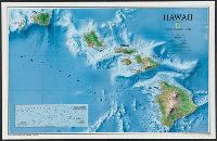
Rediscovering Hawaii
Description:
"Supplement to National Geographic, September 1995."
Publisher:
The Society,
Subject (Geographic):
Hawaii--Maps
Found in:
Beinecke Rare Book and Manuscript Library > Hawaii / produced by the Cartographic Division, National Geographic Society.
Published / Created:
1943
Call Number:
409gm 1943
Container / Volume:
BRBL_00240
Image Count:
1
Resource Type:
Maps, Atlases & Globes
Description:
Army Map Service.
Publisher:
Army Map Service, U.S. Army,
Subject (Geographic):
Italy--Maps
Subject (Topic):
Transportation
Found in:
Beinecke Rare Book and Manuscript Library > Sardinia: Special strategic map [cartographic material].
Creator:
Published / Created:
1936
Call Number:
823am 1936
Container / Volume:
BRBL_00569
Image Count:
1
Resource Type:
Maps, Atlases & Globes
Description:
"Supplement to the National Geographic Magazine, May, 1936."
Publisher:
National Geographic Society,
Subject (Geographic):
South Dakota--Maps
Subject (Name):
United States. Army. Air Corps. Stratosphere Flight, November 11, 1935
Found in:
Beinecke Rare Book and Manuscript Library > The first photograph ever made showing the division between the troposhere and the stratosphere and also the actual curvature of the earth : photographed from an elevation of 72,395 feet, the highest point ever reached by man.
Creator:
Published / Created:
[1918]
Call Number:
11hc 1917A
Container / Volume:
BRBL_00010D
Image Count:
1
Resource Type:
Maps, Atlases & Globes
Description:
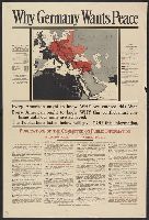
Includes "the Pan-German Plan as realized by War in Europe and in Asia, March 16, 1918"; shows colored map of Central Europe and its annexes in the Near East (Germany, Austria-Hungary, Bulgaria, Turkey); territory occupied or controlled by Central Pow...
Publisher:
Committee on Public Information,
Subject (Geographic):
Germany--Maps
Subject (Topic):
World War, 1914-1918--Maps
Found in:
Beinecke Rare Book and Manuscript Library > Why Germany wants peace : every American ought to know why we entered this War; every American ought to know why this conflict must continue until our aims are achieved; the publications listed below will give you this information.