Skip to search
Skip to main content
Skip to first result
Search
You Searched For
"United States--Maps"
Genre
Maps
Creator
United States. Army Map Service
Publication Place
Washington, D.C. :
New Search
Search Results
Creator:
United States . Army Map Service
Published / Created:
1944
Call Number:
28 SI315 1944
Container / Volume:
BRBL_00024
Image Count:
1
Resource Type:
Maps, Atlases & Globes
Alternative Title:
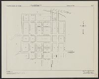
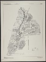
A.M.S. S901, Series (Standard map series designation system) ; S901., and Silay, Philippine Islands, Negros Occidental Province
Description:
"Copied from a map prepared by Manila Fire Insurance Association, 1939." and Most streets are named.
Publisher:
The Service,
Subject (Geographic):
Silay City (Negros Occidental, Philippines)--Maps
Found in:
Beinecke Rare Book and Manuscript Library > Philippine Islands city plans. Silay.
Creator:
United States . Army Map Service
Published / Created:
1944
Call Number:
28 Ap11 1944
Container / Volume:
BRBL_00023E
Image Count:
1
Resource Type:
Maps, Atlases & Globes
Alternative Title:
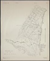
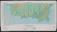
A.M.S. ; S901, Aparri, Philippine Islands, Cagayan Province, and Series (Standard map series designation system) ; S901.
Description:
"Copied from U.S.C. & G.S. chart 4260." and Important buildings are named; soundings are given.
Publisher:
The Service,
Subject (Geographic):
Aparri (Philippines)--Maps
Found in:
Beinecke Rare Book and Manuscript Library > Philippine Islands city plans. Aparri.
Creator:
United States . Army Map Service
Published / Created:
1944
Call Number:
28 D19 1944
Container / Volume:
BRBL_00023F
Image Count:
1
Resource Type:
Maps, Atlases & Globes
Alternative Title:
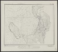
A.M.S. ; S901, Danao, Philippine Islands, Cebu Province, and Series (Standard map series designation system) ; S901.
Description:
"Copied from a blueprint prepared by the Philippine Scouts, 1907." and Some streets are named; "legend" indicates some buildings.
Publisher:
The Service,
Subject (Geographic):
Danao (Philippines)--Maps
Found in:
Beinecke Rare Book and Manuscript Library > Philippine Islands city plans. Danao.
Creator:
United States . Army Map Service
Published / Created:
1944
Call Number:
28 SA522 1944
Container / Volume:
BRBL_00024
Image Count:
1
Resource Type:
Maps, Atlases & Globes
Alternative Title:
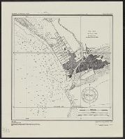
A.M.S. ; S901, San Fernando, Philippine Islands, La Union Province, and Series (Standard map series designation system) ; S901.
Description:
"Copied from U.S.C. & G.S. chart 4246." and Depth given in soundings.
Publisher:
The Service,
Subject (Geographic):
San Fernando (La Union, Philippines)--Maps
Found in:
Beinecke Rare Book and Manuscript Library > Philippine Islands city plans. San Fernando.
Creator:
United States . Army Map Service
Published / Created:
1944
Call Number:
28 T11 1944
Container / Volume:
BRBL_00024
Image Count:
1
Resource Type:
Maps, Atlases & Globes
Alternative Title:
A.M.S. ; S901, Series (Standard map series designation system) ; S901., and Taal and Lemery, Philippine Islands, Batangas Province
Description:
"Copied from U.S.C. & G.S. chart 4257 ... From survey in 1905." and "Soundings in feet at mean lower low water."
Publisher:
The Service,
Subject (Geographic):
Lemery (Batangas, Philippines)--Maps and Taal (Batangas, Philippines)--Maps
Found in:
Beinecke Rare Book and Manuscript Library > Philippine Islands city plans. Taal and Lemery.
Creator:
United States . Army Map Service
Published / Created:
1944
Call Number:
28 C147 1944
Container / Volume:
BRBL_00023F
Image Count:
1
Resource Type:
Maps, Atlases & Globes
Alternative Title:
A.M.S. ; S901, Camiling, Philippine Islands, Tarlac Province, and Series (Standard map series designation system) ; S901.
Description:
"Copied from a blueprint prepared by the 17th Infantry, 1900."
Publisher:
The Service,
Subject (Geographic):
Camiling (Tarlac, Philippines)--Maps
Found in:
Beinecke Rare Book and Manuscript Library > Philippine Islands city plans. Camiling.
Creator:
United States . Army Map Service
Published / Created:
1944
Call Number:
275 1944A
Container / Volume:
BRBL_00023B
Image Count:
1
Resource Type:
Maps, Atlases & Globes
Alternative Title:
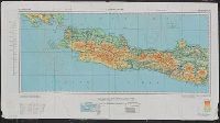
No. C-47. and South Borneo
Description:
Map on verso: No. C-48 West Java.
Publisher:
Army Map Service,
Subject (Geographic):
Borneo--Maps
Found in:
Beinecke Rare Book and Manuscript Library > AAF cloth chart. No. C-47. South Borneo.
Creator:
United States . Army Map Service
Published / Created:
1944
Call Number:
275 1944A
Container / Volume:
BRBL_00023B
Image Count:
1
Resource Type:
Maps, Atlases & Globes
Alternative Title:
No. C-48. and West Java
Description:
Map on verso: No. C-47 South Borneo.
Publisher:
Army Map Service,
Subject (Geographic):
Java (Indonesia)--Maps
Found in:
Beinecke Rare Book and Manuscript Library > AAF cloth chart. No. C-48. West Java.
Creator:
United States . Army Map Service
Published / Created:
1942
Call Number:
354 1942
Container / Volume:
BRBL_00112
Image Count:
1
Resource Type:
Maps, Atlases & Globes
Alternative Title:
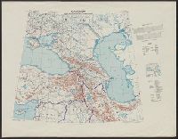
[G.S.G.S.] 4327 and GSGS (Series) ; 4327.
Description:
"Copied from a map produced by 512 (A. Fd. svy.) coy. R.E., January 1942 and collated by Mid-Asiatic bureau M.E.", In lower right corner of margin: Reprint November 1942., Relief shown by hachures and shading., and Two gauges of railroads, principal roads and tr
Publisher:
Army Map Service, U.S. Army,
Subject (Geographic):
Caucasus--Maps
Found in:
Beinecke Rare Book and Manuscript Library > Caucasia and neighbouring territories.
Creator:
United States . Army Map Service
Published / Created:
1942
Call Number:
352gme M94 1942A
Container / Volume:
BRBL_00111
Image Count:
1
Resource Type:
Maps, Atlases & Globes
Alternative Title:
Geographical Section, General Staff ; no. 4224 and GSGS (Series) ; no. 4224.
Description:
Five classes of roads and paths are also indicated., In lower left corner of margin: War Office 1941., and In lower right corner of margin: Reproduced from a Finnish map.
Publisher:
The Service,
Subject (Geographic):
Soviet Union--Maps
Subject (Topic):
Railroads--Soviet Union--Maps
Found in:
Beinecke Rare Book and Manuscript Library > Murmansk railway. Sheet 1.
Branch:v1.61.8 ,Deployed:2024-06-20T11:14:46-04:00