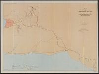
Search
You Searched For
Search Results
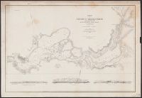
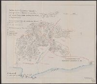
- Creator:
- Jones, Lewis A
- Published / Created:
- 1915
- Call Number:
- 794gcf B48 1914
- Container / Volume:
- BRBL_00521
- Image Count:
- 11
- Resource Type:
- Maps, Atlases & Globes
- Found in:
- Beinecke Rare Book and Manuscript Library > A report on the methods and cost of reclaiming the overflowed lands along the Big Black River, Mississippi / by Lewis A. Jones ; assisted by W.J. Schlick and C.E. Ramser.
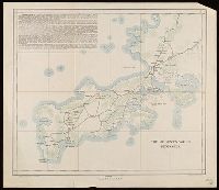
- Creator:
- United States. Army Map Service
- Published / Created:
- 1943
- Call Number:
- 5844 1943
- Container / Volume:
- BRBL_00315
- Image Count:
- 6
- Resource Type:
- Maps, Atlases & Globes
- Found in:
- Beinecke Rare Book and Manuscript Library > Malaya 1:253 440 : Pahang.
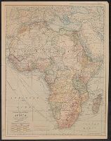
- Creator:
- Freyhold, Edward
- Published / Created:
- 1879
- Call Number:
- 80 1879
- Container / Volume:
- BRBL_00536
- Image Count:
- 5
- Resource Type:
- Maps, Atlases & Globes
- Found in:
- Beinecke Rare Book and Manuscript Library > Map of the territory of the United States, west of the Mississippi River / prepared by authority of the Hon. the Secretary of War, in the office of the Chief of Engineers under the direction of Brig. Gen. A.A. Humphreys, Chief of Engrs. Bvt. Major General
- Creator:
- Reyes, José Maria, 1803-1864
- Published / Created:
- c1893.
- Call Number:
- 93 1893
- Container / Volume:
- BRBL_00674
- Image Count:
- 1
- Resource Type:
- Maps, Atlases & Globes
- Found in:
- Beinecke Rare Book and Manuscript Library > Carta geográfica de la Republica Oriental del Uruguay [cartographic material] / reduccion dela del general ingeniero Don José M. Reyes. Aumentada y correjida en parte con antecedentes del archivo dela direccion gral de obras publicas por el vocal dela s
- Creator:
- Ringgold, Cadwalader, 1802-1867
- Published / Created:
- [1851?]
- Call Number:
- 844cea Sa52 1850D
- Container / Volume:
- BRBL_00614
- Image Count:
- 1
- Resource Type:
- Maps, Atlases & Globes
- Found in:
- Beinecke Rare Book and Manuscript Library > Chart of the Sacramento River from Suisun City to the American River : California / by Cadwalader Ringgold, Commander, U.S. Navy ; assisted by Edwin Cullberg, Lieut. of the Hydrotechnic Corps, Swedish Navy, and T.A. Emmet, civil engineer, 1850.
- Creator:
- Ringgold, Cadwalader, 1802-1867
- Published / Created:
- [1851?]
- Call Number:
- 844cea Sa52 1850A
- Container / Volume:
- BRBL_00614
- Image Count:
- 1
- Resource Type:
- Maps, Atlases & Globes
- Found in:
- Beinecke Rare Book and Manuscript Library > Chart of the Farallones and entrance to the bay of San Francisco : California / by Cadwalader Ringgold, Commander, U.S. Navy ; assisted by Simon F. Blunt, Lieut., U.S. Navy, 1850.
- Creator:
- Ringgold, Cadwalader, 1802-1867
- Published / Created:
- [1851?]
- Call Number:
- 844cea Sa52 1850B
- Container / Volume:
- BRBL_00614
- Image Count:
- 1
- Resource Type:
- Maps, Atlases & Globes
- Found in:
- Beinecke Rare Book and Manuscript Library > Chart of the bay of San Pablo, Straits of Carquines, and part of the bay of San Francisco : California / by Cadwalader Ringgold, Commander, U.S. Navy ; assisted by Simon F. Blunt, Lieut., U.S.N., 1850.
- Creator:
- Ringgold, Cadwalader, 1802-1867
- Published / Created:
- [1851?]
- Call Number:
- 844cea Sa52 1850C
- Container / Volume:
- BRBL_00614
- Image Count:
- 1
- Resource Type:
- Maps, Atlases & Globes
- Found in:
- Beinecke Rare Book and Manuscript Library > Chart of Suisun & Vallejo Bays, with the confluence of the rivers Sacramento and San Joaquin : California / by Cadwalader Ringgold, Commander, U.S. Navy ; assisted by Sam. R. Knox, Lieut., U.S.N. and Wm. P. Humphreys & J.H. Rowe, engineers, 1850.
- Creator:
- Ringgold, Cadwalader, 1802-1867
- Published / Created:
- [1851?]
- Call Number:
- 844cea Sa52 1850B
- Container / Volume:
- BRBL_00614
- Image Count:
- 1
- Resource Type:
- Maps, Atlases & Globes
- Found in:
- Beinecke Rare Book and Manuscript Library > Chart of the bay of San Pablo, Straits of Carquines, and part of the bay of San Francisco : California / by Cadwalader Ringgold, Commander, U.S. Navy ; assisted by Simon F. Blunt, Lieut., U.S.N., 1850.
- Creator:
- Ringgold, Cadwalader, 1802-1867
- Published / Created:
- [1851?]
- Call Number:
- 844cea Sa52 1850D
- Container / Volume:
- BRBL_00614
- Image Count:
- 1
- Resource Type:
- Maps, Atlases & Globes
- Found in:
- Beinecke Rare Book and Manuscript Library > Chart of the Sacramento River from Suisun City to the American River : California / by Cadwalader Ringgold, Commander, U.S. Navy ; assisted by Edwin Cullberg, Lieut. of the Hydrotechnic Corps, Swedish Navy, and T.A. Emmet, civil engineer, 1850.
- Creator:
- Ringgold, Cadwalader, 1802-1867
- Published / Created:
- [1851?]
- Call Number:
- 844cea Sa52 1850C
- Container / Volume:
- BRBL_00614
- Image Count:
- 1
- Resource Type:
- Maps, Atlases & Globes
- Found in:
- Beinecke Rare Book and Manuscript Library > Chart of Suisun & Vallejo Bays, with the confluence of the rivers Sacramento and San Joaquin : California / by Cadwalader Ringgold, Commander, U.S. Navy ; assisted by Sam. R. Knox, Lieut., U.S.N. and Wm. P. Humphreys & J.H. Rowe, engineers, 1850.
- Creator:
- Ringgold, Cadwalader, 1802-1867
- Published / Created:
- [1851?]
- Call Number:
- 844cea Sa52 1850A
- Container / Volume:
- BRBL_00614
- Image Count:
- 1
- Resource Type:
- Maps, Atlases & Globes
- Found in:
- Beinecke Rare Book and Manuscript Library > Chart of the Farallones and entrance to the bay of San Francisco : California / by Cadwalader Ringgold, Commander, U.S. Navy ; assisted by Simon F. Blunt, Lieut., U.S. Navy, 1850.
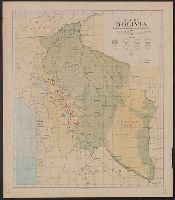
- Published / Created:
- 1912
- Call Number:
- 98g 1912
- Container / Volume:
- BRBL_00679
- Image Count:
- 1
- Resource Type:
- Maps, Atlases & Globes
- Found in:
- Beinecke Rare Book and Manuscript Library > Map of Bolivia : showing forest and agricultural areas, and mineral localities.
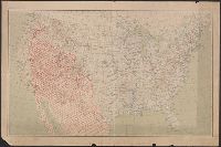
- Published / Created:
- 1909
- Call Number:
- 75cfe 1909
- Container / Volume:
- BRBL_00409
- Image Count:
- 1
- Resource Type:
- Maps, Atlases & Globes
- Found in:
- Beinecke Rare Book and Manuscript Library > United States, Contour Map.
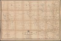
- Creator:
- United States. General Land Office
- Published / Created:
- 1864
- Call Number:
- 75fcm 1864
- Container / Volume:
- BRBL_00410
- Image Count:
- 1
- Resource Type:
- Maps, Atlases & Globes
- Found in:
- Beinecke Rare Book and Manuscript Library > Map of the Public Land States and territories [cartographic material] / constructed from the Public Surveys and other official sources in the General Land Office ; drawn by J.H. Hawes, principal draughtsman [and] T. Franks, assistant.
- Published / Created:
- 1919
- Call Number:
- 75gmb AL14 1919
- Container / Volume:
- BRBL_00411
- Image Count:
- 1
- Resource Type:
- Maps, Atlases & Globes
- Found in:
- Beinecke Rare Book and Manuscript Library > Map of the Albert Pike Highway : showing every city, town, village and hamlet throughout its entire length / proposed by the Albert Pike Highway Association.
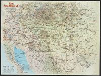
- Creator:
- National Geographic Society (U.S.). Cartographic Section
- Published / Created:
- 1940
- Call Number:
- 7821 1940
- Container / Volume:
- BRBL_00506
- Image Count:
- 1
- Resource Type:
- Maps, Atlases & Globes
- Found in:
- Beinecke Rare Book and Manuscript Library > The southwestern United States / executed in the Cartographic Section of the National geographic magazine ; James M. Darley, chief cartographer ; culture by Apphia E. Holdstock ; research by Wellman Chamberlin ; physiography by John J. Brehm and H.E. East
- Creator:
- National Geographic Society (U.S.). Cartographic Division
- Published / Created:
- c1959
- Call Number:
- 7821 1959
- Container / Volume:
- BRBL_00506
- Image Count:
- 1
- Resource Type:
- Maps, Atlases & Globes
- Found in:
- Beinecke Rare Book and Manuscript Library > Southwestern United States / compiled and drawn in the Cartographic Division of the National Geographic Society for the National geographic magazine ; James M. Darley, chief cartographer.
- Creator:
- National Geographic Society (U.S.). Cartographic Section
- Published / Created:
- 1940
- Call Number:
- 7821 1940
- Container / Volume:
- BRBL_00506
- Image Count:
- 1
- Resource Type:
- Maps, Atlases & Globes
- Found in:
- Beinecke Rare Book and Manuscript Library > The southwestern United States / executed in the Cartographic Section of the National geographic magazine ; James M. Darley, chief cartographer ; culture by Apphia E. Holdstock ; research by Wellman Chamberlin ; physiography by John J. Brehm and H.E. East
- Creator:
- National Geographic Society (U.S.). Cartographic Section
- Published / Created:
- 1948
- Call Number:
- 7821 1948
- Container / Volume:
- BRBL_00506
- Image Count:
- 1
- Resource Type:
- Maps, Atlases & Globes
- Found in:
- Beinecke Rare Book and Manuscript Library > Southwestern United States / compiled and drawn in the Cartographic Section of the National Geographic Society ; James M. Darley, chief cartographer ; compilation by H.C. Bryan, R.W. Collins, R.J. Darley, A.D. Grazzini, and A.E. Holdstock ; relief by John
- Creator:
- National Geographic Society (U.S.). Cartographic Section
- Published / Created:
- 1940
- Call Number:
- 7821 1940
- Container / Volume:
- BRBL_00506
- Image Count:
- 1
- Resource Type:
- Maps, Atlases & Globes
- Found in:
- Beinecke Rare Book and Manuscript Library > The southwestern United States / executed in the Cartographic Section of the National geographic magazine ; James M. Darley, chief cartographer ; culture by Apphia E. Holdstock ; research by Wellman Chamberlin ; physiography by John J. Brehm and H.E. East
- Creator:
- United States. General Land Office
- Published / Created:
- 1907
- Call Number:
- 832 1907
- Container / Volume:
- BRBL_00582
- Image Count:
- 1
- Resource Type:
- Maps, Atlases & Globes
- Found in:
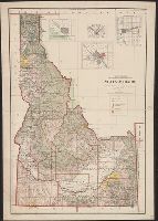
- Beinecke Rare Book and Manuscript Library > State of Idaho : 1907 / compiled from the official records of the General Land Office and other sources under the direction of Frank Bond ; rev. & drawn by Charles J. Helm.
- Creator:
- National Geographic Society (U.S.). Cartographic Division
- Published / Created:
- 1959
- Call Number:
- 848 1959
- Container / Volume:
- BRBL_00631
- Image Count:
- 1
- Resource Type:
- Maps, Atlases & Globes
- Found in:
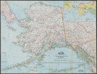
- Beinecke Rare Book and Manuscript Library > State of Alaska / compiled and drawn in the Cartographic Division of the National Geographic Society for the National Geographic Magazine.
- Creator:
- Mulford, John C
- Published / Created:
- 1915
- Call Number:
- 761gmb 1914
- Container / Volume:
- BRBL_00449
- Image Count:
- 1
- Resource Type:
- Maps, Atlases & Globes
- Found in:
- Beinecke Rare Book and Manuscript Library > National Highways map of the state of Maine : showing one thousand three hundred miles of national highways proposed by the National Highways Association, Washington D.C. / John C. Mulford, cartographer ; published under direction of General Coleman du Po
- Published / Created:
- 1915
- Call Number:
- 75gmb 1915
- Container / Volume:
- BRBL_00411
- Image Count:
- 1
- Resource Type:
- Maps, Atlases & Globes
- Found in:
- Beinecke Rare Book and Manuscript Library > National highways map of the United States showing one hundred thousand miles of national highways proposed by the National Highways Association / John C. Mulford, chief cartographer ; published under direction of the National Highways Association.
- Creator:
- National Highways Association
- Published / Created:
- 1913
- Call Number:
- 75gmb 1915B
- Container / Volume:
- BRBL_00411
- Image Count:
- 1
- Resource Type:
- Maps, Atlases & Globes
- Found in:
- Beinecke Rare Book and Manuscript Library > National highways system -- fifty thousand miles -- main trunk and link lines proposed by the National Highways Association / National Highways Association.
- Creator:
- U.S. Coast and Geodetic Survey
- Published / Created:
- 1900
- Call Number:
- 767cea 1900
- Container / Volume:
- BRBL_00476
- Image Count:
- 1
- Resource Type:
- Maps, Atlases & Globes
- Found in:
- Beinecke Rare Book and Manuscript Library > Connecticut River, Deep River to Higganum, Connecticut / U.S. Coast and Geodetic Survey.
- Creator:
- United States. Army. Corps of Engineers
- Published / Created:
- 1940
- Call Number:
- 814 M666 1940
- Container / Volume:
- BRBL_00558
- Image Count:
- 1
- Resource Type:
- Maps, Atlases & Globes
- Found in:
- Beinecke Rare Book and Manuscript Library > Strategic map [of the United States]. Twin Cities sheet.
- Creator:
- United States. Bureau of the Census
- Published / Created:
- 1934
- Call Number:
- 814fb 1930
- Container / Volume:
- BRBL_00559
- Image Count:
- 1
- Resource Type:
- Maps, Atlases & Globes
- Found in:
- Beinecke Rare Book and Manuscript Library > Minnesota, minor civil divisions : 1930 / Department of Commerce, Bureau of the Census.
- Published / Created:
- 1932
- Call Number:
- 848 D42 1932
- Container / Volume:
- BRBL_00632
- Image Count:
- 1
- Resource Type:
- Maps, Atlases & Globes
- Found in:
- Beinecke Rare Book and Manuscript Library > Reconnaissance topographic map of the Dennison Fork district, Alaska.
- Creator:
- Tyrrell, Joseph Burr, 1858-1957
- Published / Created:
- c1897
- Call Number:
- 848 1897E
- Container / Volume:
- BRBL_00630
- Image Count:
- 1
- Resource Type:
- Maps, Atlases & Globes
- Found in:
- Beinecke Rare Book and Manuscript Library > Gold region approaches by Copper River and the Dalton Trail / compiled from latest U.S. surveys, British authorities and other sources by J.B. Tyrrell.
- Published / Created:
- 1929
- Call Number:
- 848 C36 1929
- Container / Volume:
- BRBL_00632
- Image Count:
- 1
- Resource Type:
- Maps, Atlases & Globes
- Found in:
- Beinecke Rare Book and Manuscript Library > Topographic map of Chandalar-Sheenjek region, Alaska.
- Creator:
- National Geographic Society (U.S.). Map Dept
- Published / Created:
- c1922
- Call Number:
- 88cbf 1914
- Container / Volume:
- BRBL_00648
- Image Count:
- 1
- Resource Type:
- Maps, Atlases & Globes
- Found in:
- Beinecke Rare Book and Manuscript Library > The countries of the Caribbean : including Mexico, Central America, the West Indies, and the Panama Canal / prepared especially for the National geographic magazine.
- Creator:
- United States Coast Survey
- Published / Created:
- 1872
- Call Number:
- 764 F195 1872
- Container / Volume:
- BRBL_00457
- Image Count:
- 1
- Resource Type:
- Maps, Atlases & Globes
- Found in:
- Beinecke Rare Book and Manuscript Library > Narraganset Bay : Sheet No. 7.
- Creator:
- United States. Army Map Service
- Published / Created:
- 1947
- Call Number:
- 796 1947A
- Container / Volume:
- BRBL_00526
- Image Count:
- 1
- Resource Type:
- Maps, Atlases & Globes
- Found in:
- Beinecke Rare Book and Manuscript Library > Sabine Pass, Tex., La. / prepared under the direction of the Chief of the Engineers by the Army Map Service (AM), U.S. Army.
- Creator:
- National Geographic Society (U.S.). Cartographic Section
- Published / Created:
- 1954
- Call Number:
- 844 1954
- Container / Volume:
- BRBL_00603
- Image Count:
- 1
- Resource Type:
- Maps, Atlases & Globes
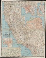
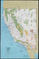
- Found in:
- Beinecke Rare Book and Manuscript Library > A map of California : with descriptive notes / compiled and drawn in the Cartographic Section of the National Geographic Society ; James M. Darley, chief cartographer.
- Creator:
- National Geographic Society (U.S.). Cartographic Section
- Published / Created:
- 1954
- Call Number:
- 844 1954
- Container / Volume:
- BRBL_00603
- Image Count:
- 1
- Resource Type:
- Maps, Atlases & Globes
- Found in:
- Beinecke Rare Book and Manuscript Library > A map of California : with descriptive notes / compiled and drawn in the Cartographic Section of the National Geographic Society ; James M. Darley, chief cartographer.
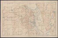
- Published / Created:
- [1909?]
- Call Number:
- 825 L487 1909A
- Container / Volume:
- BRBL_00574
- Image Count:
- 1
- Resource Type:
- Maps, Atlases & Globes
- Found in:
- Beinecke Rare Book and Manuscript Library > Map of Fort Leavenworth, Kansas and vicinity.
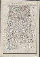
- Creator:
- King, Harry
- Published / Created:
- 1895
- Call Number:
- 793 1895
- Container / Volume:
- BRBL_00520
- Image Count:
- 1
- Resource Type:
- Maps, Atlases & Globes
- Found in:
- Beinecke Rare Book and Manuscript Library > Map of the state of Alabama : compiled from the official records of the General Land Office and other sources / under the direction of Harry King, C.E. Chief of Drafting Division G.L.O.; compiled by Rob[t] H. Morton; revised and drawn by Daniel O'Hare.
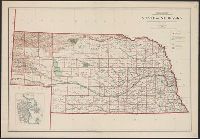
- Creator:
- United States. General Land Office
- Published / Created:
- 1908
- Call Number:
- 824 1908
- Container / Volume:
- BRBL_00570
- Image Count:
- 1
- Resource Type:
- Maps, Atlases & Globes
- Found in:
- Beinecke Rare Book and Manuscript Library > State of Nebraska / Department of the Interior, General Land Office ; compiled from the official records of the General Land Office and other sources under the direction of I.P. Berthrong ; compiled by A.F. Dinsmore ; traced and lettered by Wm. Bauman, Jr
- Creator:
- United States. General Land Office
- Published / Created:
- 1910
- Call Number:
- 834 1910A
- Container / Volume:
- BRBL_00588
- Image Count:
- 1
- Resource Type:
- Maps, Atlases & Globes
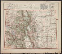
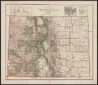
- Found in:
- Beinecke Rare Book and Manuscript Library > State of Colorado : compiled from the official records of the General land office and other sources / compiled by A.F. Dinsmore ; traced and lettered by Wm. Bauman Jr., U.S. General Land Office.
- Creator:
- Dinsmore, A. F
- Published / Created:
- 1905
- Call Number:
- 834 1905
- Container / Volume:
- BRBL_00588
- Image Count:
- 1
- Resource Type:
- Maps, Atlases & Globes
- Found in:
- Beinecke Rare Book and Manuscript Library > State of Colorado : compiled from the official records of the General Land Office and other sources under the direction of Frank Bond / U.S. General Land Office ; compiled by A.F. Dinsmore.
- Published / Created:
- 1900
- Call Number:
- 85 1900
- Container / Volume:
- BRBL_00638
- Image Count:
- 1
- Resource Type:
- Maps, Atlases & Globes
- Found in:
- Beinecke Rare Book and Manuscript Library > The West India Islands : and adjacent territory showing the British possessions south of the United States.
- Published / Created:
- [190?]
- Call Number:
- 28hc 1900A
- Container / Volume:
- BRBL_00024
- Image Count:
- 1
- Resource Type:
- Maps, Atlases & Globes
- Found in:
- Beinecke Rare Book and Manuscript Library > Copy of map furnished to commanding officers, 2nd Brig., 2nd Div., 8th Army Corps, on August 12, 1898.
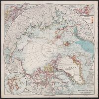
- Creator:
- National Geographic Society (U.S.)
- Published / Created:
- 1907
- Call Number:
- 18 1907
- Container / Volume:
- BRBL_00013
- Image Count:
- 1
- Resource Type:
- Maps, Atlases & Globes
- Found in:
- Beinecke Rare Book and Manuscript Library > The National geographic magazine map of the North Pole regions / prepared by Gilbert H. Grosvenor, editor.
- Creator:
- Bumstead, Albert H. (Albert Hoit), 1875-1940
- Published / Created:
- 1919
- Call Number:
- 30ed 1919
- Container / Volume:
- BRBL_00037B
- Image Count:
- 1
- Resource Type:
- Maps, Atlases & Globes
- Found in:
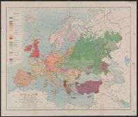
- Beinecke Rare Book and Manuscript Library > Map of the races of Europe and adjoining portions of Asia and Africa / drawn under the direction of Edwin A. Grosvenor and Gilbert Grosvenor in the Map Department of the National Geographic Magazine by Albert H. Bumstead.
- Creator:
- Matthews-Northrup Works
- Published / Created:
- 1915
- Call Number:
- 30 1915
- Container / Volume:
- BRBL_00032
- Image Count:
- 1
- Resource Type:
- Maps, Atlases & Globes
- Found in:
- Beinecke Rare Book and Manuscript Library > Map of Europe and adjoining portions of Africa and Asia / prepared especially for the National Geographic Magazine ... by the Matthews-Northrup Works, Buffalo, N.Y.
- Creator:
- Bumstead, Albert H. (Albert Hoit), 1875-1940
- Published / Created:
- 1919
- Call Number:
- 30ed 1919
- Container / Volume:
- BRBL_00037B
- Image Count:
- 1
- Resource Type:
- Maps, Atlases & Globes
- Found in:
- Beinecke Rare Book and Manuscript Library > Map of the races of Europe and adjoining portions of Asia and Africa / drawn under the direction of Edwin A. Grosvenor and Gilbert Grosvenor in the Map Department of the National Geographic Magazine by Albert H. Bumstead.
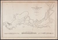
- Published / Created:
- 1911
- Call Number:
- 794gcf B419 1911
- Container / Volume:
- BRBL_00521
- Image Count:
- 1
- Resource Type:
- Maps, Atlases & Globes
- Found in:
- Beinecke Rare Book and Manuscript Library > Map of Belzoni drainage district, Washington County, Mississippi : showing division of the district into units and the proposed system of ditches and channel improvements.
- Creator:
- Mulford, John C
- Published / Created:
- 1915
- Call Number:
- 774gmb 1915
- Container / Volume:
- BRBL_00501A
- Image Count:
- 1
- Resource Type:
- Maps, Atlases & Globes
- Found in:
- Beinecke Rare Book and Manuscript Library > National highways map of the State of Pennsylvania : showing three thousand miles of national highways proposed by the National Highways association / John C. Mulford, cartographer.
- Creator:
- United States. Department of the Treasury. Bureau of Statistics
- Published / Created:
- [1899]
- Call Number:
- BrSides Folio 2019 64
- Image Count:
- 1
- Resource Type:
- Maps, Atlases & Globes
- Found in:
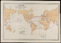
- Beinecke Rare Book and Manuscript Library > Submarine and land telegraph systems of the world [cartographic material].
- Creator:
- La Rocque, George A., 1908-
- Published / Created:
- 1966
- Call Number:
- 817cbj 1966
- Container / Volume:
- BRBL_00564
- Image Count:
- 1
- Resource Type:
- Maps, Atlases & Globes
- Found in:
- Beinecke Rare Book and Manuscript Library > General availability of ground water and depth to water level in the Missouri River Basin / by G.A. La Rocque, Jr.
- Creator:
- National Geographic Society (U.S.)
- Published / Created:
- 1905
- Call Number:
- 899 1905
- Container / Volume:
- BRBL_00660
- Image Count:
- 1
- Resource Type:
- Maps, Atlases & Globes
- Found in:
- Beinecke Rare Book and Manuscript Library > Map showing location of Panama Canal : as recommended by the Isthmian Canal Commission of 1899-1902 / supplement to the National Geographic Magazine.
- Creator:
- Great Britain. War Office
United States. Army Map Service
- Published / Created:
- 1941-
- Call Number:
- 343CBF 1941
- Container / Volume:
- BRBL_00093
- Image Count:
- 4
- Resource Type:
- Maps, Atlases & Globes
- Found in:
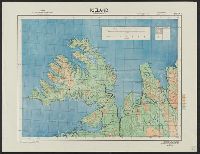
- Beinecke Rare Book and Manuscript Library > Iceland 1:500,000.
- Creator:
- Bontz, Geo. F
United States. War Dept. General Staff. War College Division
Williams, Arch. B
- Published / Created:
- 1915
- Call Number:
- 304fab 1915
- Container / Volume:
- BRBL_00034B
- Image Count:
- 4
- Resource Type:
- Maps, Atlases & Globes
- Found in:
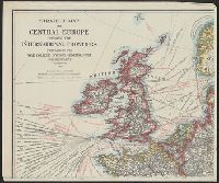
- Beinecke Rare Book and Manuscript Library > Strategic map of Central Europe showing the international frontiers / prepared in the War College Division, General Staff, War Department ; Arch. B. Williams and Geo. F. Bontz, Draftsmen.
- Creator:
- United States. Bureau of Naval Personnel. Educational Services Section
- Published / Created:
- 1944
- Call Number:
- 5819hc 1944
- Container / Volume:
- BRBL_00314
- Image Count:
- 4
- Resource Type:
- Maps, Atlases & Globes
- Found in:
- Beinecke Rare Book and Manuscript Library > The South China Sea area.
- Creator:
- United States. Army Map Service
- Published / Created:
- 1943
- Call Number:
- 556 1944D
- Container / Volume:
- BRBL_00293
- Image Count:
- 2
- Resource Type:
- Maps, Atlases & Globes
- Found in:
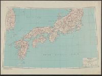
- Beinecke Rare Book and Manuscript Library > Eastern Asia 1:1,000,000 [cartographic material] : AAF cloth chart. Hakodate. NK54.
- Creator:
- United States. Army Map Service
- Published / Created:
- 1944
- Call Number:
- 556 1943
- Container / Volume:
- BRBL_00293
- Image Count:
- 2
- Resource Type:
- Maps, Atlases & Globes
- Found in:
- Beinecke Rare Book and Manuscript Library > Harbin [cartographic material] / prepared under the direction of the Chief of Engineers, U.S. Army, by the Army Map Service.
- Creator:
- United States. Army Map Service
- Published / Created:
- 1944
- Call Number:
- 57gmb 1943
- Container / Volume:
- BRBL_00307
- Image Count:
- 2
- Resource Type:
- Maps, Atlases & Globes
- Found in:
- Beinecke Rare Book and Manuscript Library > Japan (South) : special strategic map / compiled by the Army Map Service, May 1943.
- Creator:
- United States. Army Map Service
- Published / Created:
- [1943?]
- Call Number:
- 60gmb 1945
- Container / Volume:
- BRBL_00330
- Image Count:
- 2
- Resource Type:
- Maps, Atlases & Globes
- Found in:
- Beinecke Rare Book and Manuscript Library > Index map of Africa road maps, scale various.
- Creator:
- United States. Army Map Service
- Published / Created:
- 1944
- Call Number:
- 596gms 1944
- Container / Volume:
- BRBL_00320
- Image Count:
- 2
- Resource Type:
- Maps, Atlases & Globes
- Found in:
- Beinecke Rare Book and Manuscript Library > South Burma ; North Burma / compiled for the U.S. Army Air Forces by the Army Map Service (LC), U.S. Army.
- Creator:
- Great Britain. Royal Air Force. Central Interpretation Unit
- Published / Created:
- 1944
- Call Number:
- 40 R66 1944
- Container / Volume:
- BRBL_00219
- Image Count:
- 2
- Resource Type:
- Maps, Atlases & Globes
- Found in:
- Beinecke Rare Book and Manuscript Library > Town plan of Roma (Rome) [cartographic material] / drawn by C.I.U. and War Office.
- Creator:
- National Geographic Society (U.S.). Cartographic Division
- Published / Created:
- c1992.
- Call Number:
- 739 1992
- Container / Volume:
- BRBL_00389
- Image Count:
- 2
- Resource Type:
- Maps, Atlases & Globes
- Found in:
- Beinecke Rare Book and Manuscript Library > The making of Canada. British Columbia / produced by the Cartographic Division, National Geographic Society ; John F. Shupe, chief cartographer.
- Creator:
- Corbett, V. P
- Published / Created:
- 1861
- Call Number:
- 754hc B87 1862
- Container / Volume:
- BRBL_00422
- Image Count:
- 1
- Resource Type:
- Maps, Atlases & Globes
- Found in:
- Beinecke Rare Book and Manuscript Library > Map of the seat of war : showing the battles of July 18th & 21st, 1861 / published by V.P. Corbett.
- Creator:
- United States. Army. Signal Corps
- Published / Created:
- 1872
- Call Number:
- 75CF 1872
- Container / Volume:
- BRBL_00409
- Image Count:
- 1
- Resource Type:
- Maps, Atlases & Globes
- Found in:
- Beinecke Rare Book and Manuscript Library > War Department weather map / published by authority of the Secretary of War.
- Creator:
- National Geographic Society (U.S.). Cartographic Section
- Published / Created:
- 1950
- Call Number:
- 80 1950
- Container / Volume:
- BRBL_00536
- Image Count:
- 1
- Resource Type:
- Maps, Atlases & Globes
- Found in:
- Beinecke Rare Book and Manuscript Library > Northwestern United States and neighboring Canadian provinces / compiled and drawn in the Cartographic Section of the National Geographic Society for the National geographic magazine ; James M. Darley, chief cartographer.
- Creator:
- National Geographic Society (U.S.). Cartographic Division
- Published / Created:
- 1960
- Call Number:
- 845 1960
- Container / Volume:
- BRBL_00620
- Image Count:
- 1
- Resource Type:
- Maps, Atlases & Globes
- Found in:
- Beinecke Rare Book and Manuscript Library > Northwestern United States / compiled and drawn in the Cartographic Division of the National Geographic Society for the National Geographic Magazine.
- Creator:
- National Geographic Society (U.S.). Cartographic Section
- Published / Created:
- 1950
- Call Number:
- 845 1950
- Container / Volume:
- BRBL_00620
- Image Count:
- 1
- Resource Type:
- Maps, Atlases & Globes
- Found in:
- Beinecke Rare Book and Manuscript Library > Northwestern United States and neighboring Canadian provinces / compiled and drawn in the Cartographic Section of the National Geographic Society for the National Geographic Magazine ; James M. Darley, chief cartographer.
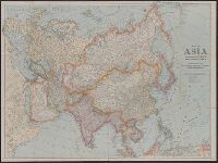
- Creator:
- National Geographic Society (U.S.)
- Published / Created:
- c1921.
- Call Number:
- 50 1921
- Container / Volume:
- BRBL_00273
- Image Count:
- 1
- Resource Type:
- Maps, Atlases & Globes
- Found in:
- Beinecke Rare Book and Manuscript Library > Map of Asia and adjoining Europe with a portion of Africa / prepared especially for the National Geographic Magazine, Gilbert Grosvenor, editor.
- Published / Created:
- [1898]
- Call Number:
- 855hc 1898I
- Container / Volume:
- BRBL_00765
- Image Count:
- 1
- Resource Type:
- Maps, Atlases & Globes
- Found in:
- Beinecke Rare Book and Manuscript Library > Sketch showing a portion of the trenches occupied by Bates' brigade also the Spanish opposing works / drawn from the trenches by Lieutenant Horace Maynard Reeve, 3d Inf. Engineer, Provisional brigade, 5th Corps.
- Published / Created:
- [1898]
- Call Number:
- 855hc 1898P
- Container / Volume:
- BRBL_00765
- Image Count:
- 1
- Resource Type:
- Maps, Atlases & Globes
- Found in:
- Beinecke Rare Book and Manuscript Library > Sketch showing the operations of the command of Brigadier General John C. Bates in the campaign against Santiago de Cuba / drawn by Lieutenant Horace Maynard Reeve, 3d Inf., Engineer Officer, Provisional brigade, Fifth Corps.
- Creator:
- United States. Adjutant-General's Office. Military Information Division
- Published / Created:
- [1898]
- Call Number:
- 855hc 1898J
- Container / Volume:
- BRBL_00765
- Image Count:
- 1
- Resource Type:
- Maps, Atlases & Globes
- Found in:
- Beinecke Rare Book and Manuscript Library > Military map, island of Puerto Rico, 1898 / drawn by W. Morey Jr. C.E.
- Creator:
- United States. Adjutant-General's Office. Military Information Division
- Published / Created:
- [1898]
- Call Number:
- 855hc 1898G
- Container / Volume:
- BRBL_00765
- Image Count:
- 1
- Resource Type:
- Maps, Atlases & Globes
- Found in:
- Beinecke Rare Book and Manuscript Library > Map of battle field of August 10th 1898 : between U.S. regular troops under Brig. Genl. Theodore Schwan, U.S. Volunteers and Spanish forces under Col. Julio Soto Villanueva, Alfonso XIII.
- Published / Created:
- [1898]
- Call Number:
- 855hc 1898M
- Container / Volume:
- BRBL_00765
- Image Count:
- 1
- Resource Type:
- Maps, Atlases & Globes
- Found in:
- Beinecke Rare Book and Manuscript Library > Santiago de Cuba Position of American, Cuban, and Spanish forces on July 14th, 1898.
- Published / Created:
- 1898
- Call Number:
- 855hc 1898D
- Container / Volume:
- BRBL_00765
- Image Count:
- 1
- Resource Type:
- Maps, Atlases & Globes
- Found in:
- Beinecke Rare Book and Manuscript Library > Preliminary map of Camp Meade Middletown, PA, Office of Chief Engineer 2nd Army Corps.
- Published / Created:
- [1898]
- Call Number:
- 855hc 1898N
- Container / Volume:
- BRBL_00765
- Image Count:
- 1
- Resource Type:
- Maps, Atlases & Globes
- Found in:
- Beinecke Rare Book and Manuscript Library > Santiago de Cuba Position of Cuban and Spanish forces prior to July 3rd, 1898.
- Published / Created:
- [1898]
- Call Number:
- 855hc 1898O
- Container / Volume:
- BRBL_00765
- Image Count:
- 1
- Resource Type:
- Maps, Atlases & Globes
- Found in:
- Beinecke Rare Book and Manuscript Library > Map of Santiago de Cuba showing intrenchments and position of the 5th Corps. U.S. Army and those of the Spanish / compiled from partial transit surveys and foot reconnaisance notes and sketches by Lts. Guy, Smith, Cordray. of the Inf.; Lts. Batson and G.P
- Published / Created:
- [1898]
- Call Number:
- 855hc 1898L
- Container / Volume:
- BRBL_00765
- Image Count:
- 1
- Resource Type:
- Maps, Atlases & Globes
- Found in:
- Beinecke Rare Book and Manuscript Library > Map of Santiago de Cuba showing intrenchments and positions of the Fifth Corps. U.S. Army and those of the Spanish after the taking of Caney and San Juan Hill, evening of July 1st, 1898 / compiled from partial transit surveys and foot reconnaisance notes
- Creator:
- United States. Adjutant-General's Office. Military Information Division
- Published / Created:
- [1898]
- Call Number:
- 855hc 1898A
- Container / Volume:
- BRBL_00765
- Image Count:
- 1
- Resource Type:
- Maps, Atlases & Globes
- Found in:
- Beinecke Rare Book and Manuscript Library > Map of Puerto Rico showing line of march of General Schwan's expedition from Ponce and Yauco to crossing of Rio Prieto August 9-15, 1898 / Chas. H. Ourand.
- Published / Created:
- 1898
- Call Number:
- 855hc 1898F
- Container / Volume:
- BRBL_00765
- Image Count:
- 1
- Resource Type:
- Maps, Atlases & Globes
- Found in:
- Beinecke Rare Book and Manuscript Library > Sketch map of Camp Alger, VA including new camp of 1st Div. 2nd Corps near Dunn Loring, 1898.
- Creator:
- United States. Adjutant-General's Office. Military Information Division
- Published / Created:
- [1898]
- Call Number:
- 855hc 1898B
- Container / Volume:
- BRBL_00765
- Image Count:
- 1
- Resource Type:
- Maps, Atlases & Globes
- Found in:
- Beinecke Rare Book and Manuscript Library > Road sketch showing the marches of the independent brigade VI corps (Bates') from Siboney to Elcaney and th position before Santiago.
- Creator:
- United States. Adjutant-General's Office. Military Information Division
- Published / Created:
- [1898]
- Call Number:
- 855hc 1898K
- Container / Volume:
- BRBL_00765
- Image Count:
- 1
- Resource Type:
- Maps, Atlases & Globes
- Found in:
- Beinecke Rare Book and Manuscript Library > Sketch showing movements and positions of troops in the affair of August 9th 1898 at Coamo, Puerto Rico : August 21, 1898, scale 1000' to 1' / Sergt. S.H. Knight, topographer.
- Creator:
- United States. Adjutant-General's Office. Military Information Division
- Published / Created:
- [1898]
- Call Number:
- 855hc 1898
- Container / Volume:
- BRBL_00642
- Image Count:
- 1
- Resource Type:
- Maps, Atlases & Globes
- Found in:
- Beinecke Rare Book and Manuscript Library > Sketch map of Guayama and vicinity showing location of Spanish strongholds, and route of March made by Brig. Gen. Hains on Aug 13, 1898.
- Published / Created:
- .
- Call Number:
- 5684 1905
- Container / Volume:
- BRBL_00300
- Image Count:
- 1
- Resource Type:
- Maps, Atlases & Globes
- Found in:
- Beinecke Rare Book and Manuscript Library > The Regent's Sword Peninsula.
- Published / Created:
- 1909
- Call Number:
- 60g 1909
- Container / Volume:
- BRBL_00329
- Image Count:
- 1
- Resource Type:
- Maps, Atlases & Globes
- Found in:
- Beinecke Rare Book and Manuscript Library > The National Geographic Magazine map of Africa / prepared from latest geographical data by Gilbert H. Grosvenor, Editor.
- Creator:
- National Geographic Society (U.S.). Cartographic Division
- Published / Created:
- 1982
- Call Number:
- 7821 1982
- Container / Volume:
- BRBL_00506
- Image Count:
- 2
- Resource Type:
- Maps, Atlases & Globes
- Found in:
- Beinecke Rare Book and Manuscript Library > The Southwest / produced by the Cartographic Division, National Geographic Society ; John B. Garver, Jr., chief cartographer.
- Creator:
- National Geographic Society (U.S.). Cartographic Division
- Published / Created:
- 1986
- Call Number:
- 8101 1986
- Container / Volume:
- BRBL_00552
- Image Count:
- 2
- Resource Type:
- Maps, Atlases & Globes
- Found in:
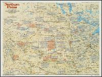
- Beinecke Rare Book and Manuscript Library > Northern Plains / produced by the Cartographic Division, National Geographic Society ... ; John B. Garver, Jr., chief cartographer ; John F. Shupe, associate chief.
- Creator:
- National Geographic Society (U.S.). Cartographic Division
- Published / Created:
- 1986
- Call Number:
- 8101 1986
- Container / Volume:
- BRBL_00552
- Image Count:
- 2
- Resource Type:
- Maps, Atlases & Globes
- Found in:
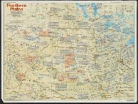
- Beinecke Rare Book and Manuscript Library > Northern Plains / produced by the Cartographic Division, National Geographic Society ... ; John B. Garver, Jr., chief cartographer ; John F. Shupe, associate chief.
- Creator:
- United States. Post Office Dept
- Published / Created:
- [1883]
- Call Number:
- 831gmd 1883
- Container / Volume:
- BRBL_00581
- Image Count:
- 2
- Resource Type:
- Maps, Atlases & Globes
- Found in:
- Beinecke Rare Book and Manuscript Library > Post route map of the territories of Montana, Idaho, and Wyoming with parts of adjacent states and territories : showing post offices with intermediate distances between them and mail routes in operation on 1st October 1883 / published by order of Postmas
- Creator:
- National Geographic Society (U.S.). Cartographic Division
- Published / Created:
- 1986
- Call Number:
- 796 1986
- Container / Volume:
- BRBL_00526
- Image Count:
- 2
- Resource Type:
- Maps, Atlases & Globes
- Found in:
- Beinecke Rare Book and Manuscript Library > Texas / produced by the Cartographic Division, National Geographic Society.
- Creator:
- National Geographic Society (U.S.). Cartographic Division
- Published / Created:
- c1977.
- Call Number:
- 7821 1977
- Container / Volume:
- BRBL_00506
- Image Count:
- 2
- Resource Type:
- Maps, Atlases & Globes
- Found in:
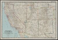
- Beinecke Rare Book and Manuscript Library > Close-up: U.S.A., the Southwest / produced by the Cartographic Division, National Geographic Society ; William T. Peele, chief cartographer ; Richard K. Rogers, assistant chief cartographer.
- Creator:
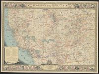
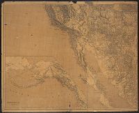
- Freyhold, Edward
- Published / Created:
- 1879
- Call Number:
- 80 1879
- Container / Volume:
- BRBL_00536
- Image Count:
- 2
- Resource Type:
- Maps, Atlases & Globes
- Found in:
- Beinecke Rare Book and Manuscript Library > Map of the territory of the United States, west of the Mississippi River / prepared by authority of the Hon. the Secretary of War, in the office of the Chief of Engineers under the direction of Brig. Gen. A.A. Humphreys, Chief of Engrs. Bvt. Major General
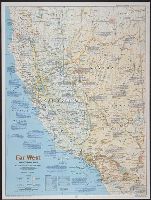
- Creator:
- National Geographic Society (U.S.). Cartographic Division
- Published / Created:
- 1984
- Call Number:
- 80 1984
- Container / Volume:
- BRBL_00536
- Image Count:
- 2
- Resource Type:
- Maps, Atlases & Globes
- Found in:
- Beinecke Rare Book and Manuscript Library > Far West / produced by the Cartographic Division, National Geographic Society.
- Creator:
- United States. Post Office Dept
- Published / Created:
- 1883
- Call Number:
- 821gmd 1883
- Container / Volume:
- BRBL_00566
- Image Count:
- 2
- Resource Type:
- Maps, Atlases & Globes
- Found in:
- Beinecke Rare Book and Manuscript Library > Post route map of the territory of Dakota with adjacent parts of Montana, Wyoming, Nebraska, Iowa and Minnesota : and portions of the Dominion of Canada, showing post offices with the intermediate distances between them and mail routes in operation on 1st
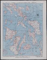
- Creator:
- United States. Army Air Forces
- Published / Created:
- 1944
- Call Number:
- 50 1945C
- Container / Volume:
- BRBL_00273
- Image Count:
- 2
- Resource Type:
- Maps, Atlases & Globes
- Found in:
- Beinecke Rare Book and Manuscript Library > AAF cloth chart [cartographic material] : no. C41, Mindoro Island / Army Map Service U.S. Army.
- Creator:
- National Geographic Society (U.S.). Cartographic Division
- Published / Created:
- c1989.
- Call Number:
- 833 Y38 1989
- Container / Volume:
- BRBL_00584
- Image Count:
- 2
- Resource Type:
- Maps, Atlases & Globes
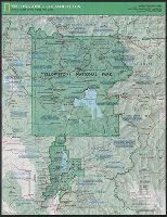
- Found in:
- Beinecke Rare Book and Manuscript Library > Yellowstone and Grand Teton / produce by the Cartographic Division, National Geographic Society ; John B. Garver, Jr., chief cartographer.
- Creator:
- National Geographic Society (U.S.). Cartographic Division
- Published / Created:
- c1978.
- Call Number:
- 844 1978
- Container / Volume:
- BRBL_00603
- Image Count:
- 2
- Resource Type:
- Maps, Atlases & Globes
- Found in:
- Beinecke Rare Book and Manuscript Library > Close-up: U.S.A., California and Nevada / produced by the Cartographic Division, National Geographic Society ; William T. Peele, chief cartographer, David W. Cook, associate chief cartographer.
- Creator:
- Westgard, A. L. (Anthon L.), b. 1865
- Published / Created:
- c1920.
- Call Number:
- 847gmb 1920A
- Container / Volume:
- BRBL_00629
- Image Count:
- 2
- Resource Type:
- Maps, Atlases & Globes
- Found in:
- Beinecke Rare Book and Manuscript Library > Washington and Oregon / prepared and issued by Touring Information Board, American Automobile Association ; prepared by A.L. Westgard, field representative, American Automobile Association ; F.S.R. jr.
- Published / Created:
- 1917
- Call Number:
- 762gcr W588 1917
- Container / Volume:
- BRBL_00451
- Image Count:
- 2
- Resource Type:
- Maps, Atlases & Globes
- Found in:
- Beinecke Rare Book and Manuscript Library > White Mountain National Forest, New Hampshire and Maine / U.S. Department of Agriculture, Forest Service, Henry S. Graves, Forester.