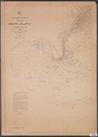
[Maury map collection ; Series D1], Maury's wind & current chart : thermal sheet., North Atlantic, and Thermal sheet
Description:
"Series D.", DLC, Includes notes in map area and signature of M.F. Maury., Sheet 1 (1850), 3 copies -- Sheet 1 (1852) -- Sheet 2, 2 copies -- Sheet 3, 3 copies -- Sheet 4, 3, Shows temperature of the water at the surface by month., and Various eds. of some sheets.
Publisher:
United States Hydrographical Office,
Subject (Geographic):
North Atlantic Ocean--Maps
Subject (Name):
Gantt, Benjamin S., -1852, Maury, Matthew Fontaine, 1806-1873. Wind and current charts, United States Naval Observatory, United States. Bureau of Ordnance and Hydrography, United States. Hydrographic Office, and Warrington, L. (Lewis), 1782-1851
Subject (Topic):
Nautical charts--North Atlantic Ocean and Ocean temperature--North Atlantic Ocean--Maps
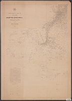
[Maury map collection ; Series D1], Maury's wind & current chart : thermal sheet., North Atlantic, and Thermal sheet
Description:
Copy imperfect: Sheet torn and repaired along fold-line and edges. Discoloration throughout., Each sheet numbered in upper left margin, e.g.: 14, 15., Includes notes in map area and signature of M.F. Maury., and Sheet 1 (1850), 3 copies -- Sheet 1 (1852) -- Shee
Publisher:
United States Hydrographical Office,
Subject (Geographic):
North Atlantic Ocean--Maps
Subject (Name):
Gantt, Benjamin S., -1852, Maury, Matthew Fontaine, 1806-1873. Wind and current charts, United States Naval Observatory, United States. Bureau of Ordnance and Hydrography, United States. Hydrographic Office, and Warrington, L. (Lewis), 1782-1851
Subject (Topic):
Nautical charts--North Atlantic Ocean and Ocean temperature--North Atlantic Ocean--Maps
[Maury map collection ; Series D1], Maury's wind & current chart : thermal sheet., North Atlantic, and Thermal sheet
Description:
Copy imperfect: Sheet torn and repaired along fold-line and edges. Discoloration throughout., Each sheet numbered in upper left margin, e.g.: 14, 15., and Sheet 1 (1850), 3 copies -- Sheet 1 (1852) -- Sheet 2, 2 copies -- Sheet 3, 3 copies -- Sheet 4, 3 copies
Publisher:
United States Hydrographical Office,
Subject (Geographic):
North Atlantic Ocean--Maps
Subject (Name):
Gantt, Benjamin S., -1852, Maury, Matthew Fontaine, 1806-1873. Wind and current charts, United States Naval Observatory, United States. Bureau of Ordnance and Hydrography, United States. Hydrographic Office, and Warrington, L. (Lewis), 1782-1851
Subject (Topic):
Nautical charts--North Atlantic Ocean and Ocean temperature--North Atlantic Ocean--Maps
[Maury map collection ; Series D1], Maury's wind & current chart : thermal sheet., North Atlantic, and Thermal sheet
Description:
DLC, Each sheet numbered in upper left margin, e.g.: 14, 15., Includes notes in map area and signature of M.F. Maury., Shows temperature of the water at the surface by month., and Thermal charts were released as series D a part of Maury's "Wind and current charts
Publisher:
United States Hydrographical Office,
Subject (Geographic):
North Atlantic Ocean--Maps
Subject (Name):
Gantt, Benjamin S., -1852, Maury, Matthew Fontaine, 1806-1873. Wind and current charts, United States Naval Observatory, United States. Bureau of Ordnance and Hydrography, United States. Hydrographic Office, and Warrington, L. (Lewis), 1782-1851
Subject (Topic):
Nautical charts--North Atlantic Ocean and Ocean temperature--North Atlantic Ocean--Maps