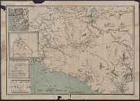
Includes ill., inset of "Klondike River and affluents," and distance table. and Relief shown by hachures and spot heights. Depths shown in fathoms.
Publisher:
J.B. Tyrrell,
Subject (Geographic):
Copper River Region (Alaska)--Maps and Yukon Territory--Maps
Subject (Name):
Andrew B. Graham Co
Subject (Topic):
Copper River Region (Alaska)--Gold discoveries--Maps, Trails--Alaska--Copper River Region--Maps, Trails--Yukon Territory--Maps, and Yukon Territory--Gold discoveries--Maps
In lower left margin: Andrew B. Graham Co., lithographers, Washington, D.C., In lower right margin: Oliver B. Harden del., Includes notes and profile of canal., Oriented with north toward upper left., Relief shown by contours and hachures. Depths shown by soundings., and Supplement to National Geographic, October 1905.
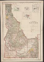
Shows township, railroad & county lines, forest, military & Indian reservations, etc.
Description:
Insets: Boise and vicinity -- Pocatello and vicinity -- Wallace and vicinity -- Lewiston and vicinity., Prime meridians: Greenwich and Washington., and Relief shown by shading.
Publisher:
General Land Office,
Subject (Geographic):
Idaho--Maps
Subject (Name):
Andrew B. Graham Co, Bond, Frank, 1856-1940, and Helm, Charles J