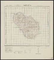
Great Britain. War Office. General Staff. Geographical Section
Published / Created:
1943
Call Number:
40 P19 1942
Container / Volume:
BRBL_00213
Image Count:
1
Resource Type:
Maps, Atlases & Globes
Alternative Title:
Geographical Section, General Staff ; no. 4162 and GSGS (Series) ; 4162.
Description:
"3-43.", "Copied from an Italian map of 1896.", "Grid added November 1942.", Military grid., and Relief shown by contours, rock drawings, and spot heights.
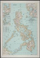
Bouma, Donald G Brehm, John J. B Darley, James M. (James Morrison) Holdstock, A. E National Geographic Society (U.S.). Cartographic Division
Published / Created:
1945
Call Number:
28 1945
Container / Volume:
BRBL_00023E
Image Count:
1
Resource Type:
Maps, Atlases & Globes
Description:
Copy 1: Mounted on linen., Insets: Location map of the Philippines. Scale 1:40,000,000 -- Lingayen, Table: Philippine provinces and their capital cities., and Topographic map with relief shown by hachures and spot heights; elevations and depths in feet.
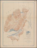
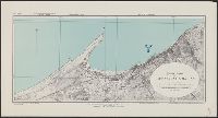
"A.M.S. 5301.", Cloth map (silk)., For further information see a Web site devoted to the history and identification of the AAF cloth maps., Heights and depths in meters., Includes: Index to boundarie, and Relief shown by gradient tints, contours, and spot heights.
Publisher:
Amy Map Service,
Subject (Geographic):
East Asia--Maps
Subject (Name):
United States. Army Map Service
Subject (Topic):
Military geography--Japan--Kagoshima--Maps, Military geography--Japan--Nagasaki--Maps, Military maps, Military topography--Japan--Kagoshima--Maps, and Military topography--Japan--Nagasaki--Maps