Skip to search
Skip to main content
Skip to first result
Search
You Searched For
Format
cartographic
Genre
Maps
Publication Place
Washington :
New Search
Search Results
Creator:
Published / Created:
1906
Call Number:
565 1906
Container / Volume:
BRBL_00299
Image Count:
1
Resource Type:
Maps, Atlases & Globes
Description:
"Drawn by Chas. L. Hoopes.", Inset is continuation of main map., Inset: southern Korea, Korea Strait, northern Japan. Scale [ca. 1:3,960,000]., Relief shown by shading., and Shows boundaries between Manchuria and northern Korea, Mongolia and Siberia at the end of the Russo-Japanese War. Indicates railroads and submarine cables.
Publisher:
Second Division, General Staff,
Subject (Geographic):
Korea--Maps and Manchuria (China)--Maps
Subject (Name):
Hoopes, Charles L
Found in:
Beinecke Rare Book and Manuscript Library > Strategical map of part of Korea and Manchuria / prepared by the Second Division, General Staff (Military Information Division), War Department.
Creator:
Published / Created:
1944
Call Number:
575 Su75 1944
Container / Volume:
BRBL_00312
Image Count:
1
Resource Type:
Maps, Atlases & Globes
Alternative Title:
Its A.M.S. ; L991 and Series (Standard map series designation system) ; S6201.
Description:
"Approximate contour interval 10 meters.", "Place names are transcribed according to the modified Hepburn (Romaji) system.", "Polyconic projection.", At head of title: Formosa city plans ..., Includes "Glossary.", and Marginal maps and diagrams: Index to boundarie
Publisher:
Army Map Service,
Subject (Geographic):
Su-ao (Taiwan)--Maps
Found in:
Beinecke Rare Book and Manuscript Library > Suo / prepared under the direction of the Chief of Engineers by the Army Map Service.
Creator:
Published / Created:
1945
Call Number:
575 T14 1945
Container / Volume:
BRBL_00313
Image Count:
1
Resource Type:
Maps, Atlases & Globes
Alternative Title:
Its A.M.S. ; L991 and Series (Standard map series designation system) ; L991.
Description:
"Contour interval 10 meters.", "Place names are transcribed according to the modified Hepburn (Romaji) system.", "Polyconic projection.", In upper margin: Formosa city plans., Includes "Glossary.", Insets: Index to boundaries.--Coverage diagram., and Military grid.
Publisher:
Army Map Service,
Subject (Geographic):
Takao-shū (Taiwan)--Maps
Found in:
Beinecke Rare Book and Manuscript Library > Takao, Takao-shu, Formosa (Taiwan) / prepared under the direction of the Chief of Engineers by the Army Map Service.
Creator:
Published / Created:
1882
Call Number:
821 1882
Container / Volume:
BRBL_00566
Image Count:
1
Resource Type:
Maps, Atlases & Globes
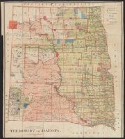
Description:
"N.C. McFarland, Commissioner.", Relief shown by hachures., and Shows Indian and military reservations.
Publisher:
General Land Office,
Subject (Geographic):
Dakota Territory--Historical geography--Maps, North Dakota--Historical geography--Maps, and South Dakota--Historical geography--Maps
Subject (Name):
Roeser, C. (Charles)
Found in:
Beinecke Rare Book and Manuscript Library > Territory of Dakota / compiled from the official records of the General Land Office and other sources by C. Roeser, Principal Draughtsman, G.L.O., Department of the Interior.
Creator:
Published / Created:
1942
Call Number:
30 1942
Container / Volume:
BRBL_00032B
Image Count:
1
Resource Type:
Maps, Atlases & Globes
Description:
Includes airline distance chart. and Relief shown by hypsometric tints and spot heights.
Publisher:
The Society,
Subject (Topic):
World War, 1939-1945--Maps
Found in:
Beinecke Rare Book and Manuscript Library > Theater of war in Europe, Africa and Western Asia [cartographic material] / compiled and drawn in the Cartographic Section of the National Geographic Society for the National Geographic Magazine; James M. Darley, chief cartographer.
Published / Created:
1829
Call Number:
792cea T63 1829
Container / Volume:
BRBL_00715
Image Count:
1
Resource Type:
Maps, Atlases & Globes
Description:
Color: blue with some yellow detail. and Positions of shipwrecks inserted by hand.
Publisher:
US Navy Dept.,]
Subject (Geographic):
Florida--Maps, Manuscript
Found in:
Beinecke Rare Book and Manuscript Library > Tortugas Islands, surveyed by order of the Navy Dept. by Lieut. J. Tatnell & TR Gedney US Navy 1829.
Creator:
Published / Created:
1943
Call Number:
40 AN21 1944
Container / Volume:
BRBL_00203
Image Count:
1
Resource Type:
Maps, Atlases & Globes
Alternative Title:
Geographical Section, General Staff; no. 4380 and GSGS (Series) ; 4380.
Description:
"Contours at 10 metre intervals.", Important streets and buildings are named., In upper margin: Italy 1:5,000 ..., and Military grid.
Publisher:
Army Map Service, U.S. Army,
Subject (Geographic):
Ancona (Italy)--Maps
Subject (Name):
Great Britain. Inter-service Topographical Dept
Found in:
Beinecke Rare Book and Manuscript Library > Town plan of Ancona [cartographic material] / compiled and drawn by by C. I. U., ground information supplied by I. S. T. D.
Creator:
Published / Created:
1943
Call Number:
40 B639 1943
Container / Volume:
BRBL_00205
Image Count:
1
Resource Type:
Maps, Atlases & Globes
Alternative Title:
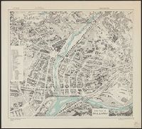
Geographical Section, General Staff ; no. 4380 and GSGS (Series) ; 4380.
Description:
"Copied from an Italian plan dated 1936.", Birds-eye view., Important buildings and streets are named., and In upper margin: Italy ...
Publisher:
Army Map Service, U.S. Army,
Subject (Geographic):
Bolzano (Trentino-Alto Adige, Italy)--Maps
Found in:
Beinecke Rare Book and Manuscript Library > Town plan of Bolzano [cartographic material].
Creator:
Published / Created:
1943
Call Number:
40 F66 1943
Container / Volume:
BRBL_00207
Image Count:
1
Resource Type:
Maps, Atlases & Globes
Alternative Title:
Geographical Section, General Staff ; no. 4380 and GSGS (Series) ; 4380.
Description:
In upper margin: Italy ..., Military grid., and Most streets are named.
Publisher:
Army Map Service, U.S. Army,
Subject (Geographic):
Florence (Italy)--Maps
Found in:
Beinecke Rare Book and Manuscript Library > Town plan of Florence (Firenze) [cartographic material].
Creator:
Published / Created:
1943
Call Number:
40 M72 1943
Container / Volume:
BRBL_00211
Image Count:
1
Resource Type:
Maps, Atlases & Globes
Alternative Title:
Geographical Section, General Staff ; no. 4380 and GSGS (Series) ; 4380.
Description:
Important streets and buildings are named., In upper margin: Italy ..., and Military grid.
Publisher:
Army Map Service, U.S. Army,
Subject (Geographic):
Modena (Italy)--Maps
Found in:
Beinecke Rare Book and Manuscript Library > Town plan of Modena [cartographic material] / drawn by War Office, 1942.
Branch:v1.61.6 ,Deployed:2024-06-12T09:55:31-04:00