Skip to search
Skip to main content
Skip to first result
Search
You Searched For
Access
Public
Format
cartographic
Publication Place
Washington :
New Search
Search Results
Creator:
Published / Created:
1943
Call Number:
44gm 1943
Container / Volume:
BRBL_00257
Image Count:
1
Resource Type:
Maps, Atlases & Globes
Alternative Title:
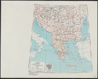
Its A.M.S. ; 6201 and Series (Standard map series designation system) ; 6201.
Description:
"Lambert conformal conic projection.", Elevations are shown by hachures and spot heights in meters., Inset shows area with detailed transportation information., and Two classes of roads and five classes of railroads are shown.
Publisher:
Army Map Service,
Subject (Geographic):
Balkan Peninsula--Maps
Subject (Topic):
Transportation--Balkan Peninsula--Maps
Found in:
Beinecke Rare Book and Manuscript Library > Balkans [cartographic material] : special strategic map compiled by the Army Map Service.
Creator:
Published / Created:
1943
Call Number:
39 B23 1943
Container / Volume:
BRBL_00189
Image Count:
1
Resource Type:
Maps, Atlases & Globes
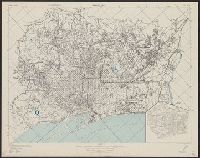
Alternative Title:
[Series] M981.
Description:
"Copied from a Spanish map, 1:14,000, Plano de Barcelona.", At head of title: Spain 1:14,000., Includes inset., Military grid., and Standard map series designation: M981.
Publisher:
Army Map Service, U.S. Army,
Subject (Geographic):
Barcelona (Spain)--Maps
Found in:
Beinecke Rare Book and Manuscript Library > Barcelona [cartographic material] : city plan.
Creator:
Published / Created:
1943
Call Number:
40 B24 1943
Container / Volume:
BRBL_00204
Image Count:
1
Resource Type:
Maps, Atlases & Globes
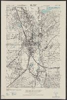
Alternative Title:
GSGS (Series) ; 4380. and Provisional GSGS; 4380
Description:
"Copied from Italy 1:50,000 map 176-I.", In upper margin: Italy 1:10,000 ..., Military grid., and Principal streets and other features are named.
Publisher:
Army Map Service, U. S. Army,
Subject (Geographic):
Barletta (Italy)--Maps
Found in:
Beinecke Rare Book and Manuscript Library > Barletta [cartographic material] : city plan / prepared under the direction of the chief of engineers, U. S. Army.
Creator:
Published / Created:
1943
Call Number:
38 B41 1943
Container / Volume:
BRBL_00156
Image Count:
1
Resource Type:
Maps, Atlases & Globes
Alternative Title:
Its A.M.S. ; M961 and Series (Standard map series designation system) ; M961.
Description:
"Copied from France 1:20,000 map XXXVI-21-1 Belfort 1906.", At head of title: France., Military grid., and Some buildings are named.
Publisher:
Army Map Service,
Subject (Geographic):
Belfort (France)--Maps
Found in:
Beinecke Rare Book and Manuscript Library > Belfort [cartographic material] : city plan / prepared under the direction of the Chief of Engineers, U.S. Army.
Creator:
Published / Created:
1947
Call Number:
739 B41 1947
Container / Volume:
BRBL_00389
Image Count:
1
Resource Type:
Maps, Atlases & Globes
Alternative Title:
[United States. Army Map Service]. A.M.S. ; A521 and Series (Standard map series designation system) ; A521.
Description:
Area covered includes ranges 2 and 3 of Coast Land District, west of Bella Coola., Insets: Index map -- Inset map[s] "A"-"C" [in margin]., and Military grid.
Publisher:
Army Map Service,
Subject (Geographic):
Bella Coola (B.C.)--Environs--Maps
Subject (Topic):
Coasts--British Columbia--Maps
Found in:
Beinecke Rare Book and Manuscript Library > Bella Coola. Preliminary map. 1924. AMS 2.
Creator:
Published / Created:
1943
Call Number:
40 B414 1943
Container / Volume:
BRBL_00204
Image Count:
1
Resource Type:
Maps, Atlases & Globes
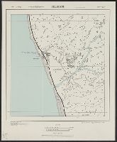
Alternative Title:
GSGS (Series) ; 4380. and Provisional GSGS; 4380
Description:
"Copied from Italy 1:50,000 map 287-I." and In upper margin: Italy 1:10,000 ...
Publisher:
Army Map Service, U. S. Army,
Subject (Geographic):
Belvedere Marittimo (Italy)--Maps
Found in:
Beinecke Rare Book and Manuscript Library > Belvedere [cartographic material] : city plan / prepared under the direction of the chief of engineers, U. S. Army.
Creator:
Published / Created:
1943
Call Number:
40 B54 1943
Container / Volume:
BRBL_00205
Image Count:
1
Resource Type:
Maps, Atlases & Globes
Alternative Title:
GSGS (Series) ; 4380. and Provisional GSGS ; 4380
Description:
"Copied from Italy 1:50,000 map 177-IV.", In upper margin: Italy 1:10,000 ..., and Military grid.
Publisher:
Army Map Service, U. S. Army,
Subject (Geographic):
Bisceglie (Italy)--Maps
Found in:
Beinecke Rare Book and Manuscript Library > Bisceglie [cartographic material] : city plan / prepared under the direction of the chief of engineers, U. S. Army.
Creator:
Published / Created:
1943
Call Number:
213 B63 1943
Container / Volume:
BRBL_00015
Image Count:
1
Resource Type:
Maps, Atlases & Globes
Alternative Title:
G.S.,G.S. ; no. 4111 and GSGS (Series) ; 4111.
Description:
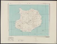
Elevations shown by form lines and spot heights., In upper margin: Cape Verde ids ..., and Military grid.
Publisher:
Army Map Service, U.S. Army,
Subject (Geographic):
Boa Vista, Cape Verde Islands--Maps, Topographic and Cabo Verde--Maps
Found in:
Beinecke Rare Book and Manuscript Library > Boa Vista / drawn at War Office, 1940, from a Portuguese map of 1924.
Creator:
Published / Created:
1943
Call Number:
38 B66 1943
Container / Volume:
BRBL_00156
Image Count:
1
Resource Type:
Maps, Atlases & Globes
Alternative Title:
Its A.M.S. ; M961 and Series (Standard map series designation system) ; M961.
Description:
"Copied from I.S.I.S. report, 1:6,632, Boulogne, CB 1804 no. 9, 1939.", At head of title: France., Military grid., and Some buildings are named.
Publisher:
Army Map Service,
Subject (Geographic):
Boulogne-sur-Mer (France)--Maps
Found in:
Beinecke Rare Book and Manuscript Library > Boulogne [cartographic material] : city plan / prepared under the direction of the Chief of Engineers, U.S. Army.
Creator:
Published / Created:
1943
Call Number:
38 B75 1943
Container / Volume:
BRBL_00156
Image Count:
1
Resource Type:
Maps, Atlases & Globes
Alternative Title:
France 1:6,670, Great Britain. War Office. General Staff. Geographical Section. [G.S.G.S.] ; 4234, and GSGS (Series) ; 4234.
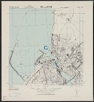
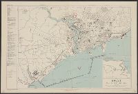
Description:
"9-43.", Important streets are named and an Index of important buildings and industries is included., Includes index., Inset: Lanvéoc Poulmic Naval Air Station., Military grid., and Relief shown by hachures.
Publisher:
Army Map Service, U.S. Army,
Subject (Geographic):
Brest (France)--Maps
Found in:
Beinecke Rare Book and Manuscript Library > Brest [cartographic material] : plan of port and town / compiled and drawn by Inter-service Topographical Dept.
Branch:v1.61.8 ,Deployed:2024-06-20T11:14:48-04:00