Skip to search
Skip to main content
Skip to first result
Search
You Searched For
Date
Unknown
Extent of Digitization
Completely digitized
Access
Public
Repository
Beinecke Rare Book and Manuscript Library
Format
cartographic
Publication Place
n.p
Date Created
[Missing]
New Search
Search Results
Creator:
Published / Created:
undated
Call Number:
WA MSS 303
Collection Title:
Lewis and Clark Expedition maps and receipt, ca. 1803-1810
Container / Volume:
Box 2 | Folder 59r
Image Count:
1
Subject (Topic):
Lewis and Clark Expedition (1804-1806) and West (U.S.)
Found in:
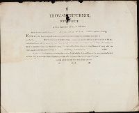
Beinecke Rare Book and Manuscript Library > Printed form used by Captains during the Expedition: "Thomas Jefferson, President of the United States of America. From the powers vested in us and [blank] by the above authority: To all who shall see these presents, Greeting: Know ye, that from the spec
Creator:
Published / Created:
undated
Call Number:
WA MSS 303
Collection Title:
Lewis and Clark Expedition maps and receipt, ca. 1803-1810
Container / Volume:
Box 2 | Folder 37
Image Count:
2
Description:
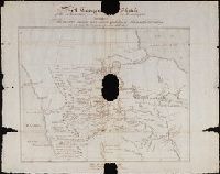
References: Moulton 73 and References: Thwaites 31-1 and 31-2
Subject (Topic):
Lewis and Clark Expedition (1804-1806) and West (U.S.)
Found in:
Beinecke Rare Book and Manuscript Library > Route about October 11-13, 1805, and return camps for May 3 and 4, 1806
Creator:
Published / Created:
undated
Call Number:
WA MSS 303
Collection Title:
Lewis and Clark Expedition maps and receipt, ca. 1803-1810
Container / Volume:
Box 1 | Folder 1
Image Count:
2
Alternative Title:
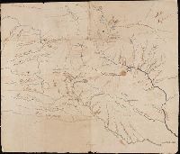
Topogr[aphical] Sketch of the Missouri and Upper Mississippi, Exhibiting The various Nations and Tribes of Indians who inhabit the Country: Copied from the original Spanish MS Map
Description:
Caption title: "A Topogr[aphical] Sketch of the Missouri and Upper Mississippi, Exhibiting The various Nations and Tribes of Indians who inhabit the Country: Copied from the original Spanish MS Map.", References:Moulton 4, and References:Thwaites 2
Subject (Topic):
Lewis and Clark Expedition (1804-1806) and West (U.S.)
Found in:
Beinecke Rare Book and Manuscript Library > Soulard's Map of 1795
Creator:
Published / Created:
undated
Call Number:
WA MSS 303
Collection Title:
Lewis and Clark Expedition maps and receipt, ca. 1803-1810
Container / Volume:
Box 1 | Folder 2
Image Count:
2
Description:
References:Thwaites 3
Subject (Topic):
Lewis and Clark Expedition (1804-1806) and West (U.S.)
Found in:
Beinecke Rare Book and Manuscript Library > The Upper Mississippi system, and the Missouri system as far as the Mandans
Branch:v1.61.8 ,Deployed:2024-06-20T11:15:04-04:00