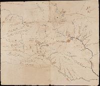
Lewis and Clark Expedition maps and receipt, ca. 1803-1810
Container / Volume:
Box 1 | Folder 1
Image Count:
2
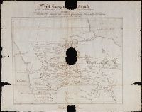
Alternative Title:
Topogr[aphical] Sketch of the Missouri and Upper Mississippi, Exhibiting The various Nations and Tribes of Indians who inhabit the Country: Copied from the original Spanish MS Map
Description:
Caption title: "A Topogr[aphical] Sketch of the Missouri and Upper Mississippi, Exhibiting The various Nations and Tribes of Indians who inhabit the Country: Copied from the original Spanish MS Map.", References:Moulton 4, and References:Thwaites 2
Subject (Topic):
Lewis and Clark Expedition (1804-1806) and West (U.S.)
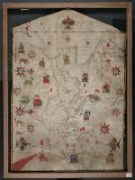
Contains eleven compass roses., Decoration: city views with banners, figures sitting on thrones, holding swords and armorial shields; animals; three fleur-de-lis., Imperfect: chipped along bottom edge, with some loss of map., Includes degrees of latitude along left edge: 25°N to 65°N., Pen-and-ink in black, red, blue and green., Portolan chart with seaport names given for all coastlines., and Title devised by cataloger.
Subject (Geographic):
Black Sea--Maps--Early works to 1800., Mediterranean Sea--Maps--Early works to 1800., and North Atlantic Ocean--Maps--Early works to 1800.
Subject (Topic):
Nautical charts--Black Sea--Early works to 1800., Nautical charts--Mediterranean Sea--Early works to 1800., and Nautical charts--North Atlantic Ocean--Early works to 1800.