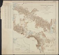
Map of the country north and south of the Anglo German boundary reduced from the surveys of the British and German sections of the Commissions during the years 1904-1906
Description:
"Note. For information concerning the construction of this map, see the paper by Captain G.E. Smith, R.E., and the note by Captain T.T. Behrens, R.E., in the 'Geographical Journal' for March and July 1907.", "Section II.", and In upper right margin: Victoria Ny
Publisher:
Royal Geographical Society,
Subject (Geographic):
Kenya--Boundaries--Tanzania--Maps and Tanzania--Boundaries--Kenya--Maps