
You Searched For
1 - 4 of 4
Search Results
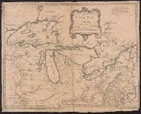
2.
- Creator:
- Bellin, Jacques Nicolas, 1703-1772, cartographer
- Published / Created:
- 1755
- Call Number:
- 8075 1755
- Container / Volume:
- BRBL_00731
- Image Count:
- 1
- Resource Type:
- Maps, Atlases & Globes
- Abstract:
- Shows Great Lakes region.
- Description:
- Covers the area from Lake Superior to Kaskaskia and from Delaware Bay to the Mississippi River., Relief shown pictorially., Shows a few towns, missions, forts, Indian villages and tribal territory, rivers and lakes, portages, and early place-names., and Watermark.
- Publisher:
- [Homann Erben?],
- Subject (Geographic):
- Canada--Maps--Early works to 1800, Great Lakes Region (North America)--Maps--Early works to 1800, and New France--Maps--Early works to 1800
- Subject (Name):
- Brown, Horace--Stamp, Homann Erben (Firm), and Thorne Collection of Cartogaphy and Geography Stamp
- Found in:
- Beinecke Rare Book and Manuscript Library > Partie occidentale de la Nouvelle France ou du Canada / par Mr. Bellin, ingenieur du Roy et de la Marine, pour seruir à l'intelligence des affaires et de l'etat present en Amerique, communiquée au public par les Heritiers de Homanen l'an 1755.
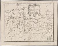
3.
- Creator:
- Bellin, Jacques Nicolas, 1703-1772, cartographer
- Published / Created:
- 1755
- Call Number:
- 755 1755M
- Container / Volume:
- BRBL_00427
- Image Count:
- 1
- Resource Type:
- Maps, Atlases & Globes
- Abstract:
- Shows Great Lakes region.
- Description:
- Copy 1: Borders of lakes and frame of map colored in yellow. Backed with linen. Stamp: Thorne Collection of Cartography and Geography. Stamp: Karpinski-von Wieser Map Collection., Covers the area from Lake Superior to Kaskaskia and from Delaware Bay to the Mississippi River., Relief shown pictorially., Shows a few towns, missions, forts, Indian villages and tribal territory, rivers and lakes, portages, and early place-names., and Watermark.
- Publisher:
- [Homann Erben?],
- Subject (Geographic):
- Canada--Maps--Early works to 1800, Great Lakes Region (North America)--Maps--Early works to 1800, and New France--Maps--Early works to 1800
- Subject (Name):
- Homann Erben (Firm) and Thorne Collection of Cartogaphy and Geography Stamp
- Found in:
- Beinecke Rare Book and Manuscript Library > Partie occidentale de la Nouvelle France ou du Canada / par Mr. Bellin, ingenieur du Roy et de la Marine, pour seruir à l'intelligence des affaires et de l'etat present en Amerique, communiquée au public par les Heritiers de Homanen l'an 1755.
4.
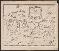
- Creator:
- Bellin, Jacques Nicolas, 1703-1772, cartographer
- Published / Created:
- 1755
- Call Number:
- 755 1755M
- Container / Volume:
- BRBL_00427
- Image Count:
- 1
- Resource Type:
- Maps, Atlases & Globes
- Abstract:
- Shows Great Lakes region.
- Description:
- Copy 2: Stamp: Yale Horace Brown 1900S. Manuscript note in unidentified hand., Covers the area from Lake Superior to Kaskaskia and from Delaware Bay to the Mississippi River., Relief shown pictorially., and Shows a few towns, missions, forts, Indian villages and tribal territory, rivers and lakes, portages, and early place-names.
- Publisher:
- [Homann Erben?],
- Subject (Geographic):
- Canada--Maps--Early works to 1800, Great Lakes Region (North America)--Maps--Early works to 1800, and New France--Maps--Early works to 1800
- Subject (Name):
- Brown, Horace--Stamp and Homann Erben (Firm)
- Found in:
- Beinecke Rare Book and Manuscript Library > Partie occidentale de la Nouvelle France ou du Canada / par Mr. Bellin, ingenieur du Roy et de la Marine, pour seruir à l'intelligence des affaires et de l'etat present en Amerique, communiquée au public par les Heritiers de Homanen l'an 1755.