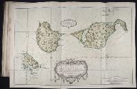
BEIN 2003 Folio 85: No. 11 of 45 maps bound together with binder's spine title: Atlas of America; ms. table of contents. Bookplate: Robinson. Bookplate of Paul Mellon., Hand colored., Leve sure les lieux a 6 lignes pour cent toises par le Sr Fortin, ingenieur geographe., par le Sr. Bellin, ingenieur de la Marine., Relief shown pictorially. Depths shown by soundings., and Scale [ca. 1:50,000].
Publisher:
s.n
Subject (Topic):
Coasts -- Saint Pierre and Miquelon -- Maps -- Early works to 1800 and Nautical charts -- Saint Pierre and Miquelon -- Early works to 1800