Bellin, Jacques Nicolas, 1703-1772, creator France, Depot des cartes et plans de la marine
Published / Created:
1755?
Call Number:
2003 Folio 85
Image Count:
1
Description:
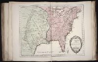
Available also through the Library of Congress Web site as a raster image., BEIN 2003 Folio 85: No. 23 of 45 maps bound together with binder's spine title: Atlas of America; ms. table of contents. Bookplate: Robinson. Bookplate of Paul Mellon., Covers the area from Quebec to the Gulf of Mexico and west of Santa Fe, N.M., Hand colored., LC Maps of North America, 1750-1789,, Longitude du meridien de l'ile de Fer., Par le Sr. Bellin, ingr. ordre. de la marine, 1750., Relief shown pictorially., Scale [ca. 1:5,800,000]., Shows cities and towns, forts, some trails, and Indian villages and tribal territory., and Sur de nouvelles observations on a corrige les lacs, et leurs environs, 1755.
Subject (Geographic):
Louisiana -- Maps -- Early works to 1800 and North America -- Maps -- Early works to 1800